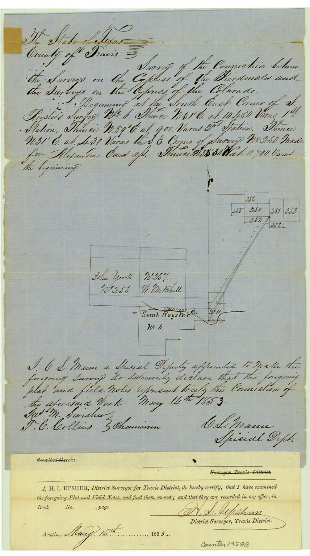
Blanco County Sketch File 10
[Survey of the connection between surveys on the Cypress Creek of the Pedernales River and surveys on the Cypress Creek of the Colorado River]
-
Map/Doc
14588
-
Collection
General Map Collection
-
Object Dates
1853/5/14 (Creation Date)
-
People and Organizations
C.S. Mann (Surveyor/Engineer)
Jas. M. Swisher (Chainman/Field Personnel)
T.C. Collins (Chainman/Field Personnel)
-
Counties
Blanco Burnet
-
Subjects
Surveying Sketch File
-
Height x Width
14.6 x 8.2 inches
37.1 x 20.8 cm
-
Medium
paper, manuscript
-
Features
Cypress Creek Branch of the Pedernales River
Cypress Creek Branch of the Colorado River
Cypress Creek
Part of: General Map Collection
Schleicher County Sketch File 42

Print $40.00
- Digital $50.00
Schleicher County Sketch File 42
1963
Size 16.3 x 14.4 inches
Map/Doc 36546
Lamar County Sketch File 16

Print $166.00
- Digital $50.00
Lamar County Sketch File 16
2013
Size 11.0 x 8.5 inches
Map/Doc 93654
Outer Continental Shelf Leasing Maps (Louisiana Offshore Operations)

Print $20.00
- Digital $50.00
Outer Continental Shelf Leasing Maps (Louisiana Offshore Operations)
1959
Size 17.8 x 14.0 inches
Map/Doc 76106
Right of Way and Track Map of The Missouri, Kansas & Texas Railway of Texas

Print $40.00
- Digital $50.00
Right of Way and Track Map of The Missouri, Kansas & Texas Railway of Texas
1918
Size 25.9 x 108.3 inches
Map/Doc 64526
Map of Taylor, Bastrop & Houston Railroad in Austin County

Print $20.00
- Digital $50.00
Map of Taylor, Bastrop & Houston Railroad in Austin County
Size 14.6 x 25.1 inches
Map/Doc 64480
San Patricio County Sketch File 38

Print $112.00
- Digital $50.00
San Patricio County Sketch File 38
Size 7.9 x 7.3 inches
Map/Doc 36176
Montague County Rolled Sketch R

Print $20.00
- Digital $50.00
Montague County Rolled Sketch R
Size 44.3 x 29.8 inches
Map/Doc 6794
Flight Mission No. CRC-3R, Frame 23, Chambers County

Print $20.00
- Digital $50.00
Flight Mission No. CRC-3R, Frame 23, Chambers County
1956
Size 18.6 x 22.3 inches
Map/Doc 84797
Brewster County Working Sketch 28

Print $20.00
- Digital $50.00
Brewster County Working Sketch 28
1940
Size 23.5 x 32.9 inches
Map/Doc 67562
Menard County Boundary File 11

Print $2.00
- Digital $50.00
Menard County Boundary File 11
Size 11.2 x 8.7 inches
Map/Doc 57098
Limestone County Working Sketch 6

Print $20.00
- Digital $50.00
Limestone County Working Sketch 6
1922
Size 31.5 x 33.3 inches
Map/Doc 70556
Liberty County Working Sketch 14

Print $20.00
- Digital $50.00
Liberty County Working Sketch 14
1919
Size 17.0 x 25.4 inches
Map/Doc 70473
You may also like

Chambers County Sketch File 11

Print $40.00
- Digital $50.00
Chambers County Sketch File 11
Size 13.7 x 12.6 inches
Map/Doc 17554
Chambers County Sketch File 13

Print $6.00
- Digital $50.00
Chambers County Sketch File 13
1873
Size 9.8 x 12.4 inches
Map/Doc 17558
Runnels County Sketch File 5

Print $22.00
Runnels County Sketch File 5
Size 12.8 x 16.0 inches
Map/Doc 35436
Flight Mission No. DCL-7C, Frame 61, Kenedy County

Print $20.00
- Digital $50.00
Flight Mission No. DCL-7C, Frame 61, Kenedy County
1943
Size 15.4 x 15.2 inches
Map/Doc 86049
McCulloch County, Texas

Print $20.00
- Digital $50.00
McCulloch County, Texas
1879
Size 24.6 x 18.0 inches
Map/Doc 573
Hood County Working Sketch 1

Print $20.00
- Digital $50.00
Hood County Working Sketch 1
1934
Size 18.2 x 24.5 inches
Map/Doc 66195
Roberts County Working Sketch 6

Print $20.00
- Digital $50.00
Roberts County Working Sketch 6
1952
Size 29.3 x 21.9 inches
Map/Doc 63532
Trinity County Working Sketch 5

Print $20.00
- Digital $50.00
Trinity County Working Sketch 5
1914
Size 18.3 x 23.9 inches
Map/Doc 69453
Dimmit County Sketch File 41

Print $4.00
- Digital $50.00
Dimmit County Sketch File 41
1901
Size 14.6 x 9.1 inches
Map/Doc 21169
Val Verde County Sketch File 40

Print $20.00
- Digital $50.00
Val Verde County Sketch File 40
1939
Size 15.3 x 25.5 inches
Map/Doc 12582
Plat Town of Swearingen, Cottle Co., Texas

Print $20.00
- Digital $50.00
Plat Town of Swearingen, Cottle Co., Texas
1918
Size 40.6 x 30.6 inches
Map/Doc 4466