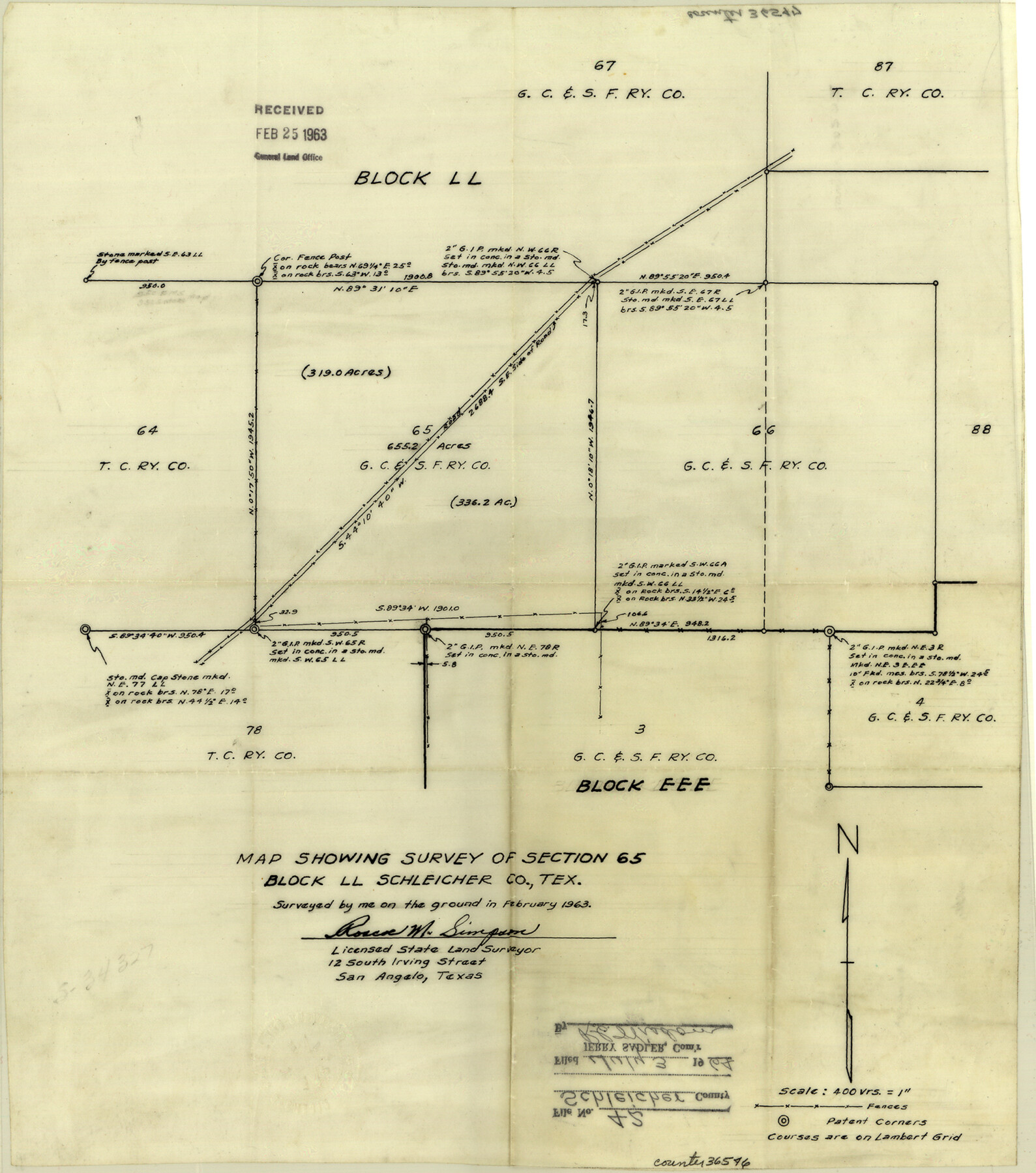
Schleicher County Sketch File 42
Map showing survey of section 65, Block LL
-
Map/Doc
36546
-
Collection
General Map Collection
-
Object Dates
2/1963 (Creation Date)
-
People and Organizations
Roscoe M. Simpson (Surveyor/Engineer)
-
Counties
Schleicher
-
Subjects
Surveying Sketch File
-
Height x Width
16.3 x 14.4 inches
41.4 x 36.6 cm
-
Medium
paper, manuscript
-
Scale
1" = 400 varas
Part of: General Map Collection
Flight Mission No. DQN-3K, Frame 12, Calhoun County

Print $20.00
- Digital $50.00
Flight Mission No. DQN-3K, Frame 12, Calhoun County
1953
Size 18.8 x 22.4 inches
Map/Doc 84344
Flight Mission No. DAG-24K, Frame 152, Matagorda County

Print $20.00
- Digital $50.00
Flight Mission No. DAG-24K, Frame 152, Matagorda County
1953
Size 18.4 x 22.3 inches
Map/Doc 86566
Dickens County Sketch File F

Print $4.00
- Digital $50.00
Dickens County Sketch File F
1901
Size 6.9 x 10.7 inches
Map/Doc 20847
Reeves County Rolled Sketch 1

Print $40.00
- Digital $50.00
Reeves County Rolled Sketch 1
Size 52.9 x 38.5 inches
Map/Doc 9844
Shelby County Working Sketch 27

Print $20.00
- Digital $50.00
Shelby County Working Sketch 27
1995
Size 32.8 x 39.9 inches
Map/Doc 63881
Childress Co.

Print $20.00
- Digital $50.00
Childress Co.
1892
Size 40.3 x 33.7 inches
Map/Doc 66752
Map of the Reconnaissance in Texas by Lieuts Blake & Meade of the Corps of Topl. Engrs.

Print $20.00
- Digital $50.00
Map of the Reconnaissance in Texas by Lieuts Blake & Meade of the Corps of Topl. Engrs.
1845
Size 27.7 x 18.5 inches
Map/Doc 72892
Brazoria County Working Sketch 15

Print $20.00
- Digital $50.00
Brazoria County Working Sketch 15
1940
Size 18.2 x 38.6 inches
Map/Doc 67500
Right-of-Way Map Seawall Extension Galveston Island

Print $40.00
- Digital $50.00
Right-of-Way Map Seawall Extension Galveston Island
1958
Size 16.4 x 62.8 inches
Map/Doc 73617
Flight Mission No. BRA-7M, Frame 190, Jefferson County

Print $20.00
- Digital $50.00
Flight Mission No. BRA-7M, Frame 190, Jefferson County
1953
Size 18.7 x 22.3 inches
Map/Doc 85558
Runnels County Rolled Sketch 42

Print $20.00
- Digital $50.00
Runnels County Rolled Sketch 42
1951
Size 30.8 x 37.4 inches
Map/Doc 7530
Right of Way and Track Map, Galveston, Harrisburg & San Antonio Ry. operated by the T. & N. O. R.R. Co., Victoria Division, Rosenberg to Beeville

Print $40.00
- Digital $50.00
Right of Way and Track Map, Galveston, Harrisburg & San Antonio Ry. operated by the T. & N. O. R.R. Co., Victoria Division, Rosenberg to Beeville
1918
Size 25.1 x 57.9 inches
Map/Doc 76157
You may also like
Nueces County Rolled Sketch 52

Print $20.00
- Digital $50.00
Nueces County Rolled Sketch 52
1938
Size 31.3 x 31.7 inches
Map/Doc 9606
Roberts County Working Sketch 24

Print $20.00
- Digital $50.00
Roberts County Working Sketch 24
1981
Size 25.8 x 36.9 inches
Map/Doc 63550
Erath County Sketch File 9

Print $4.00
- Digital $50.00
Erath County Sketch File 9
1870
Size 8.2 x 8.4 inches
Map/Doc 22273
Bird's Eye View of El Paso

Print $20.00
Bird's Eye View of El Paso
1885
Size 20.0 x 30.0 inches
Map/Doc 93621
Eastland County Working Sketch 53

Print $20.00
- Digital $50.00
Eastland County Working Sketch 53
1982
Size 22.9 x 27.4 inches
Map/Doc 68834
Aransas Pass to Baffin Bay

Print $20.00
- Digital $50.00
Aransas Pass to Baffin Bay
1946
Size 42.1 x 34.3 inches
Map/Doc 73412
Freestone County Working Sketch 22

Print $20.00
- Digital $50.00
Freestone County Working Sketch 22
1981
Size 35.5 x 32.3 inches
Map/Doc 69264
Nueces County Rolled Sketch 65

Print $20.00
- Digital $50.00
Nueces County Rolled Sketch 65
1979
Size 19.5 x 26.2 inches
Map/Doc 6917
Kendall County Working Sketch 2

Print $20.00
- Digital $50.00
Kendall County Working Sketch 2
1941
Size 28.6 x 21.1 inches
Map/Doc 66674
Flight Mission No. BRA-17M, Frame 7, Jefferson County

Print $20.00
- Digital $50.00
Flight Mission No. BRA-17M, Frame 7, Jefferson County
1953
Size 18.7 x 22.3 inches
Map/Doc 85788
A Map of the United States including every county enumerated in the last census & since formed with the population of the several states, railroads, canals, & c.

A Map of the United States including every county enumerated in the last census & since formed with the population of the several states, railroads, canals, & c.
Size 46.0 x 61.0 inches
Map/Doc 95918
Terrell County Rolled Sketch 9

Print $20.00
- Digital $50.00
Terrell County Rolled Sketch 9
Size 17.6 x 42.9 inches
Map/Doc 7925