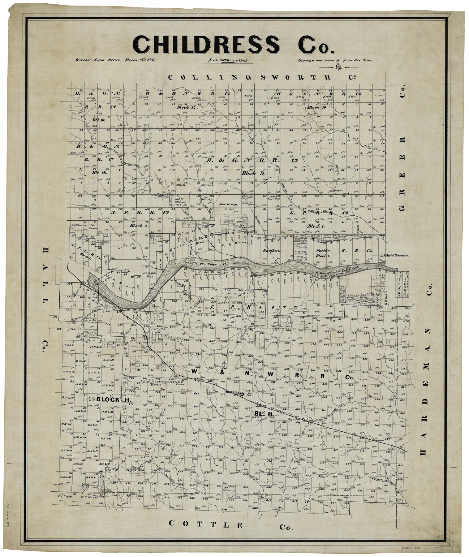
Childress Co.
-
Map/Doc
66752
-
Collection
General Map Collection
-
Object Dates
3/15/1892 (Creation Date)
-
People and Organizations
Texas General Land Office (Publisher)
John MacBean (Compiler)
John MacBean (Draftsman)
-
Counties
Childress
-
Subjects
County
-
Height x Width
40.3 x 33.7 inches
102.4 x 85.6 cm
Part of: General Map Collection
Foard County Rolled Sketch 15A

Print $20.00
- Digital $50.00
Foard County Rolled Sketch 15A
1889
Size 37.3 x 39.8 inches
Map/Doc 75936
Tom Green County Sketch File 88

Print $8.00
- Digital $50.00
Tom Green County Sketch File 88
1990
Size 11.5 x 8.9 inches
Map/Doc 38266
Cameron County Sketch File 16

Print $18.00
- Digital $50.00
Cameron County Sketch File 16
1998
Size 11.2 x 8.6 inches
Map/Doc 76334
Kerr County Boundary File 5

Print $8.00
- Digital $50.00
Kerr County Boundary File 5
Size 14.2 x 8.7 inches
Map/Doc 64818
Archer County

Print $20.00
- Digital $50.00
Archer County
1926
Size 42.9 x 37.8 inches
Map/Doc 73070
Reagan County Working Sketch 14a

Print $20.00
- Digital $50.00
Reagan County Working Sketch 14a
1949
Size 25.9 x 15.2 inches
Map/Doc 71854
Flight Mission No. BQR-4K, Frame 71, Brazoria County

Print $20.00
- Digital $50.00
Flight Mission No. BQR-4K, Frame 71, Brazoria County
1952
Size 18.8 x 22.4 inches
Map/Doc 84004
Flight Mission No. CRK-8P, Frame 106, Refugio County

Print $20.00
- Digital $50.00
Flight Mission No. CRK-8P, Frame 106, Refugio County
1956
Size 18.3 x 22.1 inches
Map/Doc 86967
Richardson's New Map of the State of Texas prepared for the Texas Almanac

Print $20.00
- Digital $50.00
Richardson's New Map of the State of Texas prepared for the Texas Almanac
1873
Size 19.8 x 27.1 inches
Map/Doc 96873
Flight Mission No. CRC-3R, Frame 102, Chambers County

Print $20.00
- Digital $50.00
Flight Mission No. CRC-3R, Frame 102, Chambers County
1956
Size 18.7 x 22.5 inches
Map/Doc 84840
Hidalgo County Sketch File 1

Print $40.00
- Digital $50.00
Hidalgo County Sketch File 1
Size 20.2 x 12.0 inches
Map/Doc 26392
Matagorda County Sketch File 25

Print $20.00
- Digital $50.00
Matagorda County Sketch File 25
1903
Size 18.1 x 30.3 inches
Map/Doc 12041
You may also like
Starr County Rolled Sketch 42

Print $20.00
- Digital $50.00
Starr County Rolled Sketch 42
1972
Size 26.0 x 18.4 inches
Map/Doc 7835
Stieler Map of 1879

Print $4.00
- Digital $50.00
Stieler Map of 1879
1879
Size 28.9 x 23.0 inches
Map/Doc 76057
The Republic County of San Patricio. Proposed, Late Fall 1837

Print $20.00
The Republic County of San Patricio. Proposed, Late Fall 1837
2020
Size 17.8 x 21.7 inches
Map/Doc 96273
El Paso County Working Sketch 34

Print $40.00
- Digital $50.00
El Paso County Working Sketch 34
1974
Size 53.4 x 34.7 inches
Map/Doc 69056
Edwards County Working Sketch 125

Print $20.00
- Digital $50.00
Edwards County Working Sketch 125
1977
Size 22.3 x 23.5 inches
Map/Doc 69001
Map of Henderson Co.

Print $40.00
- Digital $50.00
Map of Henderson Co.
1886
Size 27.8 x 57.6 inches
Map/Doc 3663
[Sketch of all of County]
![89972, [Sketch of all of County], Twichell Survey Records](https://historictexasmaps.com/wmedia_w700/maps/89972-1.tif.jpg)
Print $40.00
- Digital $50.00
[Sketch of all of County]
Size 71.0 x 44.3 inches
Map/Doc 89972
Montgomery County Rolled Sketch 50

Print $20.00
- Digital $50.00
Montgomery County Rolled Sketch 50
2016
Size 24.1 x 35.7 inches
Map/Doc 95685
Clay County Boundary File 14

Print $80.00
- Digital $50.00
Clay County Boundary File 14
Size 63.1 x 15.4 inches
Map/Doc 51416
Brazoria County Rolled Sketch 23

Print $20.00
- Digital $50.00
Brazoria County Rolled Sketch 23
1931
Size 39.2 x 37.3 inches
Map/Doc 10691
[Map Showing Parmer, Castro, Bailey, Lamb, Cochran & Hockley Counties, Texas]
![1762, [Map Showing Parmer, Castro, Bailey, Lamb, Cochran & Hockley Counties, Texas], General Map Collection](https://historictexasmaps.com/wmedia_w700/maps/1762.tif.jpg)
Print $40.00
- Digital $50.00
[Map Showing Parmer, Castro, Bailey, Lamb, Cochran & Hockley Counties, Texas]
1910
Size 55.3 x 40.1 inches
Map/Doc 1762
[Sketch for Mineral Application 12206 - Cow Bayou, O. B. Sawyer]
![65568, [Sketch for Mineral Application 12206 - Cow Bayou, O. B. Sawyer], General Map Collection](https://historictexasmaps.com/wmedia_w700/maps/65568.tif.jpg)
Print $40.00
- Digital $50.00
[Sketch for Mineral Application 12206 - Cow Bayou, O. B. Sawyer]
Size 37.4 x 140.2 inches
Map/Doc 65568