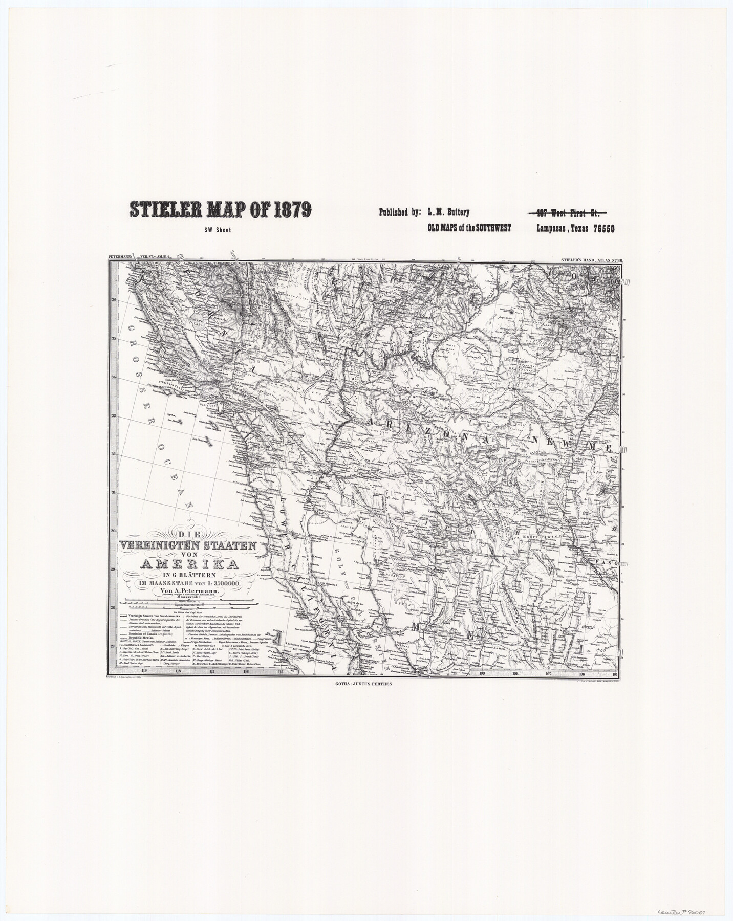
Stieler Map of 1879
-
Map/Doc
76057
-
Collection
General Map Collection
-
Object Dates
1879 (Creation Date)
-
Subjects
Old Southwest State of Texas
-
Height x Width
28.9 x 23.0 inches
73.4 x 58.4 cm
Part of: General Map Collection

Val Verde County Rolled Sketch 71

Print $20.00
- Digital $50.00
Val Verde County Rolled Sketch 71
1958
Size 19.5 x 19.5 inches
Map/Doc 8133
Travis County Working Sketch 59

Print $20.00
- Digital $50.00
Travis County Working Sketch 59
1992
Size 33.1 x 29.0 inches
Map/Doc 69443

Hunt County Sketch File 35

Print $4.00
- Digital $50.00
Hunt County Sketch File 35
Size 5.3 x 8.3 inches
Map/Doc 27148
Erath County Sketch File 32

Print $8.00
- Digital $50.00
Erath County Sketch File 32
1936
Size 11.5 x 8.8 inches
Map/Doc 22311
Coryell County Working Sketch 9

Print $20.00
- Digital $50.00
Coryell County Working Sketch 9
1947
Size 28.7 x 30.0 inches
Map/Doc 68216
Brooks County Sketch File 9

Print $2.00
- Digital $50.00
Brooks County Sketch File 9
1988
Size 14.4 x 8.8 inches
Map/Doc 16571
Jefferson County Sketch File 55

Print $30.00
- Digital $50.00
Jefferson County Sketch File 55
1982
Size 11.1 x 8.5 inches
Map/Doc 28386
Fort Bend County Working Sketch 6

Print $20.00
- Digital $50.00
Fort Bend County Working Sketch 6
1917
Size 15.7 x 15.5 inches
Map/Doc 69212
Marion County Rolled Sketch 1A

Print $15.00
- Digital $50.00
Marion County Rolled Sketch 1A
1954
Size 9.9 x 15.2 inches
Map/Doc 46610
Harrison County Rolled Sketch 2

Print $20.00
- Digital $50.00
Harrison County Rolled Sketch 2
1904
Size 29.9 x 28.0 inches
Map/Doc 6149
You may also like
Right of Way & Track Map, San Antonio & Aransas Pass Railway Co.

Print $40.00
- Digital $50.00
Right of Way & Track Map, San Antonio & Aransas Pass Railway Co.
1919
Size 25.0 x 56.7 inches
Map/Doc 64215
Maverick County Sketch File 22

Print $32.00
- Digital $50.00
Maverick County Sketch File 22
1892
Size 5.5 x 6.3 inches
Map/Doc 31136
Flight Mission No. CGI-2N, Frame 183, Cameron County

Print $20.00
- Digital $50.00
Flight Mission No. CGI-2N, Frame 183, Cameron County
1954
Size 18.7 x 22.2 inches
Map/Doc 84543
Harrison County Working Sketch 5

Print $20.00
- Digital $50.00
Harrison County Working Sketch 5
1953
Size 39.7 x 39.8 inches
Map/Doc 66025
Reagan County Sketch File 15

Print $4.00
- Digital $50.00
Reagan County Sketch File 15
1931
Size 8.0 x 13.3 inches
Map/Doc 35000
West Part of Jeff Davis Co.

Print $20.00
- Digital $50.00
West Part of Jeff Davis Co.
1977
Size 36.5 x 47.5 inches
Map/Doc 95545
Stephens County Working Sketch 18

Print $40.00
- Digital $50.00
Stephens County Working Sketch 18
1975
Size 57.4 x 32.9 inches
Map/Doc 63961
King County Rolled Sketch 9

Print $20.00
- Digital $50.00
King County Rolled Sketch 9
Size 25.9 x 34.2 inches
Map/Doc 9350
Wilbarger County Sketch File 6

Print $6.00
- Digital $50.00
Wilbarger County Sketch File 6
1874
Size 12.6 x 7.8 inches
Map/Doc 40172
Morris County Working Sketch Graphic Index

Print $20.00
- Digital $50.00
Morris County Working Sketch Graphic Index
1948
Size 42.8 x 20.1 inches
Map/Doc 76649
Map of Galveston West Bay, Galveston Island & Chocolate Bay

Print $40.00
- Digital $50.00
Map of Galveston West Bay, Galveston Island & Chocolate Bay
1852
Size 50.5 x 29.9 inches
Map/Doc 69924
[Central Part of San Miguel County]
![92038, [Central Part of San Miguel County], Twichell Survey Records](https://historictexasmaps.com/wmedia_w700/maps/92038-1.tif.jpg)
Print $20.00
- Digital $50.00
[Central Part of San Miguel County]
Size 19.5 x 16.8 inches
Map/Doc 92038