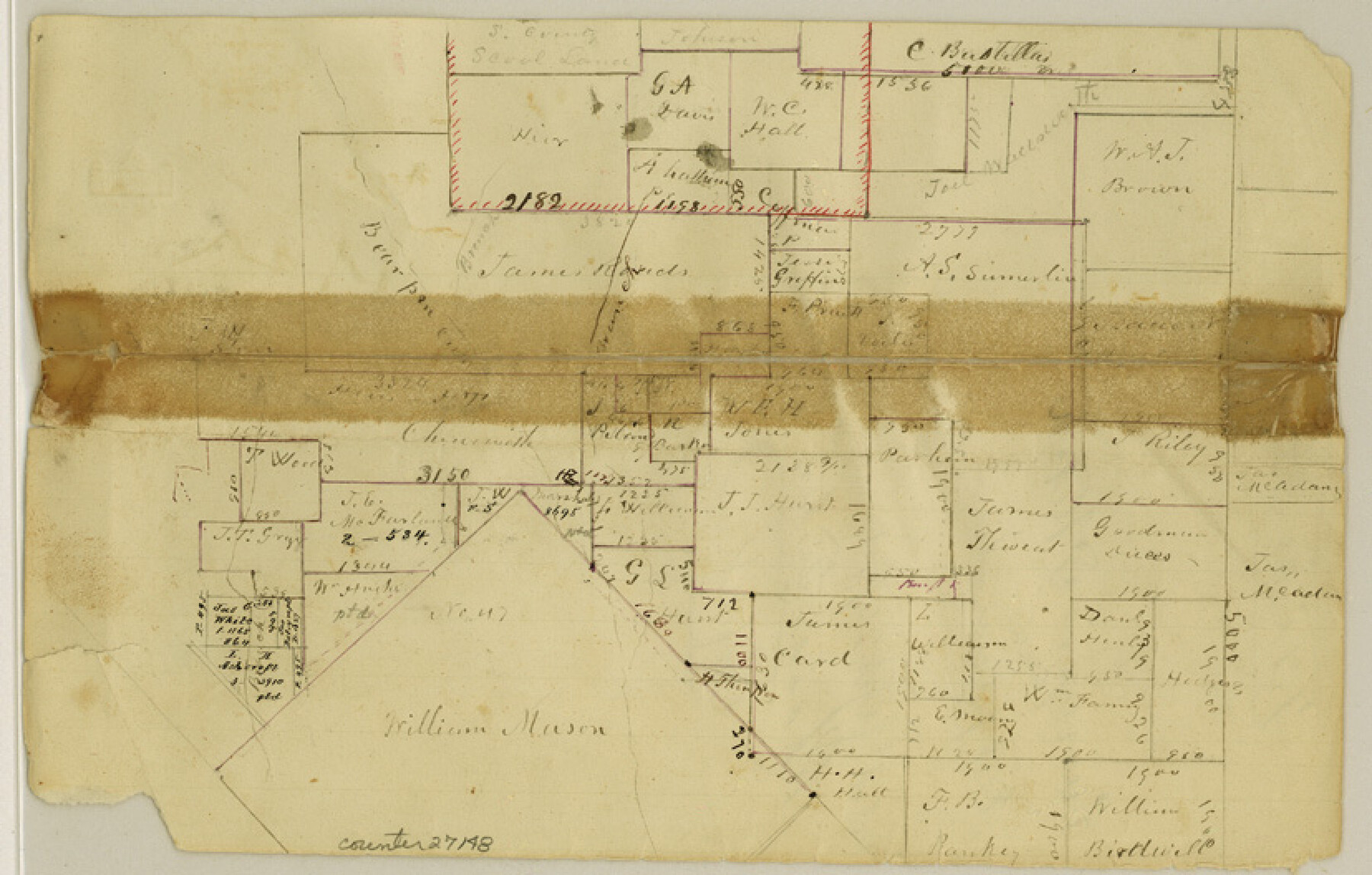
Hunt County Sketch File 35
[Sketch in southwest part of county]
-
Map/Doc
27148
-
Collection
General Map Collection
-
Object Dates
9/22/1874 (File Date)
-
Counties
Hunt Rockwall
-
Subjects
Surveying Sketch File
-
Height x Width
5.3 x 8.3 inches
13.5 x 21.1 cm
-
Medium
paper, manuscript
Part of: General Map Collection

San Saba County Working Sketch 6

Print $20.00
- Digital $50.00
San Saba County Working Sketch 6
1959
Size 17.5 x 23.4 inches
Map/Doc 63794

Flight Mission No. DCL-6C, Frame 176, Kenedy County

Print $20.00
- Digital $50.00
Flight Mission No. DCL-6C, Frame 176, Kenedy County
1943
Size 18.6 x 22.2 inches
Map/Doc 85988
Brewster County Working Sketch 13

Print $20.00
- Digital $50.00
Brewster County Working Sketch 13
1928
Size 39.5 x 43.9 inches
Map/Doc 67546
Dallas County Working Sketch 9

Print $20.00
- Digital $50.00
Dallas County Working Sketch 9
1960
Size 23.1 x 20.0 inches
Map/Doc 68575
Pecos County Working Sketch 114

Print $40.00
- Digital $50.00
Pecos County Working Sketch 114
1972
Size 75.7 x 38.0 inches
Map/Doc 71587
Hudspeth County Working Sketch 29

Print $40.00
- Digital $50.00
Hudspeth County Working Sketch 29
1972
Size 31.5 x 55.2 inches
Map/Doc 66311
Flight Mission No. BRA-6M, Frame 92, Jefferson County

Print $20.00
- Digital $50.00
Flight Mission No. BRA-6M, Frame 92, Jefferson County
1953
Size 18.5 x 22.3 inches
Map/Doc 85435
Randall County Rolled Sketch 7

Print $20.00
- Digital $50.00
Randall County Rolled Sketch 7
1949
Size 18.9 x 22.1 inches
Map/Doc 7427
Donley County

Print $20.00
- Digital $50.00
Donley County
1944
Size 46.8 x 40.6 inches
Map/Doc 95484
McMullen County Rolled Sketch 16

Print $20.00
- Digital $50.00
McMullen County Rolled Sketch 16
1949
Size 30.2 x 25.0 inches
Map/Doc 6733
You may also like
Haskell County Rolled Sketch 11

Print $20.00
- Digital $50.00
Haskell County Rolled Sketch 11
1983
Size 23.0 x 28.0 inches
Map/Doc 6170
General Highway Map, Franklin County, Morris County, Titus County, Camp County

Print $20.00
General Highway Map, Franklin County, Morris County, Titus County, Camp County
1940
Size 18.4 x 25.1 inches
Map/Doc 79040
1960 Texas Official Highway Travel Map

Digital $50.00
1960 Texas Official Highway Travel Map
Size 28.4 x 36.2 inches
Map/Doc 94329
Flight Mission No. DQO-3K, Frame 27, Galveston County

Print $20.00
- Digital $50.00
Flight Mission No. DQO-3K, Frame 27, Galveston County
1952
Size 18.7 x 22.5 inches
Map/Doc 85068
Galveston County NRC Article 33.136 Sketch 79

Print $292.00
- Digital $50.00
Galveston County NRC Article 33.136 Sketch 79
2015
Size 22.0 x 34.0 inches
Map/Doc 94880
Flight Mission No. DAG-17K, Frame 136, Matagorda County

Print $20.00
- Digital $50.00
Flight Mission No. DAG-17K, Frame 136, Matagorda County
1952
Size 18.5 x 22.3 inches
Map/Doc 86353
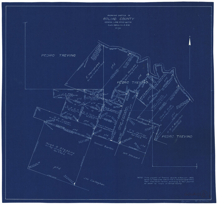
Goliad County Working Sketch 6
Print $20.00
- Digital $50.00
Goliad County Working Sketch 6
1930
Size 20.9 x 22.2 inches
Map/Doc 63196
Comanche County Sketch File 18

Print $4.00
- Digital $50.00
Comanche County Sketch File 18
Size 8.4 x 7.8 inches
Map/Doc 19091
Milam County Boundary File 1

Print $8.00
- Digital $50.00
Milam County Boundary File 1
Size 12.7 x 8.2 inches
Map/Doc 57198
Starr County Rolled Sketch 28

Print $20.00
- Digital $50.00
Starr County Rolled Sketch 28
1941
Size 29.0 x 20.6 inches
Map/Doc 7811
Travis County Rolled Sketch 39

Print $148.00
- Digital $50.00
Travis County Rolled Sketch 39
Size 6.7 x 9.9 inches
Map/Doc 49130
Duval County Rolled Sketch 43

Print $20.00
- Digital $50.00
Duval County Rolled Sketch 43
1981
Size 44.3 x 34.7 inches
Map/Doc 8820