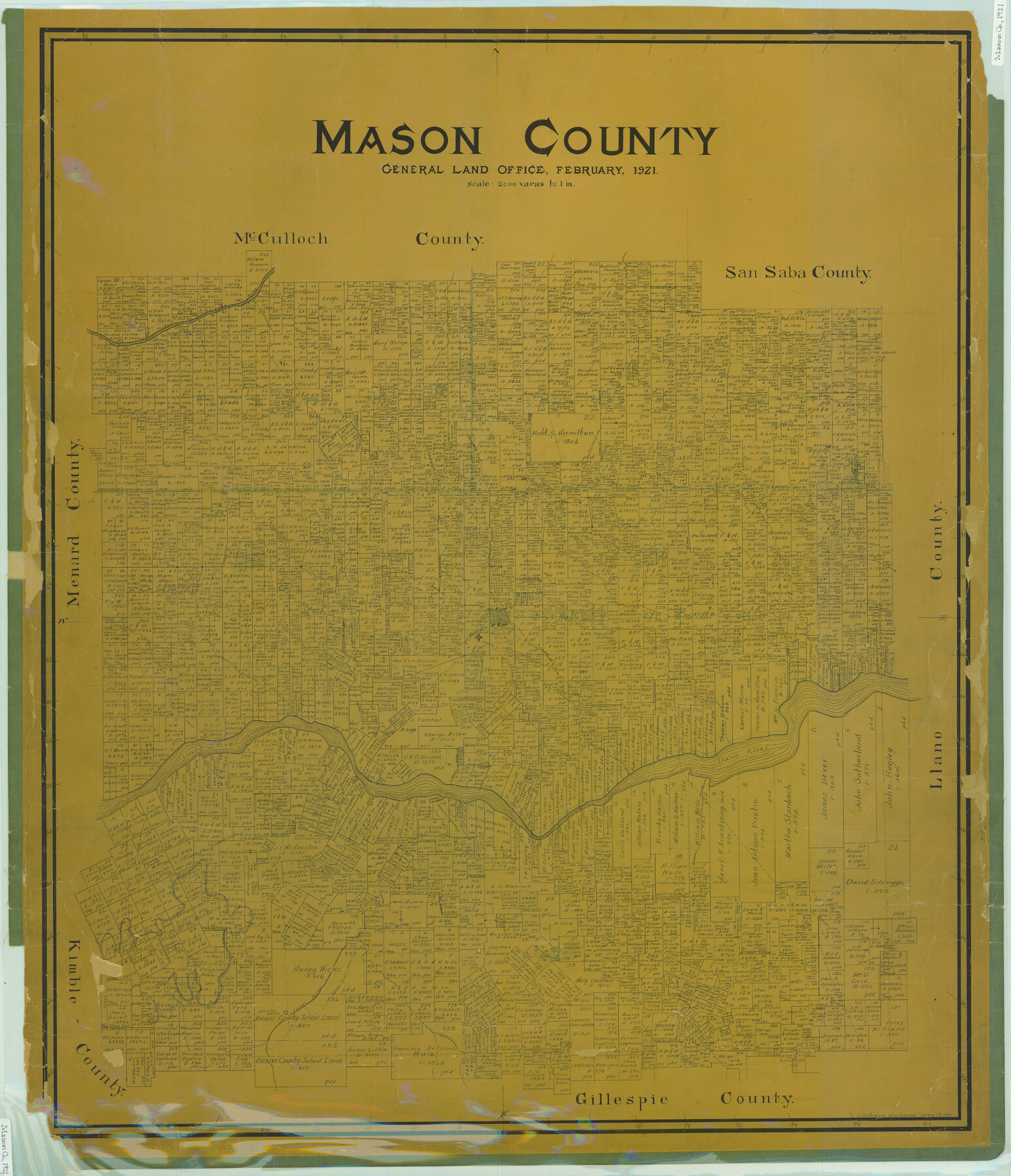
Mason County
-
Map/Doc
7953
-
Collection
General Map Collection
-
Object Dates
1921/2/16 (Creation Date)
-
People and Organizations
Texas General Land Office (Publisher)
John D. Hedick (Draftsman)
John D. Hedick (Compiler)
-
Counties
Mason
-
Subjects
County
-
Height x Width
45.0 x 38.6 inches
114.3 x 98.0 cm
-
Comments
Help Save Texas History - Adopt Me!
-
Features
West Fork of Bluff Creek
Schreiner Ranch
Salt Branch [of James River]
Loyal Valley
James River Road
James River
Fredericksburg Road
Blue Mountains
Smith Branch Road
Beaver Creek
Honey Creek
Llano River
Bluff Creek
San Saba River
Fort Mason
Comanche Creek
Mason
Menard Road
Leon Creek
Willow Creek
San Saba Road
Katemcy Road
Brady Road
South Branch of Trout Creek
Trout Creek
Part of: General Map Collection
Orange County Sketch File 10

Print $4.00
- Digital $50.00
Orange County Sketch File 10
1876
Size 8.4 x 12.8 inches
Map/Doc 33317
[Surveys in Austin's Colony along the east bank of the Navidad River]
![78488, [Surveys in Austin's Colony along the east bank of the Navidad River], General Map Collection](https://historictexasmaps.com/wmedia_w700/maps/78488.tif.jpg)
Print $20.00
- Digital $50.00
[Surveys in Austin's Colony along the east bank of the Navidad River]
1827
Size 20.3 x 16.1 inches
Map/Doc 78488
Flight Mission No. BQR-3K, Frame 154, Brazoria County

Print $20.00
- Digital $50.00
Flight Mission No. BQR-3K, Frame 154, Brazoria County
1952
Size 18.7 x 22.3 inches
Map/Doc 83981
Hudspeth County Working Sketch 22

Print $40.00
- Digital $50.00
Hudspeth County Working Sketch 22
1967
Size 45.8 x 62.8 inches
Map/Doc 66304
Runnels County Rolled Sketch 33

Print $20.00
- Digital $50.00
Runnels County Rolled Sketch 33
Size 22.5 x 43.5 inches
Map/Doc 7520
Galveston County Rolled Sketch RB

Print $20.00
- Digital $50.00
Galveston County Rolled Sketch RB
Size 36.0 x 22.2 inches
Map/Doc 5990
Hill County Boundary File 1

Print $20.00
- Digital $50.00
Hill County Boundary File 1
Size 12.8 x 8.3 inches
Map/Doc 54722
Webb County Sketch File 4a

Print $8.00
- Digital $50.00
Webb County Sketch File 4a
1877
Size 11.6 x 4.0 inches
Map/Doc 39718
Harris County Rolled Sketch AA3

Print $20.00
- Digital $50.00
Harris County Rolled Sketch AA3
Size 30.8 x 25.9 inches
Map/Doc 6139
Liberty County Working Sketch 91a

Print $40.00
- Digital $50.00
Liberty County Working Sketch 91a
1919
Size 48.6 x 42.1 inches
Map/Doc 65457
Karnes County Sketch File 11

Print $4.00
- Digital $50.00
Karnes County Sketch File 11
1885
Size 10.5 x 8.1 inches
Map/Doc 28602
Flight Mission No. BQR-7K, Frame 32, Brazoria County

Print $20.00
- Digital $50.00
Flight Mission No. BQR-7K, Frame 32, Brazoria County
1952
Size 18.6 x 22.2 inches
Map/Doc 84030
You may also like
Flight Mission No. CRC-1R, Frame 151, Chambers County

Print $20.00
- Digital $50.00
Flight Mission No. CRC-1R, Frame 151, Chambers County
1956
Size 18.7 x 22.4 inches
Map/Doc 84713
The New Naval and Military Map of the United States

Print $40.00
The New Naval and Military Map of the United States
Size 68.5 x 68.5 inches
Map/Doc 95309
Presidio County Rolled Sketch 31

Print $40.00
- Digital $50.00
Presidio County Rolled Sketch 31
Size 41.1 x 82.1 inches
Map/Doc 9768
Ward County Rolled Sketch 4

Print $20.00
- Digital $50.00
Ward County Rolled Sketch 4
Size 39.3 x 47.2 inches
Map/Doc 10102

Val Verde County Working Sketch 64

Print $20.00
- Digital $50.00
Val Verde County Working Sketch 64
1959
Size 19.0 x 43.0 inches
Map/Doc 72199
Goliad County Sketch File 8

Print $4.00
- Digital $50.00
Goliad County Sketch File 8
1848
Size 9.0 x 11.1 inches
Map/Doc 24221
[Working Sketch of a portion of Hidalgo & Starr Co's.]
![4447, [Working Sketch of a portion of Hidalgo & Starr Co's.], Maddox Collection](https://historictexasmaps.com/wmedia_w700/maps/4447.tif.jpg)
Print $20.00
- Digital $50.00
[Working Sketch of a portion of Hidalgo & Starr Co's.]
1906
Size 27.8 x 13.8 inches
Map/Doc 4447
[PSL Blocks Q, U, Y, Z, W]
![90436, [PSL Blocks Q, U, Y, Z, W], Twichell Survey Records](https://historictexasmaps.com/wmedia_w700/maps/90436-1.tif.jpg)
Print $20.00
- Digital $50.00
[PSL Blocks Q, U, Y, Z, W]
Size 6.6 x 21.7 inches
Map/Doc 90436
San Patricio County Rolled Sketch 47

Print $20.00
- Digital $50.00
San Patricio County Rolled Sketch 47
1939
Size 27.6 x 29.6 inches
Map/Doc 7731
Concho County Sketch File 22

Print $20.00
- Digital $50.00
Concho County Sketch File 22
Size 24.9 x 18.1 inches
Map/Doc 11155
Aransas County Sketch File 13

Print $4.00
- Digital $50.00
Aransas County Sketch File 13
Size 7.0 x 8.4 inches
Map/Doc 13126