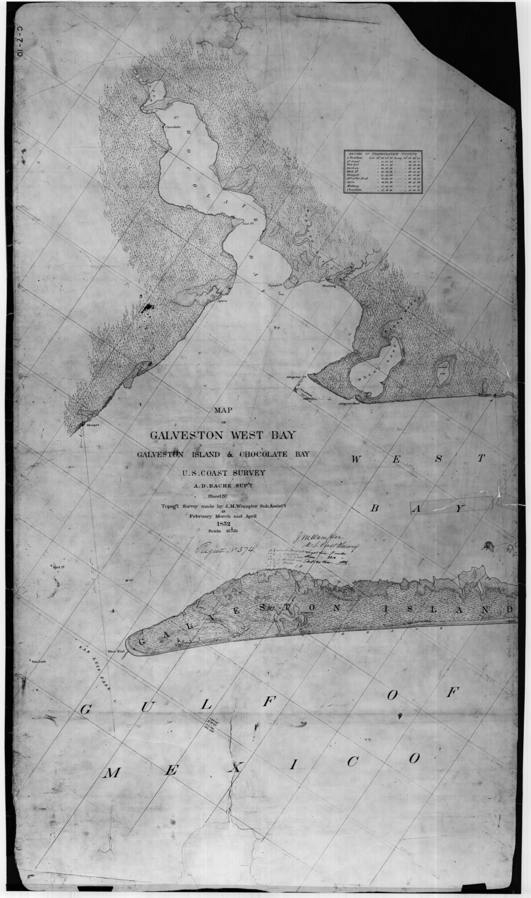
Map of Galveston West Bay, Galveston Island & Chocolate Bay
C-7-10
-
Map/Doc
69924
-
Collection
General Map Collection
-
Object Dates
1852 (Creation Date)
-
Counties
Galveston Brazoria
-
Subjects
Nautical Charts
-
Height x Width
50.5 x 29.9 inches
128.3 x 75.9 cm
-
Comments
Register No. 374
Part of: General Map Collection
Cottle County Sketch File 5

Print $6.00
- Digital $50.00
Cottle County Sketch File 5
1883
Size 17.0 x 9.6 inches
Map/Doc 19474
Nacogdoches County Sketch File 7

Print $6.00
- Digital $50.00
Nacogdoches County Sketch File 7
1875
Size 10.4 x 15.0 inches
Map/Doc 32250
Presidio County Rolled Sketch 46

Print $20.00
- Digital $50.00
Presidio County Rolled Sketch 46
1908
Size 19.0 x 15.5 inches
Map/Doc 7342
Hardeman County Sketch File 11

Print $42.00
- Digital $50.00
Hardeman County Sketch File 11
Size 9.2 x 9.1 inches
Map/Doc 25008
Frio County Rolled Sketch 12A

Print $20.00
- Digital $50.00
Frio County Rolled Sketch 12A
1948
Size 40.0 x 45.2 inches
Map/Doc 8905
Map of Lee County

Print $20.00
- Digital $50.00
Map of Lee County
1888
Size 42.1 x 39.8 inches
Map/Doc 16876
Hamilton County Rolled Sketch 3

Print $20.00
- Digital $50.00
Hamilton County Rolled Sketch 3
1919
Size 20.6 x 26.2 inches
Map/Doc 6070
Webb County Rolled Sketch 24

Print $20.00
- Digital $50.00
Webb County Rolled Sketch 24
1930
Size 33.0 x 23.0 inches
Map/Doc 8184
Gregg County Sketch File 4a

Print $4.00
- Digital $50.00
Gregg County Sketch File 4a
1848
Size 12.7 x 8.1 inches
Map/Doc 24572
Trinity County Sketch File 42

Print $60.00
- Digital $50.00
Trinity County Sketch File 42
1858
Size 28.0 x 37.6 inches
Map/Doc 10409
Haskell County Working Sketch 1

Print $40.00
- Digital $50.00
Haskell County Working Sketch 1
Size 31.0 x 74.5 inches
Map/Doc 66059
Brazoria County Sketch File 59

Print $364.00
- Digital $50.00
Brazoria County Sketch File 59
1996
Size 14.9 x 8.3 inches
Map/Doc 15398
You may also like
Orange County Sketch File 41

Print $40.00
- Digital $50.00
Orange County Sketch File 41
1918
Size 13.2 x 13.3 inches
Map/Doc 33381
Aransas County Sketch File 22

Print $34.00
- Digital $50.00
Aransas County Sketch File 22
1910
Size 14.8 x 9.1 inches
Map/Doc 13166
Briscoe County Sketch File O-1

Print $2.00
- Digital $50.00
Briscoe County Sketch File O-1
1935
Size 11.3 x 7.2 inches
Map/Doc 16425
Coke County Working Sketch 15

Print $20.00
- Digital $50.00
Coke County Working Sketch 15
1948
Size 25.7 x 21.7 inches
Map/Doc 68052
Reagan County

Print $40.00
- Digital $50.00
Reagan County
1915
Size 48.8 x 36.0 inches
Map/Doc 78429
[Plat of Texas and Pacific Railroad Company Block Lines, 80 Mile Reserve]
![3124, [Plat of Texas and Pacific Railroad Company Block Lines, 80 Mile Reserve], General Map Collection](https://historictexasmaps.com/wmedia_w700/maps/3124-1.tif.jpg)
Print $40.00
- Digital $50.00
[Plat of Texas and Pacific Railroad Company Block Lines, 80 Mile Reserve]
1876
Size 43.5 x 46.3 inches
Map/Doc 3124
Crockett County Working Sketch 10

Print $20.00
- Digital $50.00
Crockett County Working Sketch 10
1913
Size 23.5 x 21.6 inches
Map/Doc 68343
Kaufman County Working Sketch 7

Print $20.00
- Digital $50.00
Kaufman County Working Sketch 7
1984
Size 33.6 x 35.5 inches
Map/Doc 66670
Bowie County Working Sketch 3

Print $20.00
- Digital $50.00
Bowie County Working Sketch 3
1913
Size 25.5 x 17.1 inches
Map/Doc 67407
Tyler County Working Sketch 4

Print $20.00
- Digital $50.00
Tyler County Working Sketch 4
1926
Size 19.4 x 35.8 inches
Map/Doc 69474
Flight Mission No. CGI-3N, Frame 96, Cameron County

Print $20.00
- Digital $50.00
Flight Mission No. CGI-3N, Frame 96, Cameron County
1954
Size 18.5 x 22.1 inches
Map/Doc 84576
Eastland County Working Sketch Graphic Index

Print $20.00
- Digital $50.00
Eastland County Working Sketch Graphic Index
1945
Size 41.6 x 42.4 inches
Map/Doc 76529