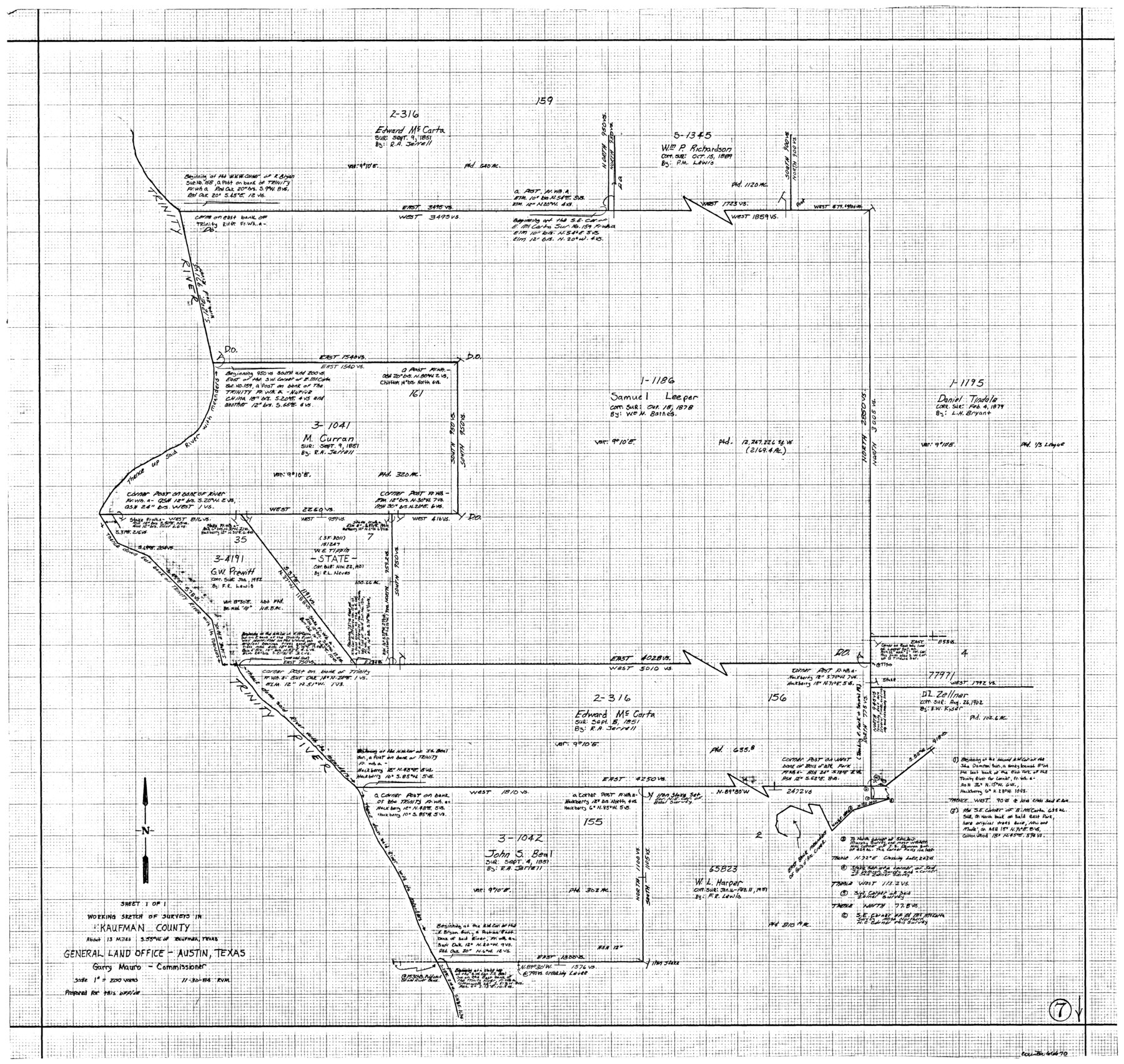
Kaufman County Working Sketch 7
-
Map/Doc
66670
-
Collection
General Map Collection
-
Object Dates
11/30/1984 (Creation Date)
-
People and Organizations
Rosendo V. Molina (Draftsman)
-
Counties
Kaufman
-
Subjects
Surveying Working Sketch
-
Height x Width
33.6 x 35.5 inches
85.3 x 90.2 cm
-
Scale
1" = 200 varas
Part of: General Map Collection
Bell County Sketch File 28

Print $4.00
- Digital $50.00
Bell County Sketch File 28
1870
Size 7.8 x 6.5 inches
Map/Doc 14437
[Sketch for Mineral Application 16700 - Pecos River Bed]
![2810, [Sketch for Mineral Application 16700 - Pecos River Bed], General Map Collection](https://historictexasmaps.com/wmedia_w700/maps/2810.tif.jpg)
Print $20.00
- Digital $50.00
[Sketch for Mineral Application 16700 - Pecos River Bed]
1927
Size 17.0 x 36.1 inches
Map/Doc 2810
Real County Rolled Sketch 10

Print $20.00
- Digital $50.00
Real County Rolled Sketch 10
Size 43.7 x 34.3 inches
Map/Doc 9835
Henderson County Working Sketch 28

Print $20.00
- Digital $50.00
Henderson County Working Sketch 28
1955
Size 27.3 x 24.9 inches
Map/Doc 66161
G. C. & S. F. Ry. Northern-Division, Alignment and Right of Way Map, Weatherford Branch, Johnson and Hood Counties, Texas

Print $40.00
- Digital $50.00
G. C. & S. F. Ry. Northern-Division, Alignment and Right of Way Map, Weatherford Branch, Johnson and Hood Counties, Texas
1935
Size 37.8 x 100.5 inches
Map/Doc 64649

Cass County Working Sketch 47b

Print $20.00
- Digital $50.00
Cass County Working Sketch 47b
1992
Size 32.3 x 36.4 inches
Map/Doc 76063
Maverick County Working Sketch 6

Print $40.00
- Digital $50.00
Maverick County Working Sketch 6
1944
Size 55.9 x 42.4 inches
Map/Doc 70898
Hays County Working Sketch 10

Print $20.00
- Digital $50.00
Hays County Working Sketch 10
1949
Size 23.4 x 25.8 inches
Map/Doc 66084
Sutton County Working Sketch 10

Print $40.00
- Digital $50.00
Sutton County Working Sketch 10
1972
Size 71.0 x 42.9 inches
Map/Doc 62353
Terrell County Working Sketch 25

Print $40.00
- Digital $50.00
Terrell County Working Sketch 25
1942
Size 41.9 x 49.1 inches
Map/Doc 62175
La Salle County Working Sketch 6

Print $20.00
- Digital $50.00
La Salle County Working Sketch 6
1918
Size 30.8 x 16.8 inches
Map/Doc 70307
You may also like

Liberty County Working Sketch 1

Print $20.00
- Digital $50.00
Liberty County Working Sketch 1
Size 26.5 x 29.7 inches
Map/Doc 70460
Pecos County Rolled Sketch 111

Print $20.00
- Digital $50.00
Pecos County Rolled Sketch 111
1941
Size 30.0 x 20.9 inches
Map/Doc 7256
Flight Mission No. BRA-6M, Frame 152, Jefferson County

Print $20.00
- Digital $50.00
Flight Mission No. BRA-6M, Frame 152, Jefferson County
1953
Size 18.6 x 22.3 inches
Map/Doc 85453
A New Map of Texas, Oregon and California with the regions adjoining, compiled from the most recent authorities

Print $20.00
- Digital $50.00
A New Map of Texas, Oregon and California with the regions adjoining, compiled from the most recent authorities
1846
Size 23.2 x 21.2 inches
Map/Doc 93872
Lavaca County Working Sketch 24

Print $20.00
- Digital $50.00
Lavaca County Working Sketch 24
1985
Size 29.5 x 35.7 inches
Map/Doc 70377
Tom Green Co.

Print $40.00
- Digital $50.00
Tom Green Co.
1887
Size 42.0 x 110.7 inches
Map/Doc 76034
Howard County, Texas

Print $20.00
- Digital $50.00
Howard County, Texas
1870
Size 22.7 x 17.9 inches
Map/Doc 733
Hill County Sketch File 8a

Print $4.00
- Digital $50.00
Hill County Sketch File 8a
1858
Size 10.2 x 8.1 inches
Map/Doc 26474
Nueces County Sketch File 24

Print $2.00
- Digital $50.00
Nueces County Sketch File 24
Size 8.7 x 14.0 inches
Map/Doc 32571
Cottle County Sketch File 1

Print $20.00
- Digital $50.00
Cottle County Sketch File 1
1882
Size 20.7 x 18.9 inches
Map/Doc 11189
Presidio County Boundary File 2

Print $8.00
- Digital $50.00
Presidio County Boundary File 2
Size 14.0 x 8.6 inches
Map/Doc 58054