Presidio County Boundary File 2
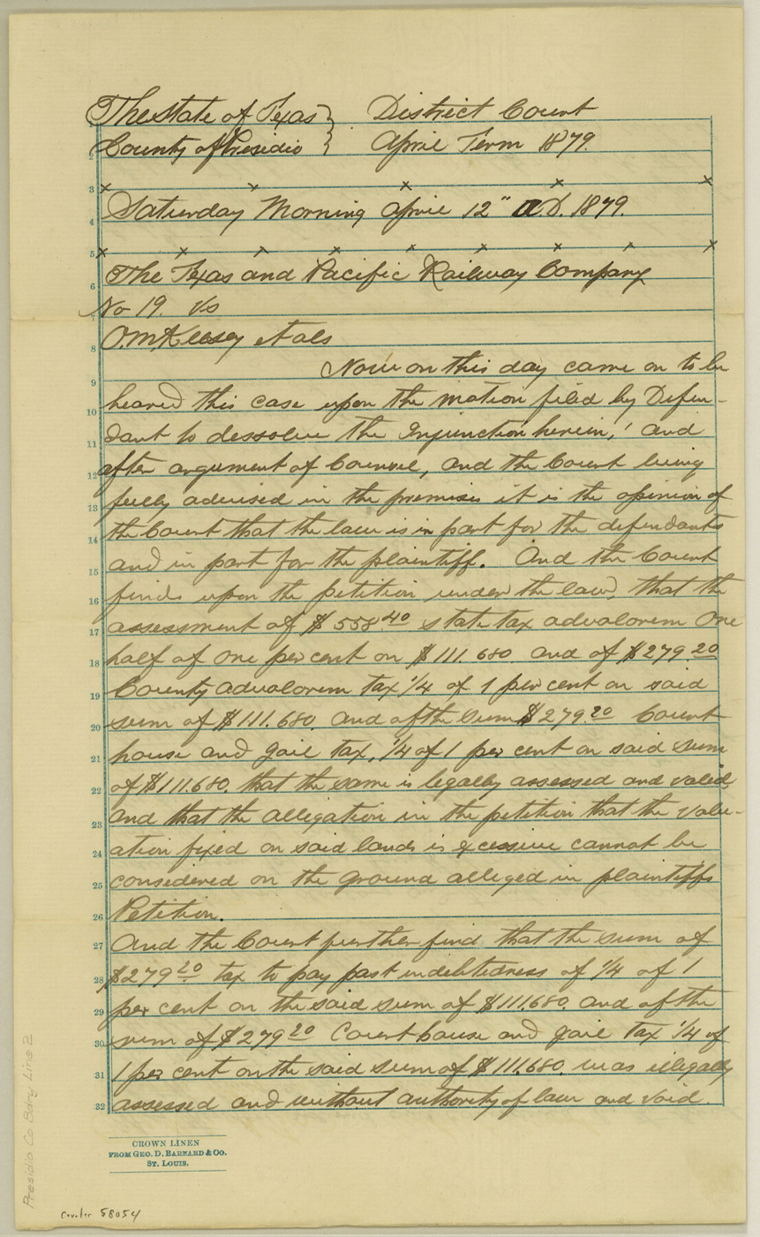
Copy of Decree of Court in reference to the Collection of Tax from the T. P. Ry. Co. in Presidio Co.
-
Map/Doc
58054
-
Collection
General Map Collection
-
Counties
Presidio
-
Subjects
County Boundaries
-
Height x Width
14.0 x 8.6 inches
35.6 x 21.8 cm
Part of: General Map Collection
Territory served by the Galveston Bay Ports, Tex.

Print $20.00
- Digital $50.00
Territory served by the Galveston Bay Ports, Tex.
1924
Size 17.1 x 16.0 inches
Map/Doc 97165
Lampasas County Working Sketch 11

Print $20.00
- Digital $50.00
Lampasas County Working Sketch 11
1964
Size 38.3 x 42.8 inches
Map/Doc 70288
Flight Mission No. DCL-3C, Frame 107, Kenedy County

Print $20.00
- Digital $50.00
Flight Mission No. DCL-3C, Frame 107, Kenedy County
1943
Size 18.6 x 22.4 inches
Map/Doc 85802
McMullen County Sketch File 36

Print $8.00
- Digital $50.00
McMullen County Sketch File 36
Size 4.8 x 8.2 inches
Map/Doc 31406
Map of the City of Austin Texas

Map of the City of Austin Texas
1933
Size 22.6 x 17.6 inches
Map/Doc 1685
Flight Mission No. DQO-11K, Frame 17, Galveston County

Print $20.00
- Digital $50.00
Flight Mission No. DQO-11K, Frame 17, Galveston County
1952
Size 18.7 x 22.4 inches
Map/Doc 85210
Frio County Sketch File 6

Print $32.00
- Digital $50.00
Frio County Sketch File 6
1883
Size 8.7 x 5.3 inches
Map/Doc 23118
Live Oak County Working Sketch 35

Print $20.00
- Digital $50.00
Live Oak County Working Sketch 35
2003
Size 36.4 x 34.7 inches
Map/Doc 82446
Township No. 4 South Range No. 17 West of the Indian Meridian

Print $20.00
- Digital $50.00
Township No. 4 South Range No. 17 West of the Indian Meridian
1875
Size 19.2 x 24.4 inches
Map/Doc 75164
Culberson County Sketch File 44

Print $57.00
- Digital $50.00
Culberson County Sketch File 44
1968
Size 11.4 x 8.9 inches
Map/Doc 20331
Johnson County Boundary File 3

Print $24.00
- Digital $50.00
Johnson County Boundary File 3
Size 11.3 x 8.7 inches
Map/Doc 55577
Zapata County Sketch File 1

Print $20.00
- Digital $50.00
Zapata County Sketch File 1
1875
Size 30.5 x 21.4 inches
Map/Doc 12717
You may also like
Fisher County Sketch File 8

Print $16.00
- Digital $50.00
Fisher County Sketch File 8
1898
Size 14.7 x 9.1 inches
Map/Doc 22567
Correct Map of Texas and Louisiana

Print $40.00
- Digital $50.00
Correct Map of Texas and Louisiana
1917
Size 41.6 x 53.6 inches
Map/Doc 2142
Hamilton County Boundary File 7

Print $32.00
- Digital $50.00
Hamilton County Boundary File 7
Size 17.6 x 11.4 inches
Map/Doc 54227
Flight Mission No. DQO-7K, Frame 111, Galveston County

Print $20.00
- Digital $50.00
Flight Mission No. DQO-7K, Frame 111, Galveston County
1952
Size 18.7 x 22.4 inches
Map/Doc 85126
Flight Mission No. DQN-2K, Frame 76, Calhoun County

Print $20.00
- Digital $50.00
Flight Mission No. DQN-2K, Frame 76, Calhoun County
1953
Size 18.8 x 22.3 inches
Map/Doc 84268
A Map of Austin's Colony and adjacent country in Texas drawn principally from actual survey by Stephen F. Austin

A Map of Austin's Colony and adjacent country in Texas drawn principally from actual survey by Stephen F. Austin
1820
Size 13.8 x 17.0 inches
Map/Doc 93353

Orange County Working Sketch 50

Print $20.00
- Digital $50.00
Orange County Working Sketch 50
1991
Size 36.0 x 43.6 inches
Map/Doc 71382
Stephens County

Print $20.00
- Digital $50.00
Stephens County
1940
Size 42.4 x 40.7 inches
Map/Doc 95644
Leon County Working Sketch 22

Print $20.00
- Digital $50.00
Leon County Working Sketch 22
1965
Size 27.9 x 31.1 inches
Map/Doc 70421
Travis County Boundary File 6a

Print $14.00
- Digital $50.00
Travis County Boundary File 6a
Size 11.5 x 9.0 inches
Map/Doc 59447
