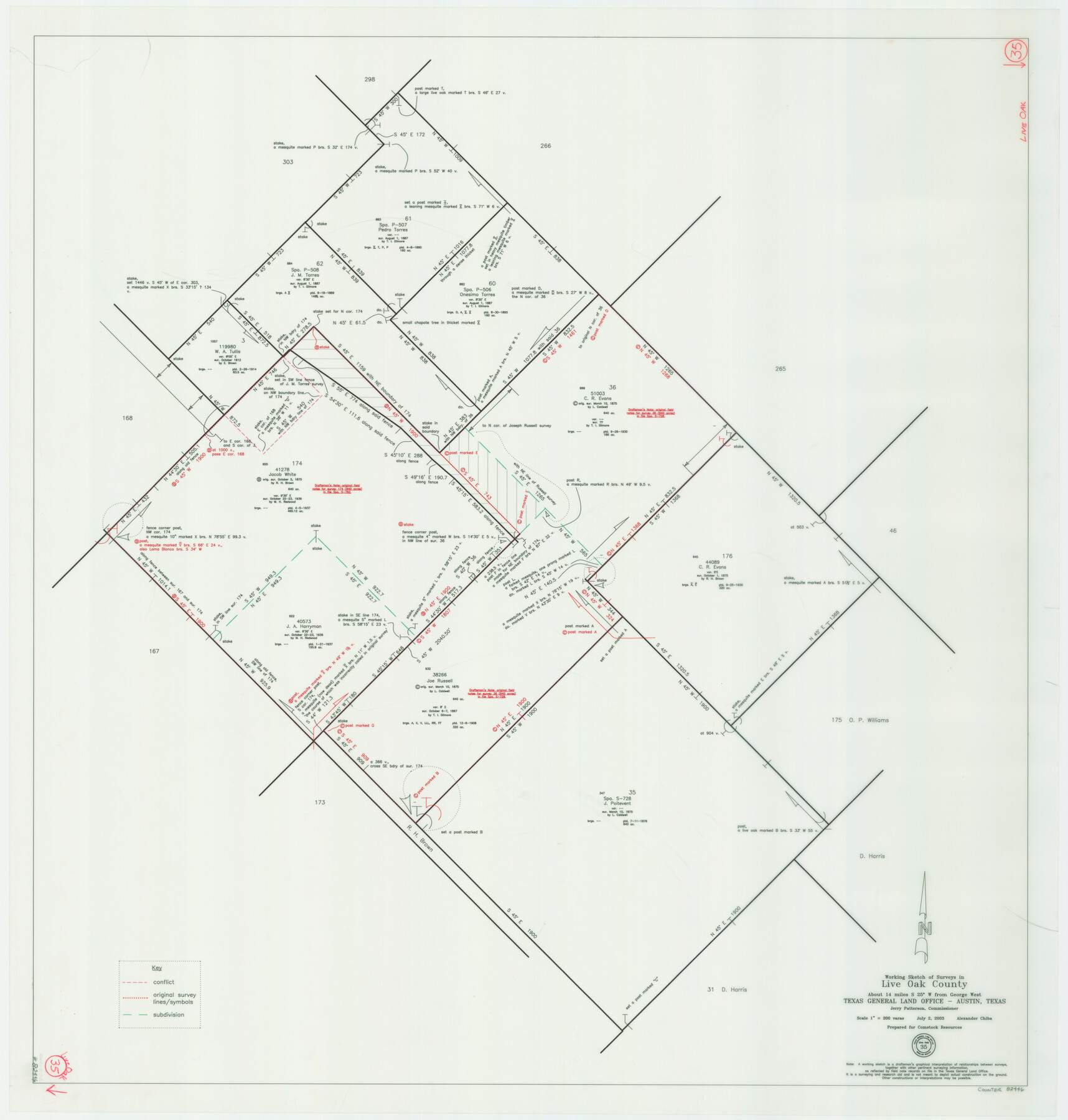
Live Oak County Working Sketch 35
-
Map/Doc
82446
-
Collection
General Map Collection
-
Object Dates
7/2/2003 (Creation Date)
-
People and Organizations
Jerry E. Patterson (GLO Commissioner)
Alex Chiba (Draftsman)
-
Counties
Live Oak
-
Subjects
Surveying Working Sketch
-
Height x Width
36.4 x 34.7 inches
92.5 x 88.1 cm
-
Scale
1" = 200 varas
Part of: General Map Collection
Travis County Working Sketch 6

Print $20.00
- Digital $50.00
Travis County Working Sketch 6
1913
Size 28.9 x 20.6 inches
Map/Doc 69390
Live Oak County Sketch File 6

Print $4.00
- Digital $50.00
Live Oak County Sketch File 6
1847
Size 9.9 x 7.8 inches
Map/Doc 30257
Crosby County

Print $20.00
- Digital $50.00
Crosby County
1927
Size 41.1 x 36.7 inches
Map/Doc 73123
San Augustine County Working Sketch 6

Print $20.00
- Digital $50.00
San Augustine County Working Sketch 6
1935
Size 22.2 x 37.9 inches
Map/Doc 63693
[Sketch for Mineral Application 26501 - Sabine River, T. A. Oldhausen]
![2843, [Sketch for Mineral Application 26501 - Sabine River, T. A. Oldhausen], General Map Collection](https://historictexasmaps.com/wmedia_w700/maps/2843.tif.jpg)
Print $20.00
- Digital $50.00
[Sketch for Mineral Application 26501 - Sabine River, T. A. Oldhausen]
1931
Size 23.8 x 36.2 inches
Map/Doc 2843
Travis County Appraisal District Plat Map 2_0803

Print $20.00
- Digital $50.00
Travis County Appraisal District Plat Map 2_0803
Size 21.5 x 26.4 inches
Map/Doc 94239
Flight Mission No. CUG-3P, Frame 35, Kleberg County

Print $20.00
- Digital $50.00
Flight Mission No. CUG-3P, Frame 35, Kleberg County
1956
Size 18.6 x 22.3 inches
Map/Doc 86240
Brazoria County Sketch File 24

Print $6.00
- Digital $50.00
Brazoria County Sketch File 24
1868
Size 11.3 x 10.4 inches
Map/Doc 15022
Webb County Rolled Sketch 52

Print $20.00
- Digital $50.00
Webb County Rolled Sketch 52
1943
Size 37.8 x 29.3 inches
Map/Doc 8205
McMullen County Working Sketch 34

Print $20.00
- Digital $50.00
McMullen County Working Sketch 34
1959
Size 25.9 x 26.0 inches
Map/Doc 70735
Flight Mission No. BRA-16M, Frame 102, Jefferson County

Print $20.00
- Digital $50.00
Flight Mission No. BRA-16M, Frame 102, Jefferson County
1953
Size 18.6 x 22.3 inches
Map/Doc 85714
United States - Gulf Coast - Padre I. and Laguna Madre Lat. 27° 12' to Lat. 26° 33' Texas

Print $20.00
- Digital $50.00
United States - Gulf Coast - Padre I. and Laguna Madre Lat. 27° 12' to Lat. 26° 33' Texas
1913
Size 27.1 x 18.3 inches
Map/Doc 72816
You may also like
Brewster County Working Sketch 11

Print $20.00
- Digital $50.00
Brewster County Working Sketch 11
1919
Size 18.2 x 17.9 inches
Map/Doc 67544
Brazos River, Brazos River Sheet 4

Print $20.00
- Digital $50.00
Brazos River, Brazos River Sheet 4
1926
Size 19.4 x 32.1 inches
Map/Doc 69668
Comanche County Working Sketch 11

Print $20.00
- Digital $50.00
Comanche County Working Sketch 11
1955
Size 31.7 x 43.3 inches
Map/Doc 68145
Sketch Showing Boundary Between Randall and Deaf Smith Counties

Print $20.00
- Digital $50.00
Sketch Showing Boundary Between Randall and Deaf Smith Counties
Size 13.4 x 33.3 inches
Map/Doc 91832
Brazoria County Sketch File 21

Print $4.00
- Digital $50.00
Brazoria County Sketch File 21
Size 8.3 x 7.5 inches
Map/Doc 15016
Chambers County Sketch File 25

Print $8.00
- Digital $50.00
Chambers County Sketch File 25
Size 14.1 x 8.7 inches
Map/Doc 17602
Brewster County Rolled Sketch 124

Print $20.00
- Digital $50.00
Brewster County Rolled Sketch 124
1975
Size 15.8 x 13.2 inches
Map/Doc 5299
[Galveston, Harrisburg & San Antonio from El Paso-Presidio county boundary to Presidio-Pecos county boundary]
![64716, [Galveston, Harrisburg & San Antonio from El Paso-Presidio county boundary to Presidio-Pecos county boundary], General Map Collection](https://historictexasmaps.com/wmedia_w700/maps/64716.tif.jpg)
Print $40.00
- Digital $50.00
[Galveston, Harrisburg & San Antonio from El Paso-Presidio county boundary to Presidio-Pecos county boundary]
Size 124.4 x 45.3 inches
Map/Doc 64716
Hardin County Working Sketch 20

Print $20.00
- Digital $50.00
Hardin County Working Sketch 20
1947
Size 38.1 x 32.6 inches
Map/Doc 63418
Coryell County Rolled Sketch 2

Print $20.00
- Digital $50.00
Coryell County Rolled Sketch 2
1951
Size 15.7 x 19.1 inches
Map/Doc 5566
Terrell County Rolled Sketch 46

Print $20.00
- Digital $50.00
Terrell County Rolled Sketch 46
1958
Size 16.1 x 14.6 inches
Map/Doc 7948
Hutchinson County Rolled Sketch 23

Print $20.00
- Digital $50.00
Hutchinson County Rolled Sketch 23
1913
Size 29.7 x 25.6 inches
Map/Doc 6288