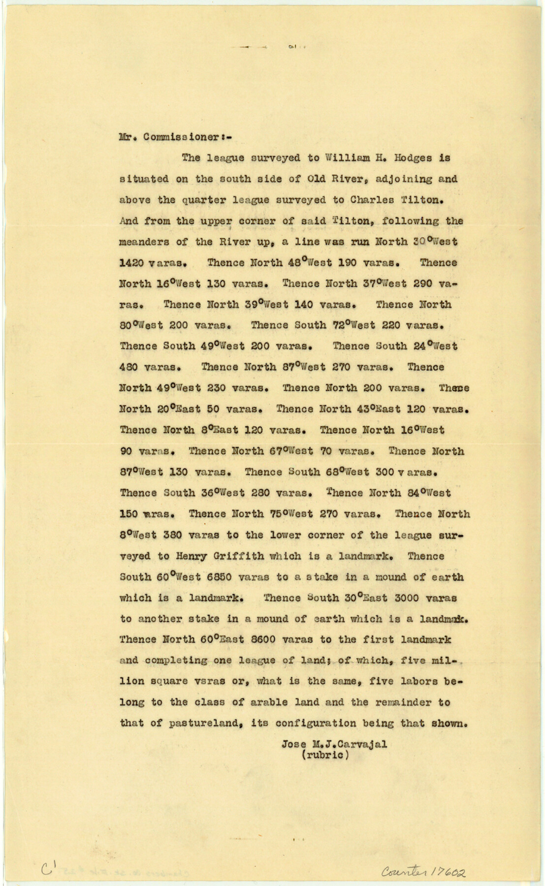
Chambers County Sketch File 25
[Translations of Titles of Wm. Bloodgood, Wm. H. Hodges, and Henry Griffith grants]
-
Map/Doc
17602
-
Collection
General Map Collection
-
Counties
Chambers
-
Subjects
Surveying Sketch File
-
Height x Width
14.1 x 8.7 inches
35.8 x 22.1 cm
-
Medium
paper, print
-
Features
Old River
Cedar Creek
San Jacinto Bay
Part of: General Map Collection
Current Miscellaneous File 8

Print $10.00
- Digital $50.00
Current Miscellaneous File 8
Size 14.6 x 9.1 inches
Map/Doc 73736
Sketch of coast of Texas, Laguna Madre from Pt. of Rocks to Corpus Christi [and accompanying letter]
![72964, Sketch of coast of Texas, Laguna Madre from Pt. of Rocks to Corpus Christi [and accompanying letter], General Map Collection](https://historictexasmaps.com/wmedia_w700/maps/72964.tif.jpg)
Print $2.00
- Digital $50.00
Sketch of coast of Texas, Laguna Madre from Pt. of Rocks to Corpus Christi [and accompanying letter]
Size 11.2 x 8.8 inches
Map/Doc 72964
Harris County Historic Topographic 29

Print $20.00
- Digital $50.00
Harris County Historic Topographic 29
1915
Size 29.1 x 23.0 inches
Map/Doc 65840
Flight Mission No. BRE-1P, Frame 73, Nueces County

Print $20.00
- Digital $50.00
Flight Mission No. BRE-1P, Frame 73, Nueces County
1956
Size 18.5 x 22.4 inches
Map/Doc 86655
Reagan County Sketch File 1

Print $20.00
- Digital $50.00
Reagan County Sketch File 1
1914
Size 24.3 x 30.3 inches
Map/Doc 12210
Flight Mission No. CLL-1N, Frame 77, Willacy County

Print $20.00
- Digital $50.00
Flight Mission No. CLL-1N, Frame 77, Willacy County
1954
Size 18.4 x 22.1 inches
Map/Doc 87023
Jasper County Sketch File 33

Print $20.00
- Digital $50.00
Jasper County Sketch File 33
1938
Size 23.0 x 17.6 inches
Map/Doc 11854
St. Louis, Brownsville & Mexico Railway Location Map from Mile 40 to Mile 60

Print $40.00
- Digital $50.00
St. Louis, Brownsville & Mexico Railway Location Map from Mile 40 to Mile 60
1905
Size 20.3 x 136.1 inches
Map/Doc 89282
Montgomery County Rolled Sketch 10

Print $20.00
- Digital $50.00
Montgomery County Rolled Sketch 10
1905
Size 35.5 x 26.2 inches
Map/Doc 6796
Calhoun County Rolled Sketch 15

Print $20.00
- Digital $50.00
Calhoun County Rolled Sketch 15
Size 34.4 x 42.6 inches
Map/Doc 8548
Report of a resurvey of Texas & Pacific Ry. Lands in the 80 mile reservation made in 1930-31 for Kloh, Rumsey, and Abrams by W. J. Powell, Consulting Eng.

Print $77.00
- Digital $50.00
Report of a resurvey of Texas & Pacific Ry. Lands in the 80 mile reservation made in 1930-31 for Kloh, Rumsey, and Abrams by W. J. Powell, Consulting Eng.
1931
Size 11.3 x 8.8 inches
Map/Doc 2247
Flight Mission No. BRA-16M, Frame 67, Jefferson County

Print $20.00
- Digital $50.00
Flight Mission No. BRA-16M, Frame 67, Jefferson County
1953
Size 18.6 x 22.4 inches
Map/Doc 85684
You may also like
United States - Gulf Coast - From Latitude 26° 33' to the Rio Grande Texas

Print $20.00
- Digital $50.00
United States - Gulf Coast - From Latitude 26° 33' to the Rio Grande Texas
1918
Size 27.6 x 18.1 inches
Map/Doc 72849
Leon County Rolled Sketch 35

Print $20.00
- Digital $50.00
Leon County Rolled Sketch 35
2018
Size 30.7 x 21.3 inches
Map/Doc 95288
Flight Mission No. DQN-2K, Frame 139, Calhoun County

Print $20.00
- Digital $50.00
Flight Mission No. DQN-2K, Frame 139, Calhoun County
1953
Size 16.3 x 16.2 inches
Map/Doc 84308

Shelby County Rolled Sketch 5

Print $20.00
- Digital $50.00
Shelby County Rolled Sketch 5
1942
Size 37.9 x 43.7 inches
Map/Doc 9921
Bandera County Working Sketch 24

Print $20.00
- Digital $50.00
Bandera County Working Sketch 24
1950
Size 31.6 x 33.0 inches
Map/Doc 67620
Stephens County Working Sketch 10

Print $40.00
- Digital $50.00
Stephens County Working Sketch 10
1921
Size 36.1 x 64.1 inches
Map/Doc 63953
Reagan County Sketch File 9

Print $20.00
- Digital $50.00
Reagan County Sketch File 9
1928
Size 27.0 x 22.3 inches
Map/Doc 12216
[Sketch of surveys in Val Verde County]
![5048, [Sketch of surveys in Val Verde County], Maddox Collection](https://historictexasmaps.com/wmedia_w700/maps/5048.tif.jpg)
Print $20.00
- Digital $50.00
[Sketch of surveys in Val Verde County]
Size 17.3 x 17.1 inches
Map/Doc 5048
Nolan County Sketch File 14

Print $20.00
- Digital $50.00
Nolan County Sketch File 14
1927
Size 32.6 x 20.0 inches
Map/Doc 42164
[Notes and rough sketch of survey 6, Block 16 and survey 19 1/2, Block 19]
![93052, [Notes and rough sketch of survey 6, Block 16 and survey 19 1/2, Block 19], Twichell Survey Records](https://historictexasmaps.com/wmedia_w700/maps/93052-1.tif.jpg)
Print $2.00
- Digital $50.00
[Notes and rough sketch of survey 6, Block 16 and survey 19 1/2, Block 19]
1937
Size 8.7 x 11.4 inches
Map/Doc 93052
[Atchison, Topeka & Santa Fe from Paisano to south of Plata]
![64709, [Atchison, Topeka & Santa Fe from Paisano to south of Plata], General Map Collection](https://historictexasmaps.com/wmedia_w700/maps/64709.tif.jpg)
Print $40.00
- Digital $50.00
[Atchison, Topeka & Santa Fe from Paisano to south of Plata]
Size 32.3 x 120.8 inches
Map/Doc 64709