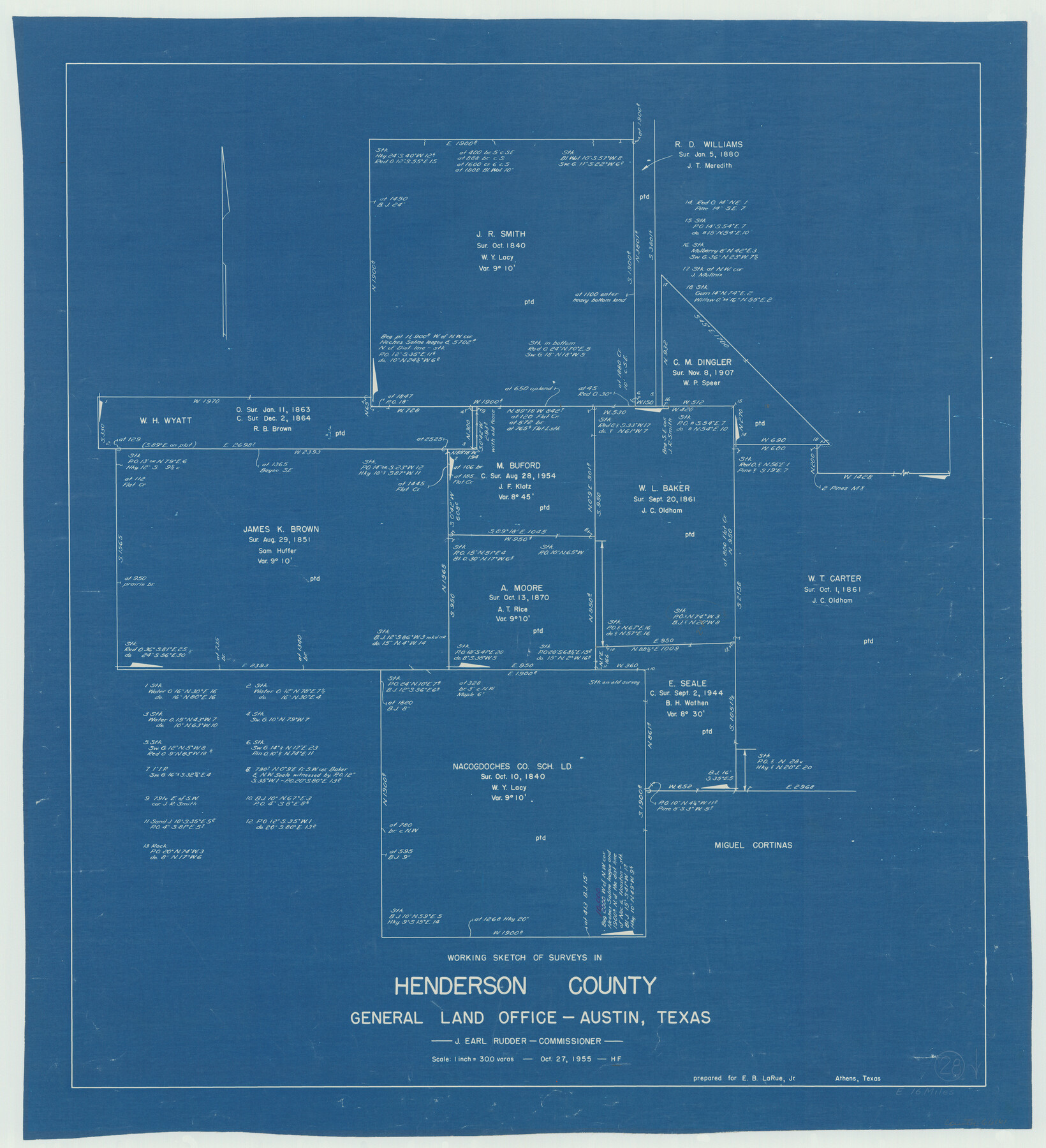
Henderson County Working Sketch 28
-
Map/Doc
66161
-
Collection
General Map Collection
-
Object Dates
10/27/1955 (Creation Date)
-
People and Organizations
Herman Forbes (Draftsman)
-
Counties
Henderson
-
Subjects
Surveying Working Sketch
-
Height x Width
27.3 x 24.9 inches
69.3 x 63.3 cm
-
Scale
1" = 300 varas
Part of: General Map Collection
Galveston Bay and Approaches

Print $20.00
- Digital $50.00
Galveston Bay and Approaches
1957
Size 43.6 x 32.7 inches
Map/Doc 69877
Old Miscellaneous File 14

Print $4.00
- Digital $50.00
Old Miscellaneous File 14
1898
Size 11.2 x 8.6 inches
Map/Doc 75449

Throckmorton County Boundary File 4

Print $6.00
- Digital $50.00
Throckmorton County Boundary File 4
Size 14.3 x 8.8 inches
Map/Doc 59283
Colorado County Sketch File 29

Print $6.00
- Digital $50.00
Colorado County Sketch File 29
1842
Size 11.2 x 9.0 inches
Map/Doc 18974
Glasscock County Boundary File 2

Print $14.00
- Digital $50.00
Glasscock County Boundary File 2
Size 14.4 x 9.1 inches
Map/Doc 53790
Garza County Rolled Sketch 13

Print $26.00
- Digital $50.00
Garza County Rolled Sketch 13
1935
Size 45.5 x 36.7 inches
Map/Doc 9047
Henderson County Boundary File 43

Print $28.00
- Digital $50.00
Henderson County Boundary File 43
Size 5.0 x 8.3 inches
Map/Doc 54708
Sketch Showing Beach Groins 6th St to 39th St - Galveston, Tex.

Print $20.00
- Digital $50.00
Sketch Showing Beach Groins 6th St to 39th St - Galveston, Tex.
1928
Size 21.0 x 36.4 inches
Map/Doc 73626
Harris County Historic Topographic 31

Print $20.00
- Digital $50.00
Harris County Historic Topographic 31
1915
Size 29.2 x 22.7 inches
Map/Doc 65842
Flight Mission No. CGI-3N, Frame 176, Cameron County

Print $20.00
- Digital $50.00
Flight Mission No. CGI-3N, Frame 176, Cameron County
1954
Size 18.6 x 22.4 inches
Map/Doc 84640
Cameron County Working Sketch 1

Print $20.00
- Digital $50.00
Cameron County Working Sketch 1
Size 42.8 x 30.1 inches
Map/Doc 67880
You may also like

Stephens County Sketch File 24

Print $5.00
- Digital $50.00
Stephens County Sketch File 24
1952
Size 24.5 x 32.5 inches
Map/Doc 12354
Howard County Sketch File 8

Print $3.00
- Digital $50.00
Howard County Sketch File 8
Size 20.8 x 18.7 inches
Map/Doc 11796
Westliches - Nordamerica

Print $20.00
- Digital $50.00
Westliches - Nordamerica
1867
Size 25.3 x 20.7 inches
Map/Doc 93753
Maps of Gulf Intracoastal Waterway, Texas - Sabine River to the Rio Grande and connecting waterways including ship channels

Print $20.00
- Digital $50.00
Maps of Gulf Intracoastal Waterway, Texas - Sabine River to the Rio Grande and connecting waterways including ship channels
1966
Size 14.5 x 22.3 inches
Map/Doc 61949

Nacogdoches County Working Sketch 4

Print $20.00
- Digital $50.00
Nacogdoches County Working Sketch 4
1946
Size 22.2 x 23.2 inches
Map/Doc 71220
McMullen County Working Sketch 53

Print $20.00
- Digital $50.00
McMullen County Working Sketch 53
1983
Size 18.1 x 18.7 inches
Map/Doc 70754
West Half - Brown County

Print $40.00
- Digital $50.00
West Half - Brown County
1982
Size 142.2 x 37.3 inches
Map/Doc 97384
Map of Fort Bend County

Print $20.00
- Digital $50.00
Map of Fort Bend County
1839
Size 19.0 x 26.9 inches
Map/Doc 3549
McMullen County Working Sketch 29

Print $40.00
- Digital $50.00
McMullen County Working Sketch 29
1956
Size 59.0 x 37.2 inches
Map/Doc 70730
