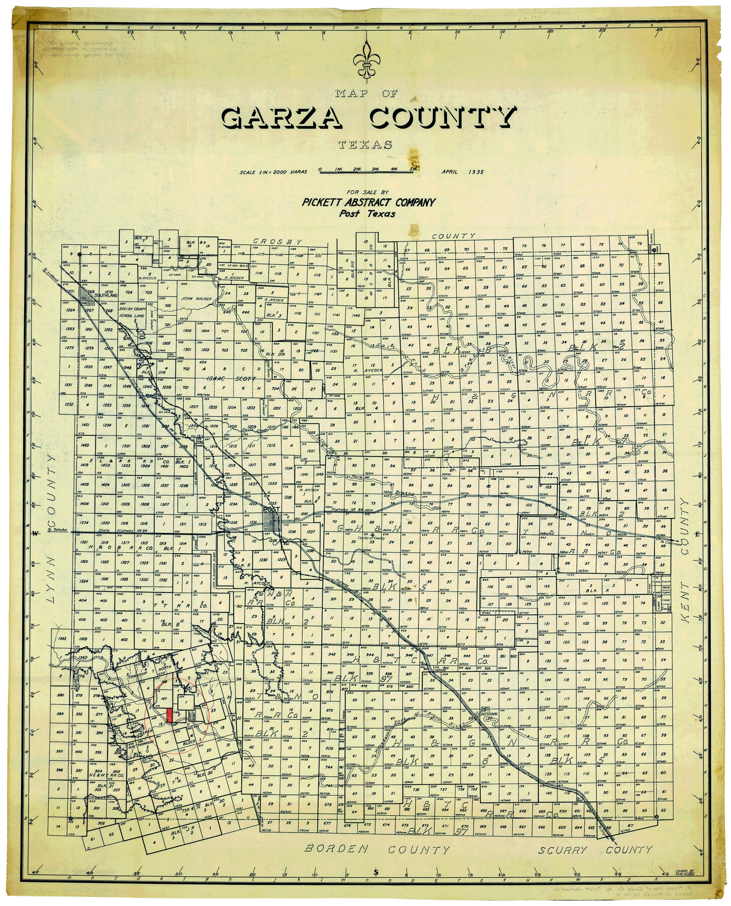
Garza County Rolled Sketch 13
Map of Garza County, Texas [and accompanying correspondence]
-
Map/Doc
9047
-
Collection
General Map Collection
-
Object Dates
1935 (Creation Date)
-
Counties
Garza
-
Subjects
Surveying Rolled Sketch
-
Height x Width
45.5 x 36.7 inches
115.6 x 93.2 cm
-
Medium
multi-page, multi-format
Part of: General Map Collection
[Surveys in the Bexar District along the Cibolo Creek]
![98, [Surveys in the Bexar District along the Cibolo Creek], General Map Collection](https://historictexasmaps.com/wmedia_w700/maps/98.tif.jpg)
Print $2.00
- Digital $50.00
[Surveys in the Bexar District along the Cibolo Creek]
1847
Size 13.0 x 7.4 inches
Map/Doc 98
Somervell County Working Sketch 2

Print $20.00
- Digital $50.00
Somervell County Working Sketch 2
1951
Size 22.4 x 23.8 inches
Map/Doc 63906
La Salle County Sketch File 34

Print $6.00
- Digital $50.00
La Salle County Sketch File 34
Size 15.8 x 9.5 inches
Map/Doc 29585
Jones County Sketch File 20

Print $4.00
- Digital $50.00
Jones County Sketch File 20
1875
Size 14.2 x 8.8 inches
Map/Doc 28543
Red River County Rolled Sketch 9

Print $20.00
- Digital $50.00
Red River County Rolled Sketch 9
Size 27.1 x 18.1 inches
Map/Doc 7475
Presidio County Rolled Sketch 137

Print $20.00
- Digital $50.00
Presidio County Rolled Sketch 137
1999
Size 38.7 x 47.9 inches
Map/Doc 8352
Nueces County Sketch File 25B

Print $20.00
- Digital $50.00
Nueces County Sketch File 25B
1894
Size 17.6 x 24.6 inches
Map/Doc 42183
Colorado County Sketch File 6

Print $8.00
- Digital $50.00
Colorado County Sketch File 6
1860
Size 8.4 x 7.0 inches
Map/Doc 18921
Maverick County Rolled Sketch 20

Print $20.00
- Digital $50.00
Maverick County Rolled Sketch 20
Size 24.5 x 38.7 inches
Map/Doc 6712
El Paso County State Real Property Sketch 4

Print $20.00
- Digital $50.00
El Paso County State Real Property Sketch 4
2012
Size 29.9 x 35.9 inches
Map/Doc 93701
Terrell County Working Sketch 53

Print $40.00
- Digital $50.00
Terrell County Working Sketch 53
1958
Size 61.9 x 39.7 inches
Map/Doc 62146
Real County Working Sketch 19

Print $3.00
- Digital $50.00
Real County Working Sketch 19
1944
Size 12.0 x 10.4 inches
Map/Doc 71911
You may also like
Oldham County Rolled Sketch 2

Print $40.00
- Digital $50.00
Oldham County Rolled Sketch 2
1886
Size 35.7 x 55.1 inches
Map/Doc 9639
Duval County Boundary File 3

Print $14.00
- Digital $50.00
Duval County Boundary File 3
Size 8.6 x 3.9 inches
Map/Doc 52719
Flight Mission No. DQO-1K, Frame 92, Galveston County

Print $20.00
- Digital $50.00
Flight Mission No. DQO-1K, Frame 92, Galveston County
1952
Size 18.9 x 22.6 inches
Map/Doc 84988
Refugio County Sketch File 2

Print $6.00
- Digital $50.00
Refugio County Sketch File 2
1846
Size 12.6 x 7.7 inches
Map/Doc 35238
Real County Rolled Sketch 18

Print $20.00
- Digital $50.00
Real County Rolled Sketch 18
Size 22.0 x 28.0 inches
Map/Doc 7463
Flight Mission No. DQO-3K, Frame 39, Galveston County

Print $20.00
- Digital $50.00
Flight Mission No. DQO-3K, Frame 39, Galveston County
1952
Size 18.8 x 22.5 inches
Map/Doc 85080
[Sketch for Mineral Application 16700 - Pecos River Bed]
![2809, [Sketch for Mineral Application 16700 - Pecos River Bed], General Map Collection](https://historictexasmaps.com/wmedia_w700/maps/2809.tif.jpg)
Print $20.00
- Digital $50.00
[Sketch for Mineral Application 16700 - Pecos River Bed]
1927
Size 14.8 x 30.8 inches
Map/Doc 2809
Texas Highway Map Points of Interest, Recreational Facilities Guide, Special Events Calendar [Verso]
![94188, Texas Highway Map Points of Interest, Recreational Facilities Guide, Special Events Calendar [Verso], General Map Collection](https://historictexasmaps.com/wmedia_w700/maps/94188.tif.jpg)
Texas Highway Map Points of Interest, Recreational Facilities Guide, Special Events Calendar [Verso]
1963
Size 31.0 x 18.3 inches
Map/Doc 94188
Map of Rains County

Print $20.00
- Digital $50.00
Map of Rains County
1873
Size 12.0 x 12.4 inches
Map/Doc 4619
San Patricio County Rolled Sketch 46C

Print $3.00
- Digital $50.00
San Patricio County Rolled Sketch 46C
1983
Size 11.0 x 17.5 inches
Map/Doc 8374
Angelina County Sketch File 15d

Print $20.00
- Digital $50.00
Angelina County Sketch File 15d
1863
Size 8.0 x 6.6 inches
Map/Doc 12980
Flight Mission No. CUG-3P, Frame 135, Kleberg County

Print $20.00
- Digital $50.00
Flight Mission No. CUG-3P, Frame 135, Kleberg County
1956
Size 18.7 x 22.3 inches
Map/Doc 86270