Refugio County Sketch File 2
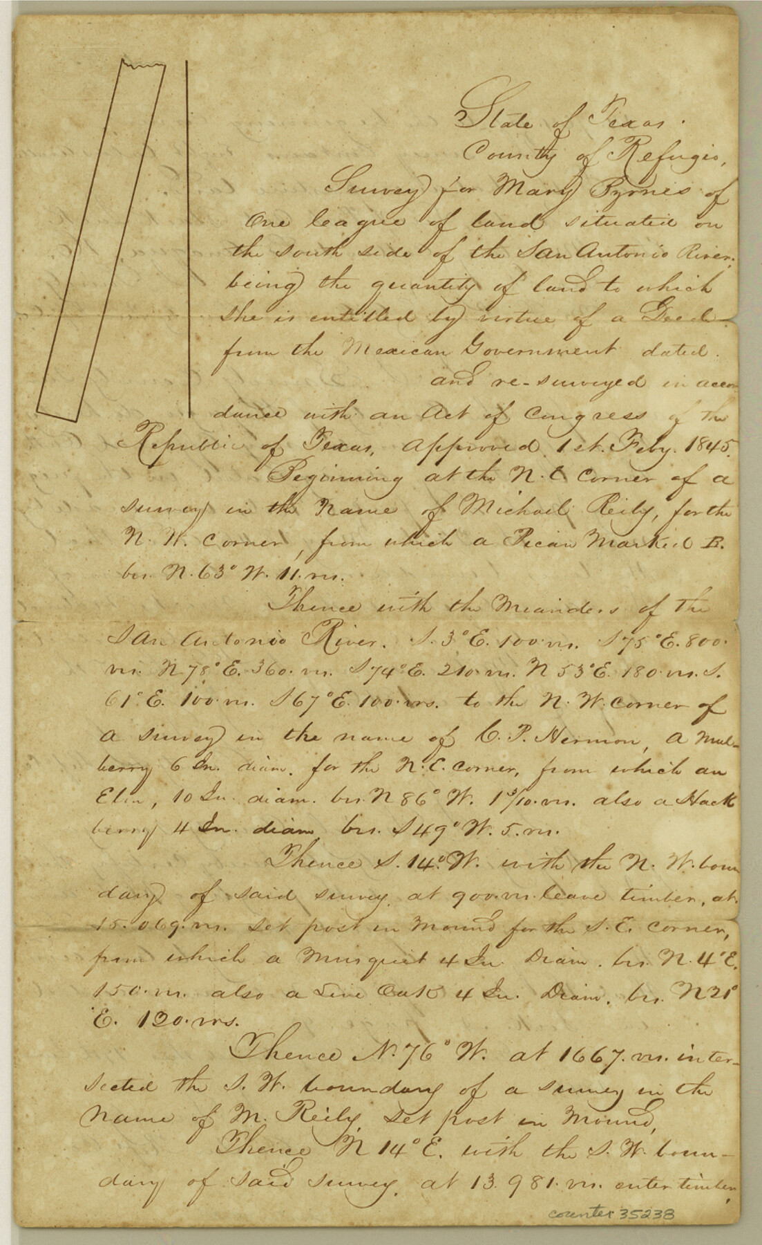
[Field notes of a survey of one league for Mary Byrne situated northeast of Refugio on the south bank of the San Antonio River]
-
Map/Doc
35238
-
Collection
General Map Collection
-
Object Dates
6/5/1846 (Creation Date)
1846 (File Date)
5/22/1846 (Survey Date)
-
People and Organizations
J. Snively (Surveyor/Engineer)
George Gentry (Chainman/Field Personnel)
M.L. Byrnes (Chainman/Field Personnel)
-
Counties
Refugio
-
Subjects
Surveying Sketch File
-
Height x Width
12.6 x 7.7 inches
32.0 x 19.6 cm
-
Medium
paper, manuscript
-
Features
San Antonio River
Part of: General Map Collection
Galveston County NRC Article 33.136 Sketch 62

Print $28.00
- Digital $50.00
Galveston County NRC Article 33.136 Sketch 62
2009
Size 24.0 x 36.0 inches
Map/Doc 94596
Map of a part of Fisher and Miller's Colony - Harvey's District

Print $20.00
- Digital $50.00
Map of a part of Fisher and Miller's Colony - Harvey's District
1856
Size 15.2 x 19.8 inches
Map/Doc 1972
Flight Mission No. DQO-11K, Frame 17, Galveston County

Print $20.00
- Digital $50.00
Flight Mission No. DQO-11K, Frame 17, Galveston County
1952
Size 18.7 x 22.4 inches
Map/Doc 85210
Right of Way and Track Map International & Gt Northern Ry. operated by the International & Gt. Northern Ry. Co., San Antonio Division

Print $40.00
- Digital $50.00
Right of Way and Track Map International & Gt Northern Ry. operated by the International & Gt. Northern Ry. Co., San Antonio Division
1917
Size 26.2 x 58.6 inches
Map/Doc 64788
Montague County Sketch File 14

Print $4.00
- Digital $50.00
Montague County Sketch File 14
1880
Size 7.8 x 5.4 inches
Map/Doc 31740
Val Verde County Working Sketch 121

Print $40.00
- Digital $50.00
Val Verde County Working Sketch 121
2005
Size 34.0 x 54.2 inches
Map/Doc 83590
Montgomery County Working Sketch 11

Print $20.00
- Digital $50.00
Montgomery County Working Sketch 11
1933
Size 25.2 x 17.7 inches
Map/Doc 71118
McCulloch County Sketch File 12

Print $6.00
- Digital $50.00
McCulloch County Sketch File 12
1989
Size 14.2 x 8.6 inches
Map/Doc 31198
Rusk County Sketch File 45

Print $8.00
Rusk County Sketch File 45
1959
Size 11.3 x 8.8 inches
Map/Doc 35591
Galveston County Sketch File 38

Print $8.00
- Digital $50.00
Galveston County Sketch File 38
1908
Size 6.8 x 7.8 inches
Map/Doc 23441
Kimble County Working Sketch 42

Print $20.00
- Digital $50.00
Kimble County Working Sketch 42
1949
Size 40.5 x 40.0 inches
Map/Doc 70110
Right of Way Map Fort Worth & Denver City Railroad through Hardeman County

Print $40.00
- Digital $50.00
Right of Way Map Fort Worth & Denver City Railroad through Hardeman County
1885
Size 23.8 x 121.2 inches
Map/Doc 64424
You may also like
Palo Pinto County Rolled Sketch 5

Print $40.00
- Digital $50.00
Palo Pinto County Rolled Sketch 5
1917
Size 53.8 x 35.8 inches
Map/Doc 76022
Travis County Rolled Sketch 25

Print $20.00
- Digital $50.00
Travis County Rolled Sketch 25
1942
Size 22.1 x 29.2 inches
Map/Doc 8026
Kimble County Sketch File 3

Print $4.00
- Digital $50.00
Kimble County Sketch File 3
1847
Size 9.1 x 11.5 inches
Map/Doc 28910
[H. & G. N. Blocks 1-4 and Blocks C-19, C-20, 54, 55 and 56]
![91781, [H. & G. N. Blocks 1-4 and Blocks C-19, C-20, 54, 55 and 56], Twichell Survey Records](https://historictexasmaps.com/wmedia_w700/maps/91781-1.tif.jpg)
Print $20.00
- Digital $50.00
[H. & G. N. Blocks 1-4 and Blocks C-19, C-20, 54, 55 and 56]
Size 23.3 x 29.3 inches
Map/Doc 91781
[Sketch for Mineral Application 24072, San Jacinto River]
![65603, [Sketch for Mineral Application 24072, San Jacinto River], General Map Collection](https://historictexasmaps.com/wmedia_w700/maps/65603.tif.jpg)
Print $20.00
- Digital $50.00
[Sketch for Mineral Application 24072, San Jacinto River]
1929
Size 23.4 x 17.6 inches
Map/Doc 65603
Flight Mission No. BRA-16M, Frame 106, Jefferson County

Print $20.00
- Digital $50.00
Flight Mission No. BRA-16M, Frame 106, Jefferson County
1953
Size 18.6 x 22.3 inches
Map/Doc 85718
Medina County Rolled Sketch 6

Print $40.00
- Digital $50.00
Medina County Rolled Sketch 6
1930
Size 51.1 x 45.2 inches
Map/Doc 9506
Ochiltree County

Print $20.00
- Digital $50.00
Ochiltree County
1908
Size 42.5 x 40.6 inches
Map/Doc 66959
Padre Island National Seashore, Texas - Dependent Resurvey

Print $4.00
- Digital $50.00
Padre Island National Seashore, Texas - Dependent Resurvey
2001
Size 18.4 x 24.0 inches
Map/Doc 60549

Fort Bend County Working Sketch 31

Print $20.00
- Digital $50.00
Fort Bend County Working Sketch 31
1984
Size 28.9 x 16.0 inches
Map/Doc 69237
Montague County Working Sketch 26

Print $20.00
- Digital $50.00
Montague County Working Sketch 26
1956
Size 23.5 x 23.2 inches
Map/Doc 71092