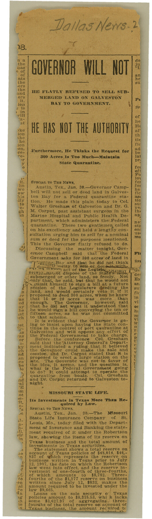
Galveston County Sketch File 38
[Newspaper clippings from January 30, 1908]
-
Map/Doc
23441
-
Collection
General Map Collection
-
Object Dates
1908/1/31 (Creation Date)
-
Counties
Galveston
-
Subjects
Surveying Sketch File
-
Height x Width
6.8 x 7.8 inches
17.3 x 19.8 cm
-
Medium
paper, print
-
Features
Galveston Bay
Federal Quarantine Station
Part of: General Map Collection
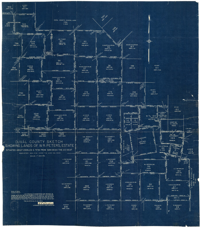
Duval County Rolled Sketch 25
Print $20.00
- Digital $50.00
Duval County Rolled Sketch 25
1944
Size 31.3 x 27.7 inches
Map/Doc 8813
Jeff Davis County Sketch File 1

Print $20.00
- Digital $50.00
Jeff Davis County Sketch File 1
Size 35.8 x 24.2 inches
Map/Doc 11855
Aransas County Sketch File 14

Print $36.00
- Digital $50.00
Aransas County Sketch File 14
1891
Size 14.0 x 8.5 inches
Map/Doc 13128
Geographical, Statistical, and Historical Map of Arkansas Territory

Print $20.00
- Digital $50.00
Geographical, Statistical, and Historical Map of Arkansas Territory
1822
Size 17.9 x 21.9 inches
Map/Doc 95713
Knox County Rolled Sketch 15

Print $40.00
- Digital $50.00
Knox County Rolled Sketch 15
1892
Size 21.9 x 54.8 inches
Map/Doc 10667
Menard County Rolled Sketch 14

Print $20.00
- Digital $50.00
Menard County Rolled Sketch 14
Size 39.8 x 34.1 inches
Map/Doc 6760
Flight Mission No. CUG-1P, Frame 79, Kleberg County

Print $20.00
- Digital $50.00
Flight Mission No. CUG-1P, Frame 79, Kleberg County
1956
Size 18.7 x 22.2 inches
Map/Doc 86144
Kimble County Sketch File 37

Print $4.00
- Digital $50.00
Kimble County Sketch File 37
1892
Size 11.2 x 8.9 inches
Map/Doc 28990

Flight Mission No. BRA-8M, Frame 132, Jefferson County

Print $20.00
- Digital $50.00
Flight Mission No. BRA-8M, Frame 132, Jefferson County
1953
Size 18.7 x 22.3 inches
Map/Doc 85628
Henderson County Sketch File 19

Print $4.00
- Digital $50.00
Henderson County Sketch File 19
Size 9.1 x 8.9 inches
Map/Doc 26363
Gaines County Sketch File 16

Print $20.00
- Digital $50.00
Gaines County Sketch File 16
1958
Size 22.0 x 17.4 inches
Map/Doc 11526
You may also like
Hidalgo County Sketch File 19

Print $42.00
- Digital $50.00
Hidalgo County Sketch File 19
1983
Size 11.3 x 8.9 inches
Map/Doc 26448
Map of McCulloch County

Print $20.00
- Digital $50.00
Map of McCulloch County
1874
Size 26.7 x 20.7 inches
Map/Doc 3857
Right of Way and Track Map, The Missouri, Kansas and Texas Ry. of Texas operated by the Missouri, Kansas and Texas Ry. of Texas, Henrietta Division

Print $40.00
- Digital $50.00
Right of Way and Track Map, The Missouri, Kansas and Texas Ry. of Texas operated by the Missouri, Kansas and Texas Ry. of Texas, Henrietta Division
1918
Size 25.1 x 56.4 inches
Map/Doc 64074
[Map of Surveys in Dallam, Texas]
![1768, [Map of Surveys in Dallam, Texas], General Map Collection](https://historictexasmaps.com/wmedia_w700/maps/1768.tif.jpg)
Print $20.00
- Digital $50.00
[Map of Surveys in Dallam, Texas]
1910
Size 19.5 x 27.8 inches
Map/Doc 1768
Andrews County Working Sketch 34

Print $20.00
- Digital $50.00
Andrews County Working Sketch 34
1990
Size 29.9 x 31.0 inches
Map/Doc 67080
Kent County Working Sketch 4

Print $20.00
- Digital $50.00
Kent County Working Sketch 4
1948
Size 27.9 x 25.8 inches
Map/Doc 70011
Polk County Sketch File 34

Print $20.00
- Digital $50.00
Polk County Sketch File 34
Size 16.9 x 18.2 inches
Map/Doc 12194

[Sections 61-63, I. & G. N. Block 1 and adjacent area to the west]
![91591, [Sections 61-63, I. & G. N. Block 1 and adjacent area to the west], Twichell Survey Records](https://historictexasmaps.com/wmedia_w700/maps/91591-1.tif.jpg)
Print $20.00
- Digital $50.00
[Sections 61-63, I. & G. N. Block 1 and adjacent area to the west]
Size 22.4 x 16.4 inches
Map/Doc 91591
Flight Mission No. DIX-6P, Frame 189, Aransas County

Print $20.00
- Digital $50.00
Flight Mission No. DIX-6P, Frame 189, Aransas County
1956
Size 19.1 x 22.8 inches
Map/Doc 83851
Matagorda County Aerial Photograph Index Sheet 4

Print $20.00
- Digital $50.00
Matagorda County Aerial Photograph Index Sheet 4
1953
Size 23.6 x 19.5 inches
Map/Doc 83725
Hall County Sketch File 30

Print $6.00
- Digital $50.00
Hall County Sketch File 30
1942
Size 11.3 x 8.9 inches
Map/Doc 24832