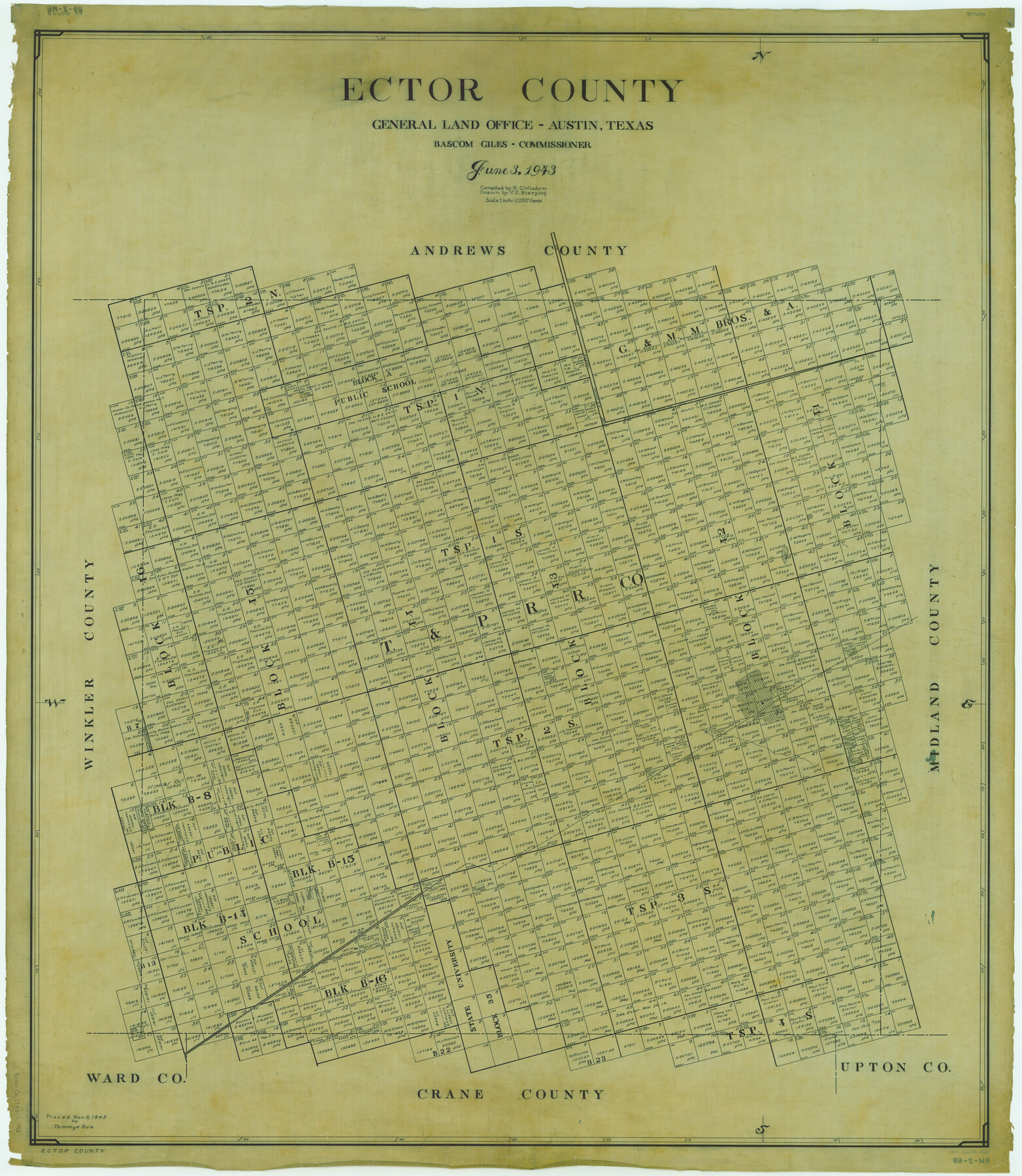
Ector County
RM-2-68
-
Map/Doc
1820
-
Collection
General Map Collection
-
Object Dates
1943/6/3 (Creation Date)
-
People and Organizations
Texas General Land Office (Publisher)
Bascom Giles (GLO Commissioner)
Victor E. Sterzing (Draftsman)
R.C. Wisdom (Compiler)
-
Counties
Ector
-
Subjects
County
-
Height x Width
45.8 x 39.8 inches
116.3 x 101.1 cm
-
Comments
Traced November 5, 1943 by Tommye Buie.
Part of: General Map Collection
Anderson County Rolled Sketch 15

Print $20.00
- Digital $50.00
Anderson County Rolled Sketch 15
2002
Size 40.0 x 28.3 inches
Map/Doc 78315
Runnels County Rolled Sketch 55

Print $20.00
- Digital $50.00
Runnels County Rolled Sketch 55
2012
Size 20.9 x 18.7 inches
Map/Doc 93386
Dimmit County Boundary File 8

Print $48.00
- Digital $50.00
Dimmit County Boundary File 8
Size 7.2 x 37.2 inches
Map/Doc 52597
Parker County Working Sketch 9

Print $20.00
- Digital $50.00
Parker County Working Sketch 9
1958
Map/Doc 71459
Flight Mission No. DAG-24K, Frame 133, Matagorda County

Print $20.00
- Digital $50.00
Flight Mission No. DAG-24K, Frame 133, Matagorda County
1953
Size 18.5 x 22.3 inches
Map/Doc 86551
Edwards County

Print $40.00
- Digital $50.00
Edwards County
1900
Size 47.7 x 59.8 inches
Map/Doc 82082

Flight Mission No. CGI-1N, Frame 168, Cameron County

Print $20.00
- Digital $50.00
Flight Mission No. CGI-1N, Frame 168, Cameron County
1955
Size 18.5 x 22.2 inches
Map/Doc 84503
Flight Mission No. CRC-3R, Frame 51, Chambers County

Print $20.00
- Digital $50.00
Flight Mission No. CRC-3R, Frame 51, Chambers County
1956
Size 18.7 x 22.4 inches
Map/Doc 84824
Williamson County Sketch File 13

Print $5.00
- Digital $50.00
Williamson County Sketch File 13
Size 9.3 x 14.3 inches
Map/Doc 40328
San Luis Pass to Matagorda Bay

Print $20.00
- Digital $50.00
San Luis Pass to Matagorda Bay
1933
Size 34.3 x 47.3 inches
Map/Doc 69960
McMullen County Sketch File 47

Print $20.00
- Digital $50.00
McMullen County Sketch File 47
1989
Size 24.6 x 21.5 inches
Map/Doc 12066
You may also like
Flight Mission No. DQO-2K, Frame 150, Galveston County

Print $20.00
- Digital $50.00
Flight Mission No. DQO-2K, Frame 150, Galveston County
1952
Size 18.8 x 22.4 inches
Map/Doc 85047
Baylor County Working Sketch 14

Print $40.00
- Digital $50.00
Baylor County Working Sketch 14
1982
Size 33.5 x 55.1 inches
Map/Doc 67299
Swisher County Sketch File 2a

Print $96.00
- Digital $50.00
Swisher County Sketch File 2a
1891
Size 14.3 x 8.7 inches
Map/Doc 37578
Karnes County Sketch File 12

Print $14.00
- Digital $50.00
Karnes County Sketch File 12
1889
Size 12.7 x 8.0 inches
Map/Doc 28604
Stephens County Sketch File 25

Print $35.00
- Digital $50.00
Stephens County Sketch File 25
1875
Size 11.0 x 15.9 inches
Map/Doc 37090
Aransas County Rolled Sketch 19

Print $20.00
- Digital $50.00
Aransas County Rolled Sketch 19
1979
Size 24.8 x 36.7 inches
Map/Doc 82559
Stremme General Land Office Drawings, side view

Print $20.00
Stremme General Land Office Drawings, side view
Size 27.0 x 21.8 inches
Map/Doc 79739
Kent County Sketch File 12

Print $20.00
- Digital $50.00
Kent County Sketch File 12
1911
Size 26.8 x 23.6 inches
Map/Doc 11916
Terrell County Working Sketch Graphic Index - sheet A

Print $20.00
- Digital $50.00
Terrell County Working Sketch Graphic Index - sheet A
1931
Size 47.9 x 39.2 inches
Map/Doc 76710
Anderson County Rolled Sketch 11

Print $20.00
- Digital $50.00
Anderson County Rolled Sketch 11
1956
Size 33.4 x 34.4 inches
Map/Doc 8366
McMullen County Sketch File 47
Print $20.00
- Digital $50.00
McMullen County Sketch File 47
1989
Size 24.6 x 21.5 inches
Map/Doc 12066
Flight Mission No. CUG-3P, Frame 18, Kleberg County

Print $20.00
- Digital $50.00
Flight Mission No. CUG-3P, Frame 18, Kleberg County
1956
Size 18.5 x 22.3 inches
Map/Doc 86228