Stephens County Sketch File 25
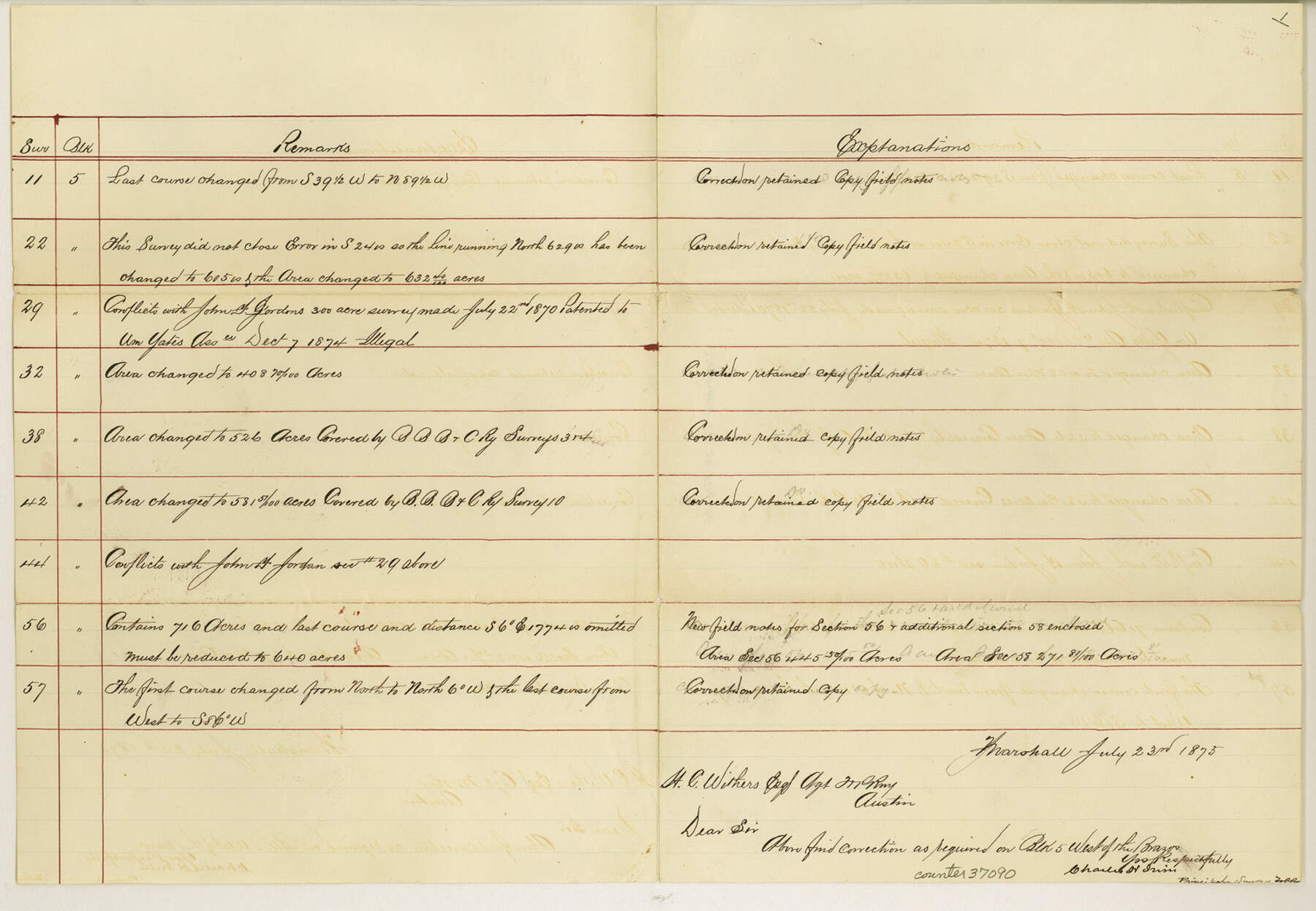
[Remarks and explanation on T. & P. RR. Co. Blocks 5, 6, 7, 8]
-
Map/Doc
37090
-
Collection
General Map Collection
-
Object Dates
7/23/1875 (Creation Date)
12/4/1984 (File Date)
-
People and Organizations
Charles H. Irvin (Surveyor/Engineer)
-
Counties
Stephens
-
Subjects
Surveying Sketch File
-
Height x Width
11.0 x 15.9 inches
27.9 x 40.4 cm
-
Medium
paper, manuscript
Part of: General Map Collection
Crockett County Rolled Sketch 88M

Print $20.00
- Digital $50.00
Crockett County Rolled Sketch 88M
1964
Size 25.2 x 34.2 inches
Map/Doc 5629
Maps of Gulf Intracoastal Waterway, Texas - Sabine River to the Rio Grande and connecting waterways including ship channels

Print $20.00
- Digital $50.00
Maps of Gulf Intracoastal Waterway, Texas - Sabine River to the Rio Grande and connecting waterways including ship channels
1966
Size 14.6 x 22.2 inches
Map/Doc 61945
Runnels County Rolled Sketch 27

Print $20.00
- Digital $50.00
Runnels County Rolled Sketch 27
1928
Size 20.0 x 39.6 inches
Map/Doc 7515
Flight Mission No. BQR-9K, Frame 16, Brazoria County

Print $20.00
- Digital $50.00
Flight Mission No. BQR-9K, Frame 16, Brazoria County
1952
Size 18.8 x 22.5 inches
Map/Doc 84045
Chambers County Sketch File 40

Print $35.00
- Digital $50.00
Chambers County Sketch File 40
1925
Size 14.0 x 8.5 inches
Map/Doc 17677
Harris County Sketch File 90

Print $46.00
- Digital $50.00
Harris County Sketch File 90
1967
Size 12.2 x 14.4 inches
Map/Doc 25596
Grimes County Working Sketch 5

Print $40.00
- Digital $50.00
Grimes County Working Sketch 5
1949
Size 43.6 x 83.2 inches
Map/Doc 63296
Taylor County Rolled Sketch 27B

Print $20.00
- Digital $50.00
Taylor County Rolled Sketch 27B
Size 19.2 x 17.7 inches
Map/Doc 7920
Controlled Mosaic by Jack Amman Photogrammetric Engineers, Inc - Sheet 42

Print $20.00
- Digital $50.00
Controlled Mosaic by Jack Amman Photogrammetric Engineers, Inc - Sheet 42
1954
Size 20.0 x 24.0 inches
Map/Doc 83501
Crockett County Sketch File 39

Print $20.00
- Digital $50.00
Crockett County Sketch File 39
1889
Size 19.7 x 32.6 inches
Map/Doc 11221
Coke County Sketch File 33

Print $20.00
- Digital $50.00
Coke County Sketch File 33
Size 22.0 x 26.6 inches
Map/Doc 11115
Wilbarger Co.

Print $40.00
- Digital $50.00
Wilbarger Co.
1907
Size 48.8 x 39.8 inches
Map/Doc 63127
You may also like
[North and West Line of Gray County, North Line of Wheeler County]
![89943, [North and West Line of Gray County, North Line of Wheeler County], Twichell Survey Records](https://historictexasmaps.com/wmedia_w700/maps/89943-1.tif.jpg)
Print $40.00
- Digital $50.00
[North and West Line of Gray County, North Line of Wheeler County]
Size 43.4 x 71.6 inches
Map/Doc 89943
Guadalupe County Sketch File 15b

Print $4.00
- Digital $50.00
Guadalupe County Sketch File 15b
1873
Size 10.3 x 8.4 inches
Map/Doc 24691
Right-of-Way and Track Map, Texas State Railroad operated by the T. and N.O. R.R. Co.

Print $40.00
- Digital $50.00
Right-of-Way and Track Map, Texas State Railroad operated by the T. and N.O. R.R. Co.
1917
Size 25.2 x 56.1 inches
Map/Doc 64171
Jim Hogg County

Print $20.00
- Digital $50.00
Jim Hogg County
1962
Size 41.3 x 30.0 inches
Map/Doc 73197
The Judicial District/County of Neches. Abolished, Spring 1842

Print $20.00
The Judicial District/County of Neches. Abolished, Spring 1842
2020
Size 15.5 x 21.7 inches
Map/Doc 96339
Map of Brazoria County, Texas

Print $20.00
- Digital $50.00
Map of Brazoria County, Texas
1879
Size 28.0 x 26.5 inches
Map/Doc 589
Crosby County Sketch File 1a

Print $6.00
- Digital $50.00
Crosby County Sketch File 1a
1874
Size 11.0 x 14.2 inches
Map/Doc 19987
Flight Mission No. BRA-7M, Frame 131, Jefferson County

Print $20.00
- Digital $50.00
Flight Mission No. BRA-7M, Frame 131, Jefferson County
1953
Size 16.2 x 16.0 inches
Map/Doc 85525
Andrews County Working Sketch 1

Print $20.00
- Digital $50.00
Andrews County Working Sketch 1
1946
Size 40.4 x 37.3 inches
Map/Doc 67047
Baylor County Working Sketch Graphic Index

Print $20.00
- Digital $50.00
Baylor County Working Sketch Graphic Index
1961
Size 41.1 x 33.6 inches
Map/Doc 76463
Shelby County Sketch File 8

Print $4.00
- Digital $50.00
Shelby County Sketch File 8
Size 10.1 x 7.9 inches
Map/Doc 36607
Baylor County Working Sketch 4

Print $20.00
- Digital $50.00
Baylor County Working Sketch 4
1938
Size 30.4 x 21.0 inches
Map/Doc 67289