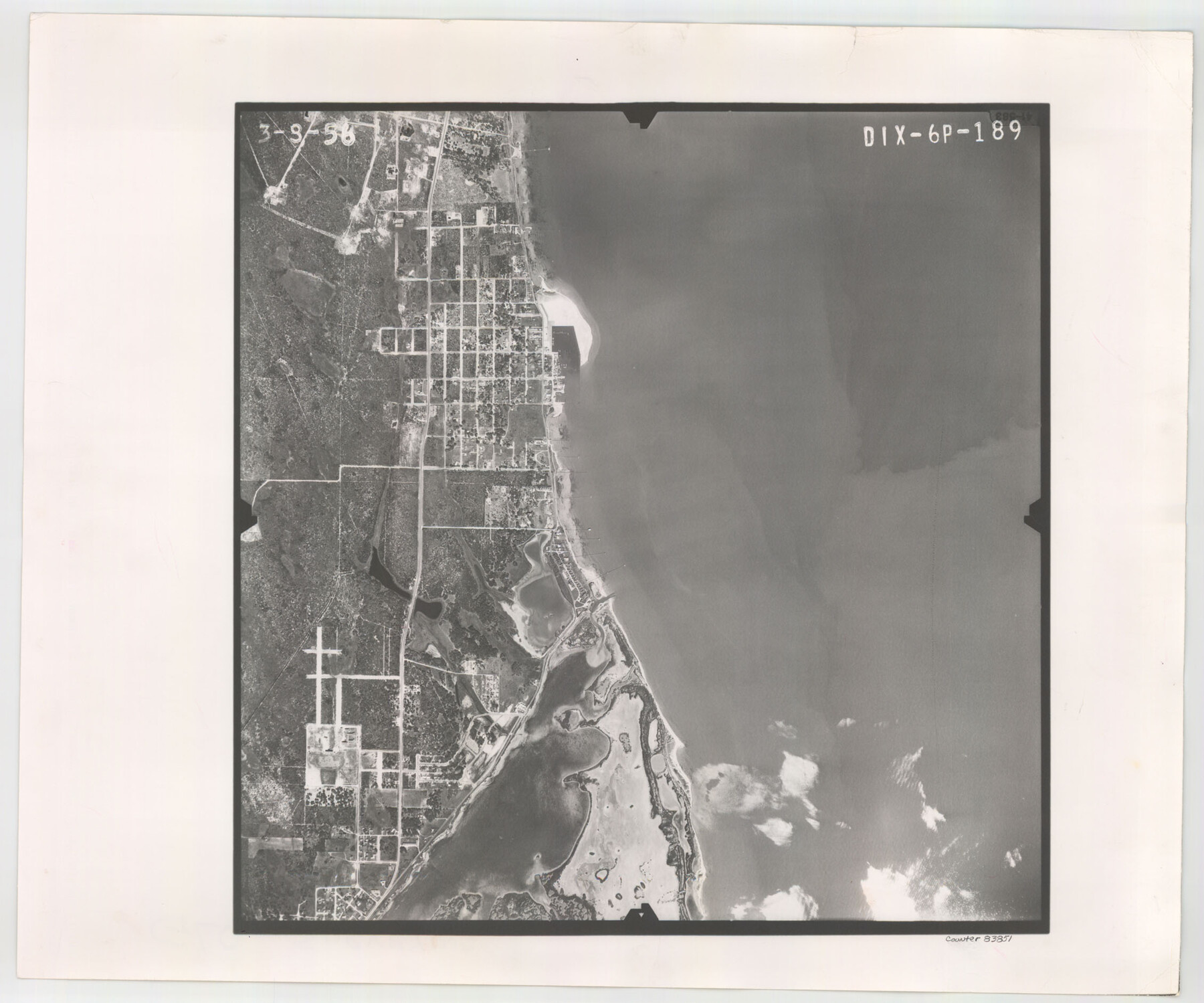
Flight Mission No. DIX-6P, Frame 189, Aransas County
DIX-6P-189
-
Map/Doc
83851
-
Collection
General Map Collection
-
Object Dates
1956/3/8 (Creation Date)
-
People and Organizations
U. S. Department of Agriculture (Publisher)
-
Counties
Aransas
-
Subjects
Aerial Photograph
-
Height x Width
19.1 x 22.8 inches
48.5 x 57.9 cm
-
Comments
Flown by V. L. Beavers and Associates of San Antonio, Texas.
Part of: General Map Collection
Flight Mission No. BRA-6M, Frame 151, Jefferson County

Print $20.00
- Digital $50.00
Flight Mission No. BRA-6M, Frame 151, Jefferson County
1953
Size 18.6 x 22.1 inches
Map/Doc 85452
Hansford County Working Sketch 1

Print $40.00
- Digital $50.00
Hansford County Working Sketch 1
1934
Size 43.0 x 54.1 inches
Map/Doc 63373
Runnels County Working Sketch 2

Print $20.00
- Digital $50.00
Runnels County Working Sketch 2
Size 19.8 x 29.4 inches
Map/Doc 63598
[East Line & Red River Railroad from Sulphur Springs to Jefferson]
![64768, [East Line & Red River Railroad from Sulphur Springs to Jefferson], General Map Collection](https://historictexasmaps.com/wmedia_w700/maps/64768.tif.jpg)
Print $40.00
- Digital $50.00
[East Line & Red River Railroad from Sulphur Springs to Jefferson]
1879
Size 38.0 x 108.5 inches
Map/Doc 64768
El Paso County Working Sketch 21

Print $20.00
- Digital $50.00
El Paso County Working Sketch 21
1960
Size 37.8 x 30.9 inches
Map/Doc 69043
Chambers County Rolled Sketch 20

Print $1171.00
- Digital $50.00
Chambers County Rolled Sketch 20
Size 10.7 x 16.2 inches
Map/Doc 43987
Zapata County Working Sketch 17

Print $20.00
- Digital $50.00
Zapata County Working Sketch 17
1970
Size 30.0 x 19.4 inches
Map/Doc 62068
Crosby County Boundary File 5

Print $60.00
- Digital $50.00
Crosby County Boundary File 5
Size 14.3 x 8.8 inches
Map/Doc 52033
Randall County Sketch File 3

Print $20.00
- Digital $50.00
Randall County Sketch File 3
1930
Size 23.8 x 16.3 inches
Map/Doc 12206
DeWitt County Sketch File 14

Print $8.00
- Digital $50.00
DeWitt County Sketch File 14
1873
Size 12.8 x 8.2 inches
Map/Doc 20827
[Beaumont, Sour Lake and Western Ry. Right of Way and Alignment - Frisco]
![64113, [Beaumont, Sour Lake and Western Ry. Right of Way and Alignment - Frisco], General Map Collection](https://historictexasmaps.com/wmedia_w700/maps/64113.tif.jpg)
Print $20.00
- Digital $50.00
[Beaumont, Sour Lake and Western Ry. Right of Way and Alignment - Frisco]
1910
Size 19.9 x 46.3 inches
Map/Doc 64113
Dallas County Boundary File 8 and 8a

Print $16.00
- Digital $50.00
Dallas County Boundary File 8 and 8a
Size 11.3 x 8.6 inches
Map/Doc 52304
You may also like
Roberts County

Print $20.00
- Digital $50.00
Roberts County
1900
Size 43.4 x 42.0 inches
Map/Doc 63002
Duval County Sketch File 17

Print $20.00
- Digital $50.00
Duval County Sketch File 17
1876
Size 19.0 x 17.8 inches
Map/Doc 11383
Hale County Rolled Sketch 10

Print $40.00
- Digital $50.00
Hale County Rolled Sketch 10
Size 52.4 x 28.3 inches
Map/Doc 76447
United States - Gulf Coast - From Latitude 26° 33' to the Rio Grande Texas

Print $20.00
- Digital $50.00
United States - Gulf Coast - From Latitude 26° 33' to the Rio Grande Texas
1916
Size 27.8 x 18.3 inches
Map/Doc 72837
Map of Stephens County

Print $20.00
- Digital $50.00
Map of Stephens County
1897
Size 43.2 x 37.6 inches
Map/Doc 16818
Rockwall County Boundary File 52a

Print $22.00
- Digital $50.00
Rockwall County Boundary File 52a
Size 12.9 x 8.3 inches
Map/Doc 58461
Eastland County Working Sketch 62

Print $20.00
- Digital $50.00
Eastland County Working Sketch 62
1989
Size 20.7 x 28.0 inches
Map/Doc 68843
Briscoe County Sketch File J

Print $40.00
- Digital $50.00
Briscoe County Sketch File J
1919
Size 19.3 x 32.0 inches
Map/Doc 11007
Hardin County Working Sketch Graphic Index

Print $20.00
- Digital $50.00
Hardin County Working Sketch Graphic Index
1940
Size 45.1 x 45.0 inches
Map/Doc 76567
Hansford County Sketch File 10

Print $6.00
- Digital $50.00
Hansford County Sketch File 10
1931
Size 8.2 x 8.5 inches
Map/Doc 24969
Stephens County Sketch File 11

Print $4.00
- Digital $50.00
Stephens County Sketch File 11
1882
Size 8.8 x 9.1 inches
Map/Doc 37055
Nautical Chart 11332 - Intracoastal Waterway - Galveston Bay to Cedar Lakes

Print $40.00
- Digital $50.00
Nautical Chart 11332 - Intracoastal Waterway - Galveston Bay to Cedar Lakes
1984
Size 22.3 x 60.3 inches
Map/Doc 69940