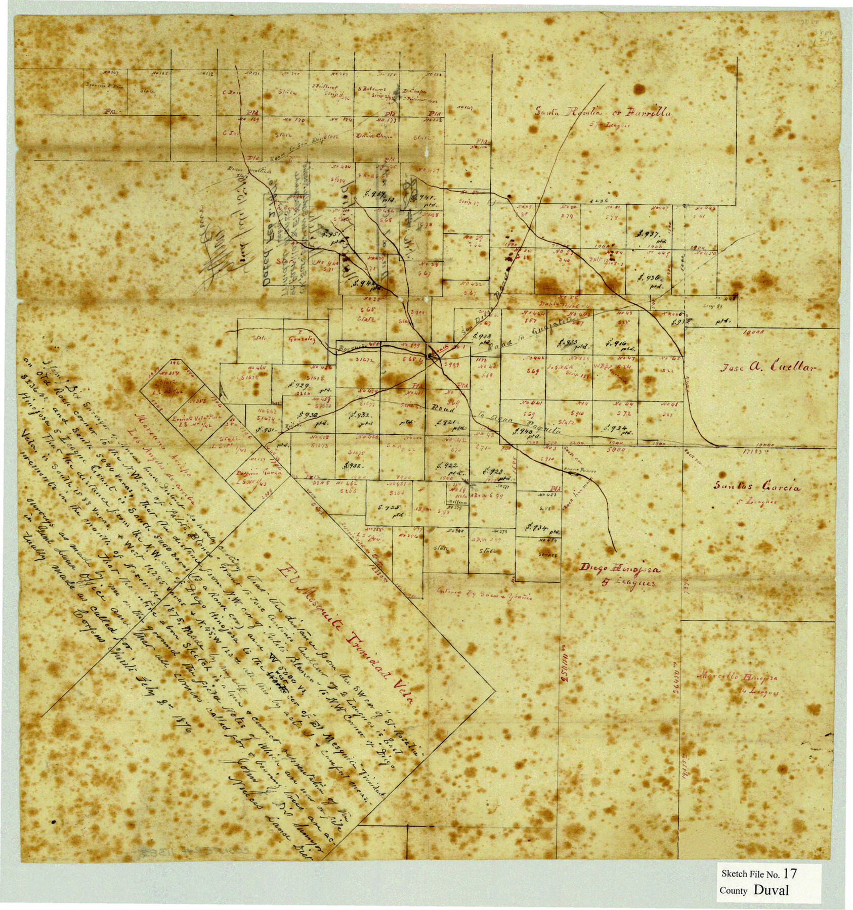
Duval County Sketch File 17
Sk. surs. between Santa Rosalin or Parilla & El Mesquite Trinidad Grants
-
Map/Doc
11383
-
Collection
General Map Collection
-
Object Dates
1876/2/2 (Creation Date)
1876/7/15 (File Date)
-
People and Organizations
John J. Dix (Surveyor/Engineer)
-
Counties
Duval
-
Subjects
Surveying Sketch File
-
Height x Width
19.0 x 17.8 inches
48.3 x 45.2 cm
-
Medium
paper, manuscript
-
Features
Road to San Diego
Road to Guajatete
Road to Agua Paquita
Charco Puerco
Part of: General Map Collection
[Sketch for Mineral Application 24072, San Jacinto River]
![65600, [Sketch for Mineral Application 24072, San Jacinto River], General Map Collection](https://historictexasmaps.com/wmedia_w700/maps/65600.tif.jpg)
Print $20.00
- Digital $50.00
[Sketch for Mineral Application 24072, San Jacinto River]
1929
Size 25.0 x 18.4 inches
Map/Doc 65600
San Patricio County Rolled Sketch 39

Print $20.00
- Digital $50.00
San Patricio County Rolled Sketch 39
1961
Size 40.4 x 31.7 inches
Map/Doc 7725
Polk County Sketch File 15

Print $8.00
- Digital $50.00
Polk County Sketch File 15
Size 12.7 x 8.4 inches
Map/Doc 34157
Reagan County Working Sketch 34

Print $40.00
- Digital $50.00
Reagan County Working Sketch 34
1965
Size 29.7 x 48.3 inches
Map/Doc 71876
Hutchinson County Sketch File 10

Print $40.00
- Digital $50.00
Hutchinson County Sketch File 10
Size 55.8 x 9.2 inches
Map/Doc 10500
Jasper County Working Sketch 26

Print $20.00
- Digital $50.00
Jasper County Working Sketch 26
1953
Size 23.1 x 18.1 inches
Map/Doc 66488
Potter County Rolled Sketch 11

Print $20.00
- Digital $50.00
Potter County Rolled Sketch 11
1986
Size 21.6 x 27.4 inches
Map/Doc 7324
Hudspeth County Sketch File 44

Print $6.00
- Digital $50.00
Hudspeth County Sketch File 44
1886
Size 11.0 x 8.5 inches
Map/Doc 27027
Hays County Rolled Sketch 24

Print $20.00
- Digital $50.00
Hays County Rolled Sketch 24
1924
Size 18.4 x 20.9 inches
Map/Doc 6180
Kimble County Working Sketch 60

Print $20.00
- Digital $50.00
Kimble County Working Sketch 60
1964
Size 43.8 x 38.2 inches
Map/Doc 70128
Map of South America engraved to illustrate Mitchell's new intermediate geography

Print $20.00
- Digital $50.00
Map of South America engraved to illustrate Mitchell's new intermediate geography
1885
Size 12.2 x 9.0 inches
Map/Doc 93525
Atascosa County Sketch File 15a

Print $5.00
- Digital $50.00
Atascosa County Sketch File 15a
1879
Size 17.4 x 8.2 inches
Map/Doc 13777
You may also like
Hopkins County Sketch File 13

Print $4.00
- Digital $50.00
Hopkins County Sketch File 13
1858
Size 12.7 x 8.2 inches
Map/Doc 26709
Coryell County Working Sketch 25

Print $20.00
- Digital $50.00
Coryell County Working Sketch 25
1986
Size 22.2 x 29.4 inches
Map/Doc 68232
[Blocks 33-35, Township 5N]
![92029, [Blocks 33-35, Township 5N], Twichell Survey Records](https://historictexasmaps.com/wmedia_w700/maps/92029-1.tif.jpg)
Print $20.00
- Digital $50.00
[Blocks 33-35, Township 5N]
Size 37.4 x 23.8 inches
Map/Doc 92029
Texas Panhandle East Boundary Line

Print $20.00
- Digital $50.00
Texas Panhandle East Boundary Line
1898
Size 11.6 x 35.5 inches
Map/Doc 1741
[Stone, Kyle and Kyle Block M6]
![90395, [Stone, Kyle and Kyle Block M6], Twichell Survey Records](https://historictexasmaps.com/wmedia_w700/maps/90395-1.tif.jpg)
Print $20.00
- Digital $50.00
[Stone, Kyle and Kyle Block M6]
Size 26.8 x 21.6 inches
Map/Doc 90395
Map of Lavaca County, Texas

Print $20.00
- Digital $50.00
Map of Lavaca County, Texas
1879
Size 22.8 x 25.0 inches
Map/Doc 561
Plan of the City of Galveston, Texas

Print $20.00
- Digital $50.00
Plan of the City of Galveston, Texas
1845
Size 18.4 x 27.8 inches
Map/Doc 62970

Lamb County Working Sketch 4

Print $40.00
- Digital $50.00
Lamb County Working Sketch 4
1984
Size 42.9 x 58.0 inches
Map/Doc 70277
Starr County Working Sketch 17

Print $20.00
- Digital $50.00
Starr County Working Sketch 17
1982
Size 46.1 x 42.7 inches
Map/Doc 63933
Burleson County Working Sketch 35

Print $3.00
- Digital $50.00
Burleson County Working Sketch 35
1981
Size 16.4 x 8.7 inches
Map/Doc 67754
Nelson & White's Official Map of Beaumont

Print $40.00
Nelson & White's Official Map of Beaumont
1902
Size 54.3 x 39.4 inches
Map/Doc 93558