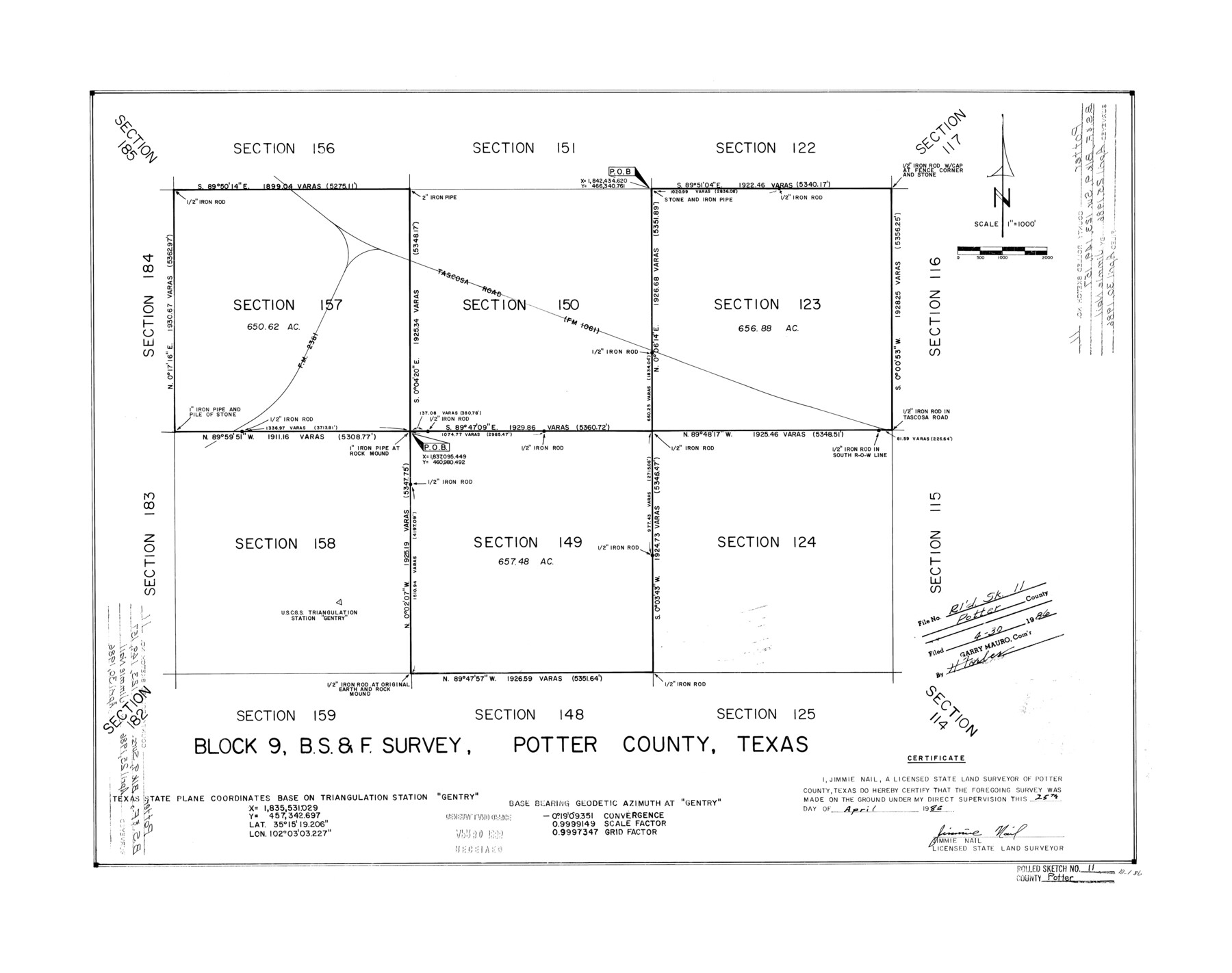
Potter County Rolled Sketch 11
Block 9, B. S. & F. survey, Potter County, Texas
-
Map/Doc
7324
-
Collection
General Map Collection
-
Object Dates
1986/4/25 (Creation Date)
1986/4/30 (File Date)
-
People and Organizations
Jimmie Nail (Surveyor/Engineer)
-
Counties
Potter
-
Subjects
Surveying Rolled Sketch
-
Height x Width
21.6 x 27.4 inches
54.9 x 69.6 cm
-
Medium
mylar, print
-
Scale
1" = 1000 feet
Part of: General Map Collection
Map of Zapata County

Print $20.00
- Digital $50.00
Map of Zapata County
1879
Size 27.4 x 25.6 inches
Map/Doc 4176
Hill County Sketch File 9

Print $4.00
- Digital $50.00
Hill County Sketch File 9
1857
Size 8.3 x 10.3 inches
Map/Doc 26476
Brooks County Sketch File 3

Print $40.00
- Digital $50.00
Brooks County Sketch File 3
Size 21.5 x 19.0 inches
Map/Doc 11016
Flight Mission No. CRC-3R, Frame 199, Chambers County

Print $20.00
- Digital $50.00
Flight Mission No. CRC-3R, Frame 199, Chambers County
1956
Size 18.5 x 22.3 inches
Map/Doc 84854
Lubbock County

Print $20.00
- Digital $50.00
Lubbock County
1879
Size 23.8 x 21.7 inches
Map/Doc 3829
Mills County Boundary File 1

Print $28.00
- Digital $50.00
Mills County Boundary File 1
Size 8.3 x 8.0 inches
Map/Doc 57259

Tarrant County Boundary File 3

Print $30.00
- Digital $50.00
Tarrant County Boundary File 3
Size 11.4 x 8.8 inches
Map/Doc 59136
Township 6 South Range 13 West, South Western District, Louisiana

Print $20.00
- Digital $50.00
Township 6 South Range 13 West, South Western District, Louisiana
1879
Size 19.6 x 24.8 inches
Map/Doc 65886
Throckmorton County Working Sketch 1

Print $20.00
- Digital $50.00
Throckmorton County Working Sketch 1
1913
Size 12.8 x 14.4 inches
Map/Doc 62110
Flight Mission No. DQO-12K, Frame 34, Galveston County

Print $20.00
- Digital $50.00
Flight Mission No. DQO-12K, Frame 34, Galveston County
1952
Size 18.8 x 22.5 inches
Map/Doc 85225
Burnet County Working Sketch 26

Print $20.00
- Digital $50.00
Burnet County Working Sketch 26
2016
Size 18.7 x 24.8 inches
Map/Doc 93979
You may also like
Fractional Township No. 7 South Range No. 7 East of the Indian Meridian, Indian Territory

Print $20.00
- Digital $50.00
Fractional Township No. 7 South Range No. 7 East of the Indian Meridian, Indian Territory
1898
Size 19.2 x 24.3 inches
Map/Doc 75212

Travis County Appraisal District Plat Map 3_0104

Print $20.00
- Digital $50.00
Travis County Appraisal District Plat Map 3_0104
Size 21.5 x 26.4 inches
Map/Doc 94224
Liberty County Sketch File 21

Print $5.00
- Digital $50.00
Liberty County Sketch File 21
1858
Size 7.9 x 13.0 inches
Map/Doc 29928
Val Verde County Working Sketch 40

Print $20.00
- Digital $50.00
Val Verde County Working Sketch 40
1943
Size 31.5 x 29.8 inches
Map/Doc 72175
Cherokee County Working Sketch 2

Print $20.00
- Digital $50.00
Cherokee County Working Sketch 2
1932
Size 40.8 x 35.9 inches
Map/Doc 67957
Stonewall County Rolled Sketch 30

Print $20.00
- Digital $50.00
Stonewall County Rolled Sketch 30
Size 25.5 x 37.3 inches
Map/Doc 7874
Jefferson County Aerial Photograph Index Sheet 1

Print $20.00
- Digital $50.00
Jefferson County Aerial Photograph Index Sheet 1
1953
Size 23.3 x 16.8 inches
Map/Doc 83707
Glasscock County Working Sketch 16

Print $40.00
- Digital $50.00
Glasscock County Working Sketch 16
1984
Size 61.2 x 44.0 inches
Map/Doc 63189
Jasper County Sketch File 24

Print $4.00
- Digital $50.00
Jasper County Sketch File 24
1925
Size 10.9 x 8.3 inches
Map/Doc 27824
Guadalupe County Working Sketch 6

Print $20.00
- Digital $50.00
Guadalupe County Working Sketch 6
1948
Size 24.0 x 19.7 inches
Map/Doc 63315
Runnels County Working Sketch 3

Print $20.00
- Digital $50.00
Runnels County Working Sketch 3
1888
Size 22.1 x 20.3 inches
Map/Doc 63599