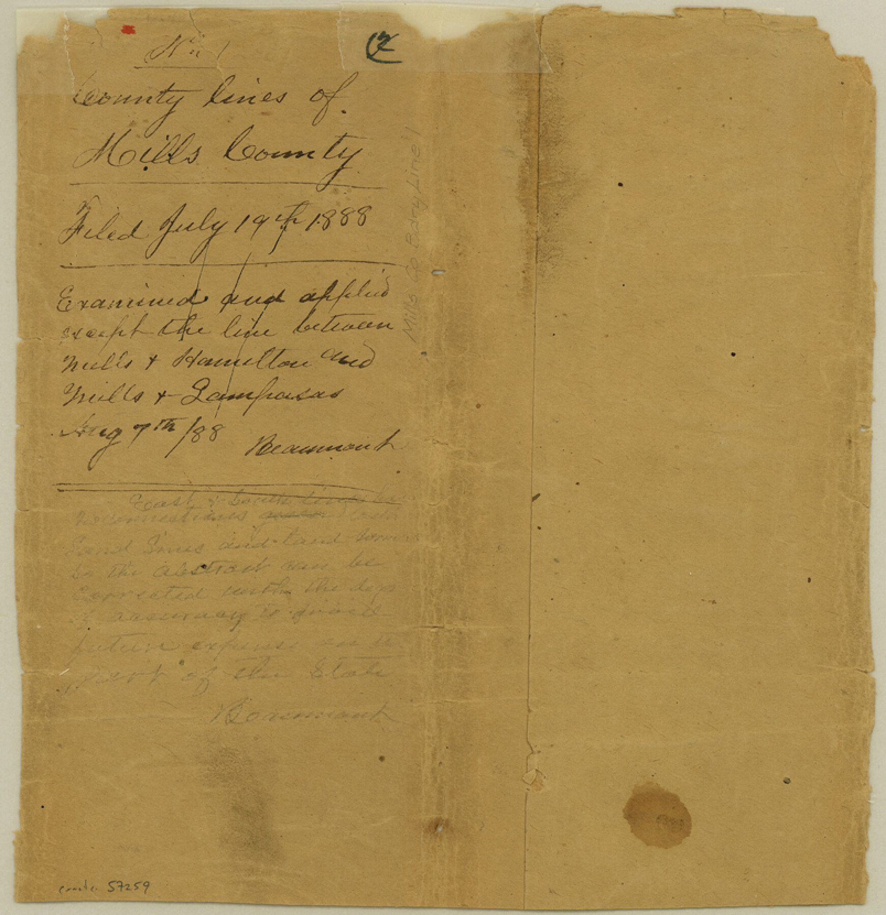
Mills County Boundary File 1
Co. Lines of Mills Co.
-
Map/Doc
57259
-
Collection
General Map Collection
-
Counties
Mills
-
Subjects
County Boundaries
-
Height x Width
8.3 x 8.0 inches
21.1 x 20.3 cm
Part of: General Map Collection
Location of the Kansas City Shreveport & Gulf Railroad, Beaumont to Mayersburg

Print $20.00
- Digital $50.00
Location of the Kansas City Shreveport & Gulf Railroad, Beaumont to Mayersburg
1896
Size 26.0 x 36.5 inches
Map/Doc 64771
Medina County Rolled Sketch 2

Print $20.00
- Digital $50.00
Medina County Rolled Sketch 2
1936
Size 31.3 x 28.6 inches
Map/Doc 6739
Menard County Working Sketch 25

Print $20.00
- Digital $50.00
Menard County Working Sketch 25
1952
Size 32.2 x 42.8 inches
Map/Doc 70972
Flight Mission No. CLL-3N, Frame 41, Willacy County

Print $20.00
- Digital $50.00
Flight Mission No. CLL-3N, Frame 41, Willacy County
1954
Size 18.4 x 22.1 inches
Map/Doc 87099
Fort Bend County Working Sketch 2

Print $20.00
- Digital $50.00
Fort Bend County Working Sketch 2
1897
Size 18.3 x 28.4 inches
Map/Doc 69208
Flight Mission No. CUG-1P, Frame 22, Kleberg County

Print $20.00
- Digital $50.00
Flight Mission No. CUG-1P, Frame 22, Kleberg County
1956
Size 18.7 x 22.1 inches
Map/Doc 86112
Trinity County Rolled Sketch 4

Print $20.00
- Digital $50.00
Trinity County Rolled Sketch 4
1948
Size 38.5 x 42.4 inches
Map/Doc 10026
Coleman County Working Sketch 11

Print $20.00
- Digital $50.00
Coleman County Working Sketch 11
1950
Size 24.2 x 18.2 inches
Map/Doc 68077

Wood County Working Sketch Graphic Index

Print $20.00
- Digital $50.00
Wood County Working Sketch Graphic Index
1942
Size 40.6 x 36.4 inches
Map/Doc 76746
Freestone County Sketch File 17

Print $4.00
- Digital $50.00
Freestone County Sketch File 17
1859
Size 6.3 x 8.1 inches
Map/Doc 23074
Travis County Working Sketch 2

Print $20.00
- Digital $50.00
Travis County Working Sketch 2
1906
Size 30.8 x 25.9 inches
Map/Doc 69386
You may also like
Culberson County Working Sketch 4

Print $20.00
- Digital $50.00
Culberson County Working Sketch 4
Size 37.7 x 32.2 inches
Map/Doc 68456
[Block N and part of Block B]
![90363, [Block N and part of Block B], Twichell Survey Records](https://historictexasmaps.com/wmedia_w700/maps/90363-1.tif.jpg)
Print $3.00
- Digital $50.00
[Block N and part of Block B]
Size 9.6 x 12.8 inches
Map/Doc 90363
Uvalde County Sketch File 18

Print $6.00
- Digital $50.00
Uvalde County Sketch File 18
1883
Size 10.9 x 8.2 inches
Map/Doc 38997
Nueces County Working Sketch 6

Print $20.00
- Digital $50.00
Nueces County Working Sketch 6
1987
Size 33.7 x 42.9 inches
Map/Doc 71308
[Maps of surveys in Reeves & Culberson Cos]
![61133, [Maps of surveys in Reeves & Culberson Cos], General Map Collection](https://historictexasmaps.com/wmedia_w700/maps/61133.tif.jpg)
Print $20.00
- Digital $50.00
[Maps of surveys in Reeves & Culberson Cos]
1937
Size 30.7 x 24.8 inches
Map/Doc 61133
Burnet County Working Sketch 20

Print $40.00
- Digital $50.00
Burnet County Working Sketch 20
1983
Size 48.1 x 41.2 inches
Map/Doc 67863
Fannin County Rolled Sketch 18C

Print $20.00
- Digital $50.00
Fannin County Rolled Sketch 18C
Size 16.0 x 12.9 inches
Map/Doc 5870
Limestone County Sketch File 10b

Print $22.00
- Digital $50.00
Limestone County Sketch File 10b
1875
Size 15.0 x 14.1 inches
Map/Doc 30175
Rockwall County Boundary File 2

Print $12.00
- Digital $50.00
Rockwall County Boundary File 2
Size 14.4 x 8.9 inches
Map/Doc 58385
The Judicial District/County of Spring Creek. Abolished, Spring 1842

Print $20.00
The Judicial District/County of Spring Creek. Abolished, Spring 1842
2020
Size 15.7 x 21.7 inches
Map/Doc 96349
Flight Mission No. CRC-2R, Frame 184, Chambers County

Print $20.00
- Digital $50.00
Flight Mission No. CRC-2R, Frame 184, Chambers County
1956
Size 18.6 x 22.2 inches
Map/Doc 84762
Kimble County

Print $40.00
- Digital $50.00
Kimble County
1890
Size 38.8 x 58.1 inches
Map/Doc 78414