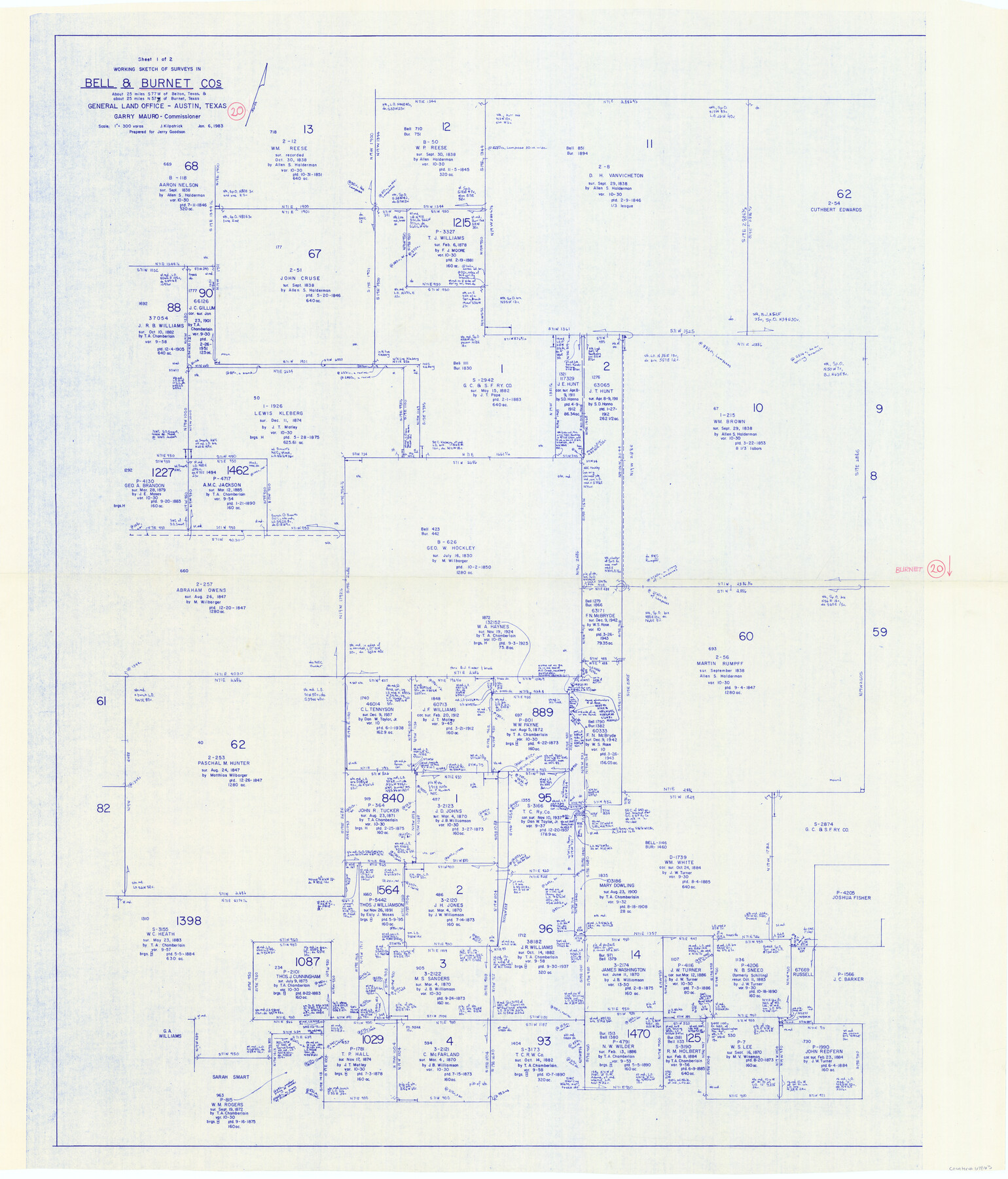
Burnet County Working Sketch 20
-
Map/Doc
67863
-
Collection
General Map Collection
-
Object Dates
1/6/1983 (Creation Date)
-
People and Organizations
Joan Kilpatrick (Draftsman)
-
Counties
Burnet Bell
-
Subjects
Surveying Working Sketch
-
Height x Width
48.1 x 41.2 inches
122.2 x 104.7 cm
-
Scale
1" = 300 varas
Part of: General Map Collection
Jefferson County Rolled Sketch 48

Print $20.00
- Digital $50.00
Jefferson County Rolled Sketch 48
Size 15.3 x 24.9 inches
Map/Doc 6405
Map of Denton County

Print $20.00
- Digital $50.00
Map of Denton County
1897
Size 42.7 x 39.5 inches
Map/Doc 4932
Flight Mission No. DQN-1K, Frame 117, Calhoun County

Print $20.00
- Digital $50.00
Flight Mission No. DQN-1K, Frame 117, Calhoun County
1953
Size 18.5 x 22.2 inches
Map/Doc 84183
Baylor County Rolled Sketch BHK

Print $20.00
- Digital $50.00
Baylor County Rolled Sketch BHK
1892
Size 18.8 x 43.5 inches
Map/Doc 5130

Kendall County Boundary File 2

Print $4.00
- Digital $50.00
Kendall County Boundary File 2
Size 10.2 x 8.2 inches
Map/Doc 55746
Calhoun County Rolled Sketch 14

Print $20.00
- Digital $50.00
Calhoun County Rolled Sketch 14
1949
Size 20.2 x 29.6 inches
Map/Doc 5510
Hamilton County Map

Print $40.00
- Digital $50.00
Hamilton County Map
1887
Size 38.2 x 54.4 inches
Map/Doc 16844
Rockwall County Boundary File 4a

Print $10.00
- Digital $50.00
Rockwall County Boundary File 4a
Size 11.2 x 8.8 inches
Map/Doc 58399
Robertson County Sketch File 11

Print $12.00
Robertson County Sketch File 11
Size 9.4 x 7.9 inches
Map/Doc 35398
Chart of the Harbour of San [Luis]
![72761, Chart of the Harbour of San [Luis], General Map Collection](https://historictexasmaps.com/wmedia_w700/maps/72761.tif.jpg)
Print $20.00
- Digital $50.00
Chart of the Harbour of San [Luis]
1846
Size 27.3 x 18.3 inches
Map/Doc 72761
Flight Mission No. BRE-4P, Frame 172, Nueces County

Print $20.00
- Digital $50.00
Flight Mission No. BRE-4P, Frame 172, Nueces County
1956
Size 18.4 x 22.1 inches
Map/Doc 86835
You may also like
San Jacinto County Working Sketch 27

Print $20.00
- Digital $50.00
San Jacinto County Working Sketch 27
1944
Size 30.5 x 23.3 inches
Map/Doc 63740
Nolan County Sketch File 2

Print $40.00
- Digital $50.00
Nolan County Sketch File 2
Size 49.5 x 41.6 inches
Map/Doc 10556
Andrews County Working Sketch 7

Print $20.00
- Digital $50.00
Andrews County Working Sketch 7
1954
Size 16.0 x 24.2 inches
Map/Doc 67053
Duval County Sketch File 59

Print $6.00
- Digital $50.00
Duval County Sketch File 59
1940
Size 14.4 x 9.0 inches
Map/Doc 21425
Crosby County Sketch File 15

Print $20.00
- Digital $50.00
Crosby County Sketch File 15
1903
Size 28.7 x 20.4 inches
Map/Doc 11250
[R. T. Bucy's Survey 3, League 321]
![91295, [R. T. Bucy's Survey 3, League 321], Twichell Survey Records](https://historictexasmaps.com/wmedia_w700/maps/91295-1.tif.jpg)
Print $20.00
- Digital $50.00
[R. T. Bucy's Survey 3, League 321]
Size 12.2 x 18.7 inches
Map/Doc 91295
Map of Panola County

Print $20.00
- Digital $50.00
Map of Panola County
1863
Size 19.6 x 19.3 inches
Map/Doc 4503
The Republic County of Fayette. January 29, 1842

Print $20.00
The Republic County of Fayette. January 29, 1842
2020
Size 14.7 x 21.7 inches
Map/Doc 96134
Colorado County Sketch File 32

Print $4.00
- Digital $50.00
Colorado County Sketch File 32
1847
Size 13.0 x 8.4 inches
Map/Doc 18986
Edwards County Working Sketch 58

Print $20.00
- Digital $50.00
Edwards County Working Sketch 58
1953
Size 22.4 x 29.8 inches
Map/Doc 68934
Jefferson County Rolled Sketch 44

Print $20.00
- Digital $50.00
Jefferson County Rolled Sketch 44
1957
Size 26.9 x 25.5 inches
Map/Doc 6401
Fisher County Rolled Sketch 5

Print $20.00
- Digital $50.00
Fisher County Rolled Sketch 5
1961
Size 39.1 x 33.7 inches
Map/Doc 8890