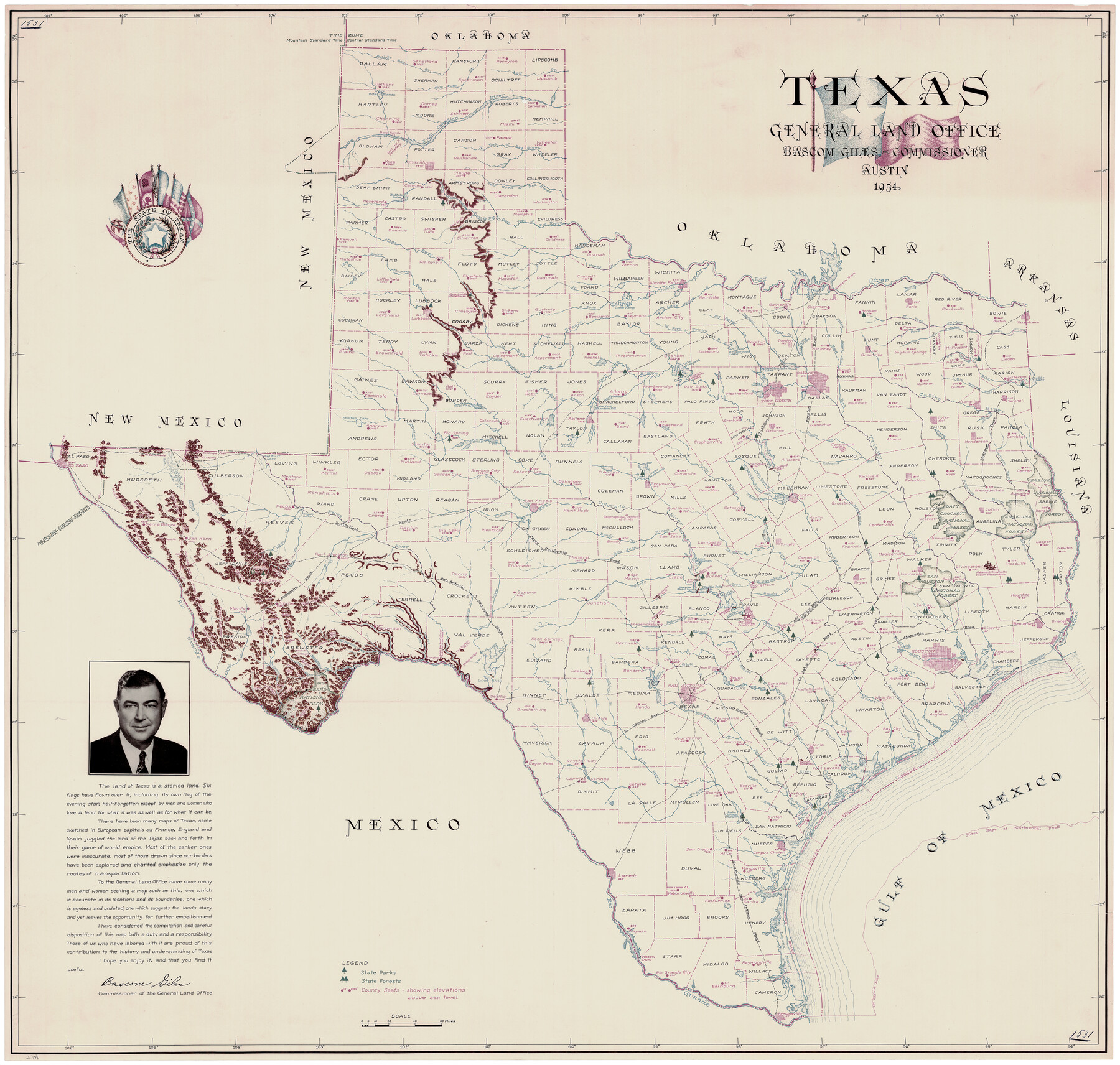
Texas
-
Map/Doc
366
-
Collection
General Map Collection
-
Object Dates
1954 (Creation Date)
-
People and Organizations
General Land Office (Publisher)
Bascom Giles (GLO Commissioner)
[Eltea Armstrong] (Draftsman)
-
Subjects
State of Texas
-
Height x Width
33.5 x 36.2 inches
85.1 x 92.0 cm
-
Medium
paper, print
Part of: General Map Collection
Flight Mission No. BRE-1P, Frame 100, Nueces County

Print $20.00
- Digital $50.00
Flight Mission No. BRE-1P, Frame 100, Nueces County
1956
Size 18.4 x 22.1 inches
Map/Doc 86671
Fannin County Boundary File 10a and 10b and 10c

Print $2.00
- Digital $50.00
Fannin County Boundary File 10a and 10b and 10c
Size 11.2 x 9.1 inches
Map/Doc 53327
Jeff Davis County Working Sketch 29

Print $20.00
- Digital $50.00
Jeff Davis County Working Sketch 29
1967
Size 25.8 x 41.6 inches
Map/Doc 66524
Erforschung von Nordwest-Texas

Print $20.00
- Digital $50.00
Erforschung von Nordwest-Texas
1873
Size 11.4 x 9.4 inches
Map/Doc 95144
[Cotton Belt, St. Louis Southwestern Railway of Texas, Alignment through Smith County]
![64375, [Cotton Belt, St. Louis Southwestern Railway of Texas, Alignment through Smith County], General Map Collection](https://historictexasmaps.com/wmedia_w700/maps/64375.tif.jpg)
Print $20.00
- Digital $50.00
[Cotton Belt, St. Louis Southwestern Railway of Texas, Alignment through Smith County]
1903
Size 21.3 x 28.5 inches
Map/Doc 64375
Amistad International Reservoir on Rio Grande 65

Print $20.00
- Digital $50.00
Amistad International Reservoir on Rio Grande 65
1949
Size 28.2 x 39.8 inches
Map/Doc 73350
Hutchinson County Rolled Sketch 36A

Print $20.00
- Digital $50.00
Hutchinson County Rolled Sketch 36A
1888
Size 21.3 x 25.0 inches
Map/Doc 6294
Map of Asylum & University lands situated on the waters of Hubbards Creek

Print $20.00
- Digital $50.00
Map of Asylum & University lands situated on the waters of Hubbards Creek
1857
Size 21.2 x 28.5 inches
Map/Doc 2491
Flight Mission No. DQN-7K, Frame 38, Calhoun County

Print $20.00
- Digital $50.00
Flight Mission No. DQN-7K, Frame 38, Calhoun County
1953
Size 18.5 x 22.2 inches
Map/Doc 84476
Flight Mission No. DQN-1K, Frame 132, Calhoun County

Print $20.00
- Digital $50.00
Flight Mission No. DQN-1K, Frame 132, Calhoun County
1953
Size 18.4 x 22.1 inches
Map/Doc 84195
Map of Gregg County

Print $20.00
- Digital $50.00
Map of Gregg County
1874
Size 14.0 x 13.9 inches
Map/Doc 3604
Aransas County Sketch File 29

Print $24.00
- Digital $50.00
Aransas County Sketch File 29
Size 7.8 x 8.1 inches
Map/Doc 13234
You may also like
Parmer County

Print $20.00
- Digital $50.00
Parmer County
1926
Size 43.9 x 35.4 inches
Map/Doc 73259
[Galveston, Harrisburg & San Antonio through El Paso County]
![64007, [Galveston, Harrisburg & San Antonio through El Paso County], General Map Collection](https://historictexasmaps.com/wmedia_w700/maps/64007.tif.jpg)
Print $20.00
- Digital $50.00
[Galveston, Harrisburg & San Antonio through El Paso County]
1906
Size 13.4 x 33.9 inches
Map/Doc 64007
Stephens County Boundary File 81

Print $44.00
- Digital $50.00
Stephens County Boundary File 81
Size 9.2 x 3.8 inches
Map/Doc 58906
Edwards County Sketch File 14 1/2

Print $20.00
- Digital $50.00
Edwards County Sketch File 14 1/2
1887
Size 18.3 x 15.3 inches
Map/Doc 11426

Flight Mission No. CRE-1R, Frame 64, Jackson County

Print $20.00
- Digital $50.00
Flight Mission No. CRE-1R, Frame 64, Jackson County
1956
Size 15.9 x 15.9 inches
Map/Doc 85327
Rio Grande Rectification Project, El Paso and Juarez Valley

Print $20.00
- Digital $50.00
Rio Grande Rectification Project, El Paso and Juarez Valley
1935
Size 10.7 x 29.4 inches
Map/Doc 60867
Goliad County Working Sketch 9

Print $20.00
- Digital $50.00
Goliad County Working Sketch 9
1938
Size 19.3 x 27.6 inches
Map/Doc 63199
Armstrong County Working Sketch 11

Print $20.00
- Digital $50.00
Armstrong County Working Sketch 11
2025
Size 24.7 x 36.5 inches
Map/Doc 97507
Flight Mission No. BRA-6M, Frame 80, Jefferson County

Print $20.00
- Digital $50.00
Flight Mission No. BRA-6M, Frame 80, Jefferson County
1953
Size 18.6 x 22.3 inches
Map/Doc 85424
Loving County Rolled Sketch 1A

Print $40.00
- Digital $50.00
Loving County Rolled Sketch 1A
Size 77.9 x 42.9 inches
Map/Doc 9461
Travis County Sketch File 2

Print $4.00
- Digital $50.00
Travis County Sketch File 2
1851
Size 8.2 x 9.9 inches
Map/Doc 38271