Aransas County Sketch File 29
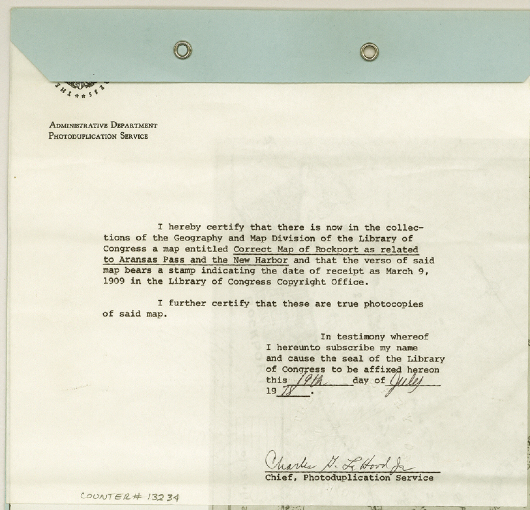
Correct map of Rockport as related to Aransas Pass and the new harbor
-
Map/Doc
13234
-
Collection
General Map Collection
-
Object Dates
1978/7/19 (Copy/Tracing Date)
1979/9/4 (File Date)
-
People and Organizations
John B. Eddins (Compiler)
-
Counties
Aransas
-
Subjects
Surveying Sketch File
-
Height x Width
7.8 x 8.1 inches
19.8 x 20.6 cm
-
Medium
multi-page, multi-format
-
Features
Gulf of Mexico
Aransas Bay
Rockport
Live Oak Peninsula
St. Joseph's Island
Mud Island
Shallow Bay
Redfish Bay
Aransas Pass
Harbor Island
Mud Flats
Light House
Rockport & Port Aransas Railway
Shoal Bay
Quarantine
Part of: General Map Collection
Flight Mission No. DAG-24K, Frame 124, Matagorda County

Print $20.00
- Digital $50.00
Flight Mission No. DAG-24K, Frame 124, Matagorda County
1953
Size 18.4 x 22.3 inches
Map/Doc 86542

Southern Pacific Lines in Texas and Louisiana (G. H. & S. A. Ry.) Circuit Plan of Automatic Block Signals, Automatic Train Control and Flatonia Interlocking Plant No. 3

Print $40.00
- Digital $50.00
Southern Pacific Lines in Texas and Louisiana (G. H. & S. A. Ry.) Circuit Plan of Automatic Block Signals, Automatic Train Control and Flatonia Interlocking Plant No. 3
1927
Size 43.5 x 215.5 inches
Map/Doc 90044
Victoria County Working Sketch 4

Print $20.00
- Digital $50.00
Victoria County Working Sketch 4
1944
Size 37.0 x 47.6 inches
Map/Doc 72274
Henderson County Working Sketch 17

Print $20.00
- Digital $50.00
Henderson County Working Sketch 17
1937
Size 27.3 x 27.4 inches
Map/Doc 66150
Fort Bend County Rolled Sketch 4

Print $20.00
- Digital $50.00
Fort Bend County Rolled Sketch 4
1956
Size 30.1 x 43.8 inches
Map/Doc 5894
Caddo Lake and Subdivision

Print $20.00
- Digital $50.00
Caddo Lake and Subdivision
1918
Size 35.0 x 29.8 inches
Map/Doc 93283
Flight Mission No. BRE-5P, Frame 199, Nueces County

Print $20.00
- Digital $50.00
Flight Mission No. BRE-5P, Frame 199, Nueces County
1956
Size 18.4 x 22.3 inches
Map/Doc 86839
Mud Creek in Nacogdoches District

Print $2.00
- Digital $50.00
Mud Creek in Nacogdoches District
1846
Size 10.7 x 7.8 inches
Map/Doc 345
Jefferson County Sketch File 44

Print $20.00
- Digital $50.00
Jefferson County Sketch File 44
1917
Size 22.8 x 32.9 inches
Map/Doc 11878
Willacy County

Print $20.00
- Digital $50.00
Willacy County
1921
Size 23.5 x 31.0 inches
Map/Doc 77459
Aransas County Sketch File 10

Print $4.00
- Digital $50.00
Aransas County Sketch File 10
1871
Size 7.3 x 9.4 inches
Map/Doc 13116
You may also like
Map of Tyler County

Print $20.00
- Digital $50.00
Map of Tyler County
1897
Size 42.2 x 39.2 inches
Map/Doc 63081
Map of Calhoun County, Texas

Print $20.00
- Digital $50.00
Map of Calhoun County, Texas
1879
Size 22.8 x 18.7 inches
Map/Doc 670
Upton County Rolled Sketch 34

Print $20.00
- Digital $50.00
Upton County Rolled Sketch 34
1951
Size 34.4 x 34.3 inches
Map/Doc 10050
Palo Pinto County Sketch File 25

Print $26.00
- Digital $50.00
Palo Pinto County Sketch File 25
1874
Size 10.1 x 8.9 inches
Map/Doc 33404
Flight Mission No. DQN-1K, Frame 41, Calhoun County

Print $20.00
- Digital $50.00
Flight Mission No. DQN-1K, Frame 41, Calhoun County
1953
Size 18.5 x 22.2 inches
Map/Doc 84141
Pecos County Rolled Sketch Q

Print $20.00
- Digital $50.00
Pecos County Rolled Sketch Q
Size 18.7 x 12.2 inches
Map/Doc 7311
Medina County Sketch File 5

Print $8.00
- Digital $50.00
Medina County Sketch File 5
Size 8.2 x 3.8 inches
Map/Doc 31450
Anderson County Working Sketch 44

Print $20.00
- Digital $50.00
Anderson County Working Sketch 44
1991
Size 27.7 x 32.3 inches
Map/Doc 67044
Flight Mission No. DQN-1K, Frame 129, Calhoun County

Print $20.00
- Digital $50.00
Flight Mission No. DQN-1K, Frame 129, Calhoun County
1953
Size 18.5 x 22.2 inches
Map/Doc 84192
Brazos County Sketch File 5

Print $34.00
- Digital $50.00
Brazos County Sketch File 5
1935
Size 8.2 x 7.1 inches
Map/Doc 15559
Flight Mission No. CRC-5R, Frame 32, Chambers County

Print $20.00
- Digital $50.00
Flight Mission No. CRC-5R, Frame 32, Chambers County
1956
Size 18.5 x 22.4 inches
Map/Doc 84951
Wilson County Working Sketch 13

Print $40.00
- Digital $50.00
Wilson County Working Sketch 13
1985
Size 23.9 x 53.5 inches
Map/Doc 72593