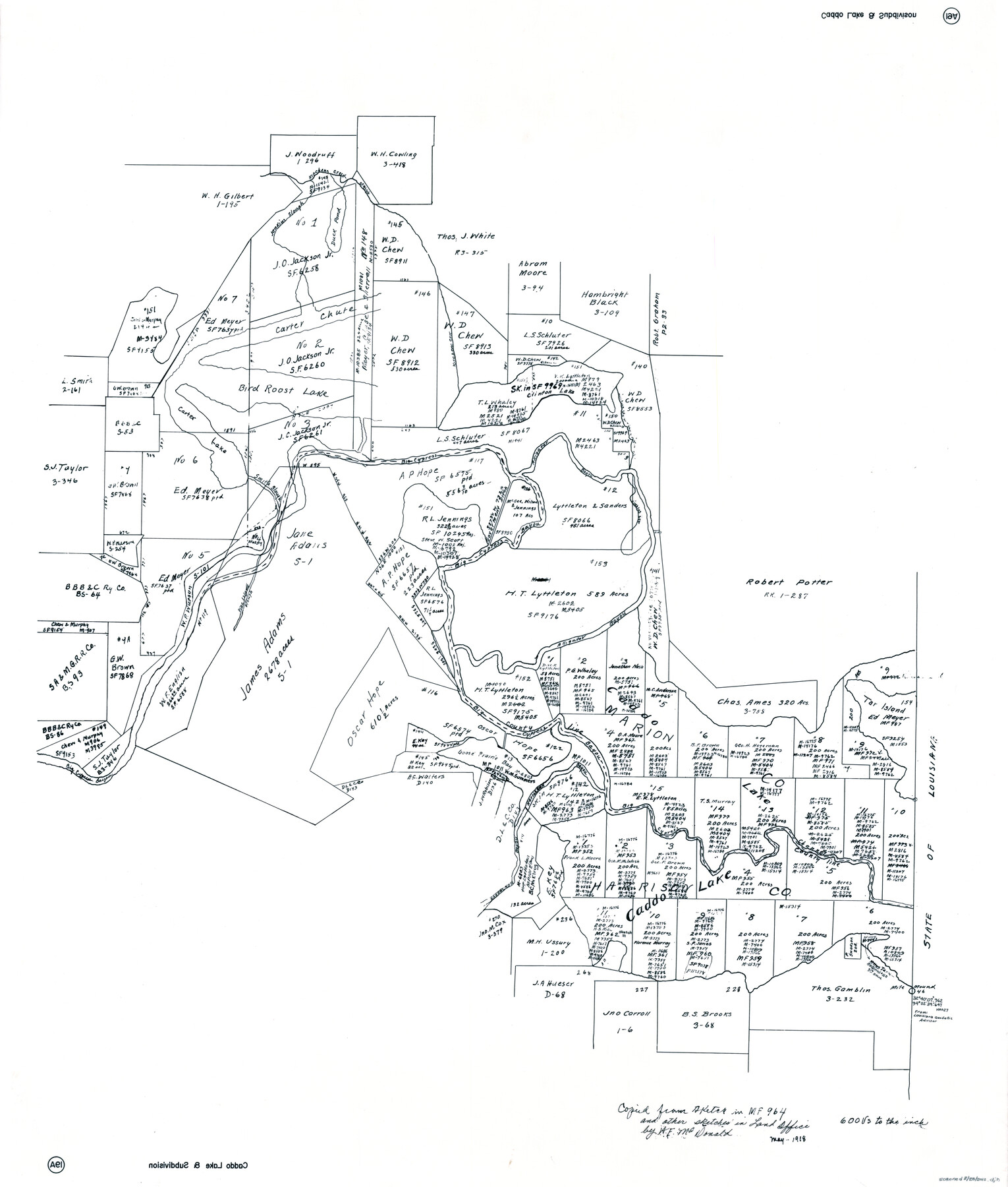
Caddo Lake and Subdivision
-
Map/Doc
93283
-
Collection
General Map Collection
-
Object Dates
1918 (Creation Date)
-
People and Organizations
A.F. McDonald (Draftsman)
-
Counties
Harrison Marion
-
Height x Width
35.0 x 29.8 inches
88.9 x 75.7 cm
-
Medium
mylar, rolled
-
Scale
600 varas
-
Comments
Copied from sketch in MF 964 and other sketches in Land Office
Part of: General Map Collection
Flight Mission No. BRA-9M, Frame 64, Jefferson County

Print $20.00
- Digital $50.00
Flight Mission No. BRA-9M, Frame 64, Jefferson County
1953
Size 18.6 x 22.4 inches
Map/Doc 85647
Bailey County Sketch File 15

Print $18.00
- Digital $50.00
Bailey County Sketch File 15
1912
Size 8.7 x 11.2 inches
Map/Doc 13975
Morris County Rolled Sketch 2A

Print $20.00
- Digital $50.00
Morris County Rolled Sketch 2A
Size 24.0 x 18.8 inches
Map/Doc 10257
Hopkins County

Print $20.00
- Digital $50.00
Hopkins County
1942
Size 44.1 x 40.9 inches
Map/Doc 73183
Flight Mission No. DQO-1K, Frame 147, Galveston County

Print $20.00
- Digital $50.00
Flight Mission No. DQO-1K, Frame 147, Galveston County
1952
Size 18.8 x 22.4 inches
Map/Doc 85000
Aransas County Sketch File B

Print $4.00
- Digital $50.00
Aransas County Sketch File B
Size 6.9 x 11.4 inches
Map/Doc 13216
Hutchinson County Working Sketch 7

Print $20.00
- Digital $50.00
Hutchinson County Working Sketch 7
1917
Size 16.5 x 11.9 inches
Map/Doc 66365
Navarro County Sketch File 10

Print $4.00
- Digital $50.00
Navarro County Sketch File 10
1860
Size 12.6 x 8.2 inches
Map/Doc 32318
Cooke County Sketch File 46

Print $36.00
- Digital $50.00
Cooke County Sketch File 46
2002
Size 10.5 x 8.0 inches
Map/Doc 82578
Tom Green County Rolled Sketch 14

Print $20.00
- Digital $50.00
Tom Green County Rolled Sketch 14
1953
Size 28.3 x 30.9 inches
Map/Doc 7999
Fannin County Sketch File 26

Print $4.00
- Digital $50.00
Fannin County Sketch File 26
1873
Size 8.5 x 10.3 inches
Map/Doc 22495
Liberty County Working Sketch 5

Print $20.00
- Digital $50.00
Liberty County Working Sketch 5
1901
Size 41.9 x 36.5 inches
Map/Doc 70464
You may also like
Loving County Working Sketch 15

Print $20.00
- Digital $50.00
Loving County Working Sketch 15
1973
Size 47.3 x 34.5 inches
Map/Doc 70648
General Highway Map, Wheeler County, Texas

Print $20.00
General Highway Map, Wheeler County, Texas
1940
Size 18.4 x 24.8 inches
Map/Doc 79276
Map of San Jacinto County

Print $20.00
- Digital $50.00
Map of San Jacinto County
1872
Size 22.0 x 18.6 inches
Map/Doc 1346
Webb County Sketch File 14-1

Print $6.00
- Digital $50.00
Webb County Sketch File 14-1
1892
Size 14.4 x 9.1 inches
Map/Doc 39814
Presidio County Sketch File 47

Print $16.00
- Digital $50.00
Presidio County Sketch File 47
1918
Size 7.2 x 8.1 inches
Map/Doc 34574
Harris County Rolled Sketch 86

Print $20.00
- Digital $50.00
Harris County Rolled Sketch 86
1933
Size 33.5 x 32.4 inches
Map/Doc 73575
Jno. B. Slaughter US Ranch situated in Garza County, Texas

Print $40.00
- Digital $50.00
Jno. B. Slaughter US Ranch situated in Garza County, Texas
Size 34.6 x 49.2 inches
Map/Doc 89946
![78444, [Webb County], General Map Collection](https://historictexasmaps.com/wmedia_w700/maps/78444.tif.jpg)
Americae Sive Novi Orbis, Nova Descriptio

Print $20.00
- Digital $50.00
Americae Sive Novi Orbis, Nova Descriptio
1573
Size 15.6 x 22.3 inches
Map/Doc 95834
Pecos County Rolled Sketch 128A
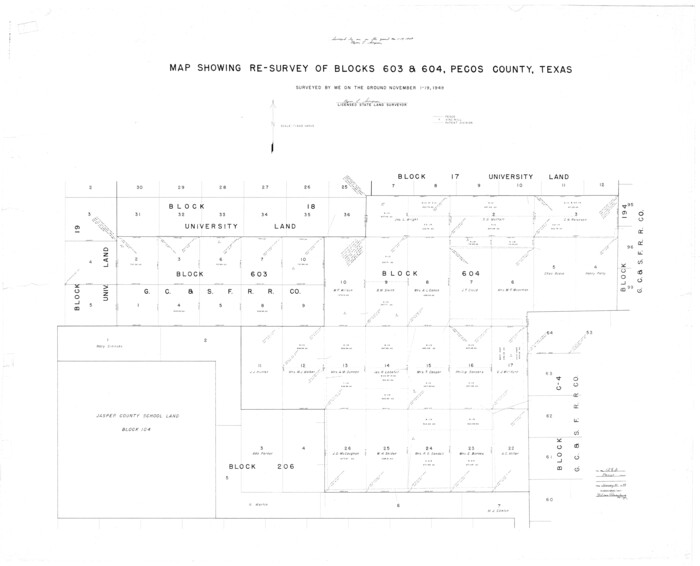
Print $40.00
- Digital $50.00
Pecos County Rolled Sketch 128A
1949
Size 43.3 x 53.5 inches
Map/Doc 10730
Hood County Sketch File 19

Print $11.00
- Digital $50.00
Hood County Sketch File 19
Size 9.0 x 7.9 inches
Map/Doc 26603
Hood County Rolled Sketch 3

Print $20.00
- Digital $50.00
Hood County Rolled Sketch 3
1967
Size 33.2 x 36.2 inches
Map/Doc 9179