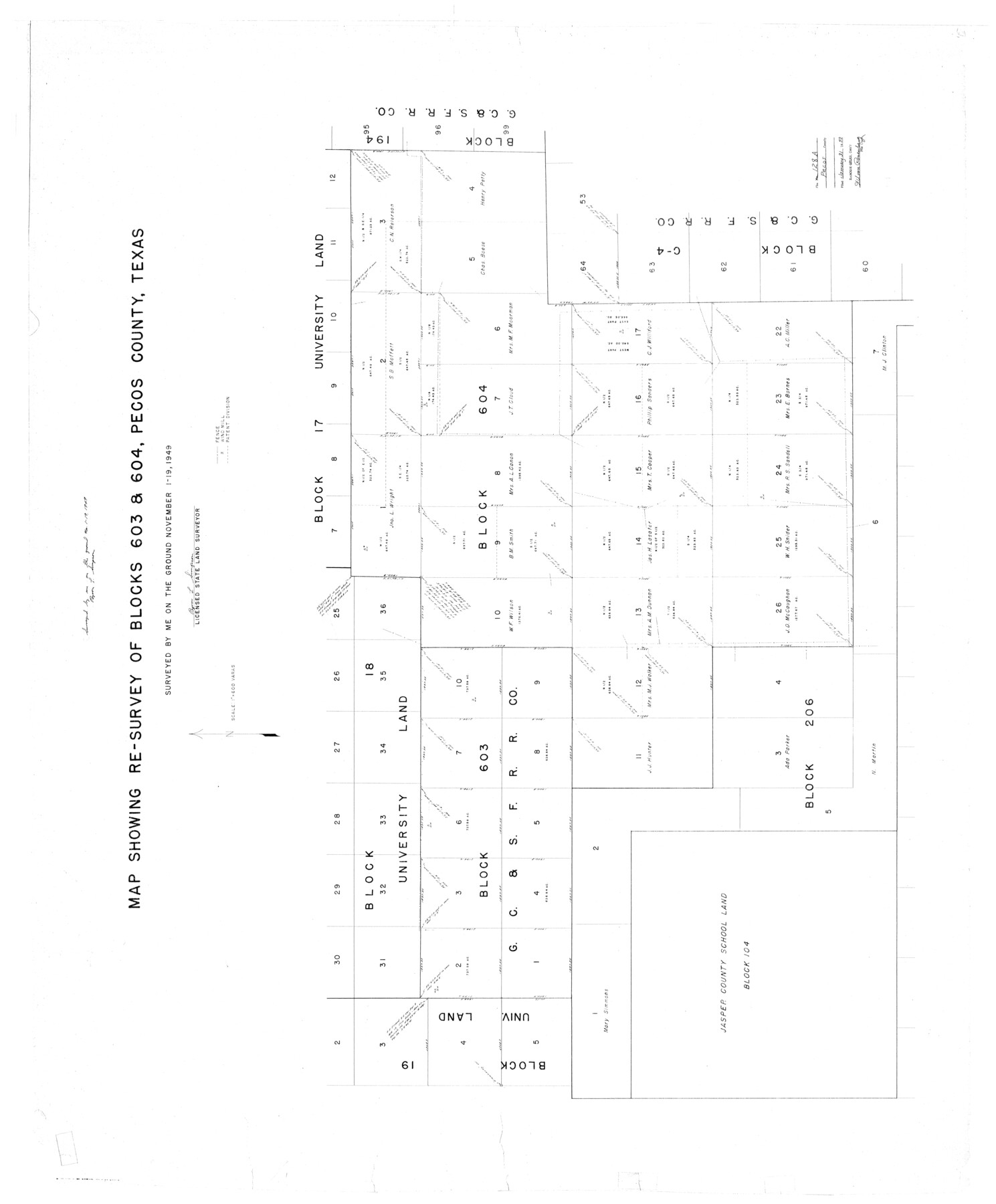
Pecos County Rolled Sketch 128A
Map showing re-survey of Blocks 603 & 604, Pecos County, Texas
-
Map/Doc
10730
-
Collection
General Map Collection
-
Object Dates
1949/11/19 (Survey Date)
1950/1/31 (File Date)
-
People and Organizations
Byron L. Simpson (Surveyor/Engineer)
-
Counties
Pecos
-
Subjects
Surveying Rolled Sketch
-
Height x Width
54.5 x 45.0 inches
138.4 x 114.3 cm
-
Scale
1" = 600 varas
Part of: General Map Collection
Moore County Working Sketch 6

Print $20.00
- Digital $50.00
Moore County Working Sketch 6
1921
Size 16.0 x 14.5 inches
Map/Doc 71188
Randall County Working Sketch 1

Print $20.00
- Digital $50.00
Randall County Working Sketch 1
1974
Size 28.0 x 31.6 inches
Map/Doc 71838
Current Miscellaneous File 110

Print $62.00
- Digital $50.00
Current Miscellaneous File 110
1972
Size 11.1 x 8.8 inches
Map/Doc 74713
Bell County Sketch File 9

Print $4.00
- Digital $50.00
Bell County Sketch File 9
Size 10.0 x 8.2 inches
Map/Doc 14379
Duval County Sketch File 58

Print $20.00
- Digital $50.00
Duval County Sketch File 58
1940
Size 18.3 x 19.0 inches
Map/Doc 11406
Crockett County Working Sketch 12

Print $20.00
- Digital $50.00
Crockett County Working Sketch 12
1915
Size 19.3 x 15.4 inches
Map/Doc 68345
Hutchinson County Rolled Sketch 40

Print $20.00
- Digital $50.00
Hutchinson County Rolled Sketch 40
1981
Size 25.7 x 37.4 inches
Map/Doc 6297
Falls County Working Sketch 2

Print $20.00
- Digital $50.00
Falls County Working Sketch 2
1922
Size 19.0 x 30.0 inches
Map/Doc 69177
Sterling County Rolled Sketch 36

Print $20.00
- Digital $50.00
Sterling County Rolled Sketch 36
Size 24.2 x 38.0 inches
Map/Doc 7860
Flight Mission No. BQR-20K, Frame 10, Brazoria County

Print $20.00
- Digital $50.00
Flight Mission No. BQR-20K, Frame 10, Brazoria County
1952
Size 18.6 x 22.3 inches
Map/Doc 84112
Map of Parker County

Print $20.00
- Digital $50.00
Map of Parker County
1871
Size 20.9 x 18.4 inches
Map/Doc 3942
Uvalde County Sketch File 33

Print $56.00
- Digital $50.00
Uvalde County Sketch File 33
2017
Size 11.0 x 8.5 inches
Map/Doc 95251
You may also like
Wise County Sketch File 42

Print $4.00
- Digital $50.00
Wise County Sketch File 42
1876
Size 8.0 x 6.5 inches
Map/Doc 40601
Dawson County, Texas

Print $20.00
- Digital $50.00
Dawson County, Texas
1880
Size 28.6 x 20.5 inches
Map/Doc 705
Winkler County Sketch File 14

Print $20.00
- Digital $50.00
Winkler County Sketch File 14
Size 29.4 x 24.3 inches
Map/Doc 12698
Terrell County Working Sketch 84d

Print $20.00
- Digital $50.00
Terrell County Working Sketch 84d
1992
Size 18.4 x 31.5 inches
Map/Doc 69608
[J. Poitevent Blk. 1]
![90132, [J. Poitevent Blk. 1], Twichell Survey Records](https://historictexasmaps.com/wmedia_w700/maps/90132-1.tif.jpg)
Print $3.00
- Digital $50.00
[J. Poitevent Blk. 1]
Size 10.7 x 13.3 inches
Map/Doc 90132
Flight Mission No. BRA-17M, Frame 11, Jefferson County

Print $20.00
- Digital $50.00
Flight Mission No. BRA-17M, Frame 11, Jefferson County
1953
Size 18.4 x 22.2 inches
Map/Doc 85792
Gregg County Rolled Sketch 7

Print $20.00
- Digital $50.00
Gregg County Rolled Sketch 7
1933
Size 24.6 x 42.0 inches
Map/Doc 6032
[Tom Green County]
![82060, [Tom Green County], General Map Collection](https://historictexasmaps.com/wmedia_w700/maps/82060.tif.jpg)
Print $40.00
- Digital $50.00
[Tom Green County]
1888
Size 45.8 x 113.0 inches
Map/Doc 82060
Crosby County

Print $20.00
- Digital $50.00
Crosby County
1892
Size 13.2 x 15.4 inches
Map/Doc 90495
Red River County Working Sketch 25

Print $20.00
- Digital $50.00
Red River County Working Sketch 25
1959
Size 23.0 x 22.2 inches
Map/Doc 72008
Webb County Working Sketch 89

Print $20.00
- Digital $50.00
Webb County Working Sketch 89
1982
Size 44.6 x 43.0 inches
Map/Doc 72456
Newton County Working Sketch 17

Print $20.00
- Digital $50.00
Newton County Working Sketch 17
1950
Size 15.1 x 23.0 inches
Map/Doc 71263