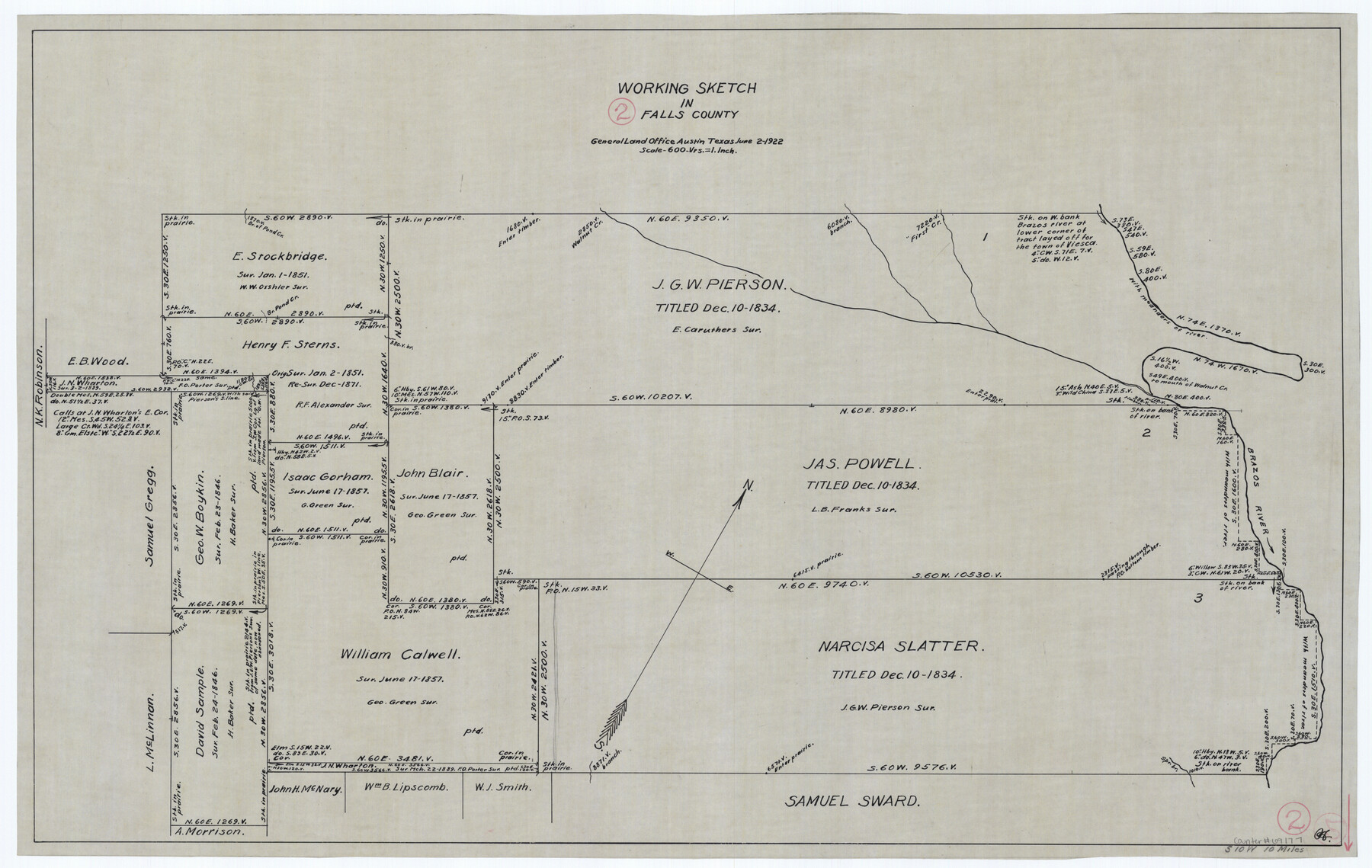
Falls County Working Sketch 2
-
Map/Doc
69177
-
Collection
General Map Collection
-
Object Dates
6/2/1922 (Creation Date)
-
Counties
Falls
-
Subjects
Surveying Working Sketch
-
Height x Width
19.0 x 30.0 inches
48.3 x 76.2 cm
-
Scale
1" = 600 varas
Part of: General Map Collection
Upshur County Rolled Sketch 5

Print $20.00
- Digital $50.00
Upshur County Rolled Sketch 5
2000
Size 35.2 x 24.4 inches
Map/Doc 8064
Val Verde County Sketch File 41

Print $20.00
- Digital $50.00
Val Verde County Sketch File 41
1938
Size 17.8 x 22.7 inches
Map/Doc 12583
Liberty County Rolled Sketch JP2

Print $40.00
- Digital $50.00
Liberty County Rolled Sketch JP2
1935
Size 52.0 x 12.5 inches
Map/Doc 9568
Interfaith's Official Map: The Woodlands, a real hometown for people and companies

Interfaith's Official Map: The Woodlands, a real hometown for people and companies
1997
Size 22.4 x 36.5 inches
Map/Doc 94286

Dawson County Sketch File 29

Print $4.00
- Digital $50.00
Dawson County Sketch File 29
1892
Size 11.3 x 9.0 inches
Map/Doc 20592
Edwards County Working Sketch 19

Print $20.00
- Digital $50.00
Edwards County Working Sketch 19
1934
Size 24.1 x 24.6 inches
Map/Doc 68895
Flight Mission No. CGI-3N, Frame 111, Cameron County

Print $20.00
- Digital $50.00
Flight Mission No. CGI-3N, Frame 111, Cameron County
1954
Size 18.6 x 22.2 inches
Map/Doc 84591
Webb County Working Sketch 48

Print $20.00
- Digital $50.00
Webb County Working Sketch 48
1948
Size 28.5 x 41.4 inches
Map/Doc 72413
From Aransas Pass Eastward, Texas

Print $40.00
- Digital $50.00
From Aransas Pass Eastward, Texas
1866
Size 32.1 x 53.4 inches
Map/Doc 73427
The Republic of Texas, March 2, 1836 - February 19, 1846

The Republic of Texas, March 2, 1836 - February 19, 1846
1972
Size 23.4 x 18.3 inches
Map/Doc 2109
Hidalgo County Rolled Sketch 17

Print $40.00
- Digital $50.00
Hidalgo County Rolled Sketch 17
1963
Size 68.4 x 42.9 inches
Map/Doc 9172
You may also like
Tarrant County Working Sketch 8

Print $20.00
- Digital $50.00
Tarrant County Working Sketch 8
1982
Size 33.2 x 19.7 inches
Map/Doc 62425
Map from the Sabine River to the Rio Grande as subdivided for mineral development

Print $20.00
- Digital $50.00
Map from the Sabine River to the Rio Grande as subdivided for mineral development
Size 30.6 x 44.8 inches
Map/Doc 65801
Hamilton County Sketch File 4

Print $16.00
- Digital $50.00
Hamilton County Sketch File 4
Size 14.5 x 9.1 inches
Map/Doc 24903
Flight Mission No. DCL-7C, Frame 119, Kenedy County

Print $20.00
- Digital $50.00
Flight Mission No. DCL-7C, Frame 119, Kenedy County
1943
Size 18.5 x 22.3 inches
Map/Doc 86084
Reagan County Working Sketch 14a

Print $20.00
- Digital $50.00
Reagan County Working Sketch 14a
1949
Size 25.9 x 15.2 inches
Map/Doc 71854
Grayson County Sketch File 16

Print $6.00
- Digital $50.00
Grayson County Sketch File 16
Size 11.3 x 8.4 inches
Map/Doc 24484
Flight Mission No. DCL-6C, Frame 118, Kenedy County

Print $20.00
- Digital $50.00
Flight Mission No. DCL-6C, Frame 118, Kenedy County
1943
Size 18.6 x 22.4 inches
Map/Doc 85948
Williamson County Sketch File 15

Print $4.00
- Digital $50.00
Williamson County Sketch File 15
Size 10.0 x 8.0 inches
Map/Doc 40334
Map of Winkler County

Print $20.00
- Digital $50.00
Map of Winkler County
1901
Size 43.1 x 36.6 inches
Map/Doc 4158
San Patricio County Sketch File 49

Print $84.00
- Digital $50.00
San Patricio County Sketch File 49
1934
Size 9.1 x 11.4 inches
Map/Doc 36329

[Right of Way & Track Map, The Texas & Pacific Ry. Co. Main Line]
![64669, [Right of Way & Track Map, The Texas & Pacific Ry. Co. Main Line], General Map Collection](https://historictexasmaps.com/wmedia_w700/maps/64669.tif.jpg)
Print $20.00
- Digital $50.00
[Right of Way & Track Map, The Texas & Pacific Ry. Co. Main Line]
Size 11.0 x 18.5 inches
Map/Doc 64669