Grayson County Sketch File 16
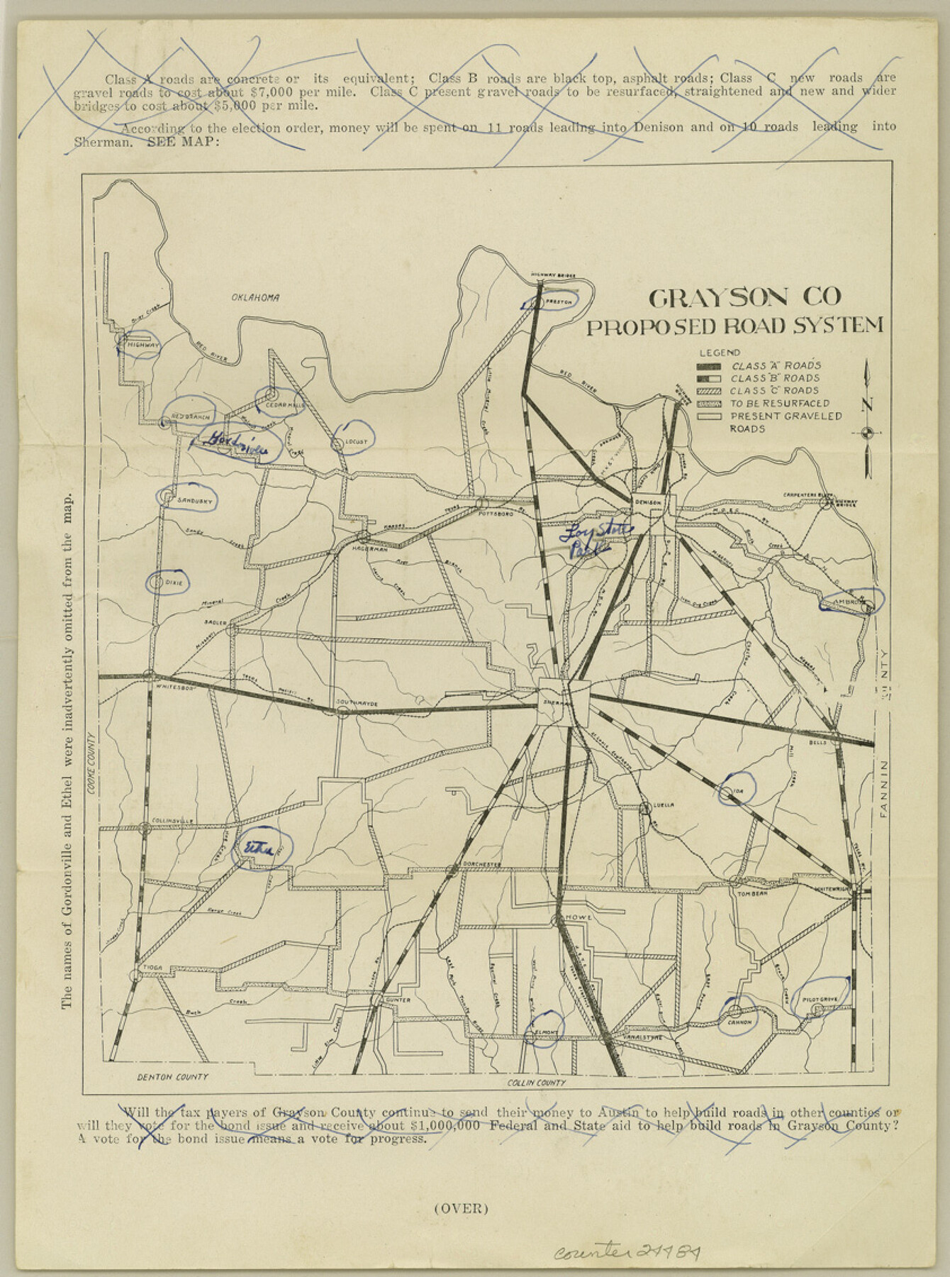
[Map showing proposed road system of Grayson County]
-
Map/Doc
24484
-
Collection
General Map Collection
-
Object Dates
1935/4/12 (File Date)
-
People and Organizations
Jake J. Loy (Surveyor/Engineer)
-
Counties
Grayson
-
Subjects
Surveying Sketch File
-
Height x Width
11.3 x 8.4 inches
28.7 x 21.3 cm
-
Medium
multi-page, multi-format
-
Features
East Fork of Trinity River
Ida
Tombean
Bells
Luella
Howe
Pilot Grove
Cannon
Dorchester
Sherman
Elmont
Gunter
Collinsville
Tioga
Van Alstyne
Gordonville
Ethel
Red River
Southrayde
Sadler
Whitesboro
Sandusky
Walnut Creek
Cedar Mills
Loy State Park
Hagerman
Denison
Pottsboro
Ambrose
Carpenters Bluff
Preston
Highway Bridge
Bear Creek
Part of: General Map Collection
Hardin County Sketch File 59

Print $6.00
- Digital $50.00
Hardin County Sketch File 59
Size 16.8 x 11.6 inches
Map/Doc 25233
Medina County Working Sketch 8

Print $20.00
- Digital $50.00
Medina County Working Sketch 8
1955
Size 23.4 x 18.4 inches
Map/Doc 70923
Fort Bend County

Print $20.00
- Digital $50.00
Fort Bend County
1865
Size 18.2 x 21.8 inches
Map/Doc 3550
Galveston County NRC Article 33.136 Sketch 85

Print $42.00
- Digital $50.00
Galveston County NRC Article 33.136 Sketch 85
2015
Size 36.4 x 24.5 inches
Map/Doc 94965
Galveston Bay Entrance - Galveston and Texas City Harbors

Print $40.00
- Digital $50.00
Galveston Bay Entrance - Galveston and Texas City Harbors
1992
Size 37.1 x 55.6 inches
Map/Doc 69866
La Salle County Working Sketch 27

Print $20.00
- Digital $50.00
La Salle County Working Sketch 27
1949
Size 15.2 x 23.6 inches
Map/Doc 70328
Brewster County Rolled Sketch 23

Print $20.00
- Digital $50.00
Brewster County Rolled Sketch 23
Size 24.5 x 24.8 inches
Map/Doc 5207
Archer County Sketch File 17

Print $4.00
- Digital $50.00
Archer County Sketch File 17
1901
Size 11.3 x 8.6 inches
Map/Doc 13653
Comal County Working Sketch 11

Print $20.00
- Digital $50.00
Comal County Working Sketch 11
1978
Size 33.2 x 35.2 inches
Map/Doc 68177
Gaines County Rolled Sketch 35

Print $20.00
- Digital $50.00
Gaines County Rolled Sketch 35
2014
Size 18.7 x 25.9 inches
Map/Doc 93695
El Paso County Sketch File 27

Print $20.00
- Digital $50.00
El Paso County Sketch File 27
Size 18.3 x 24.5 inches
Map/Doc 11458
Montgomery County Rolled Sketch 42

Print $20.00
- Digital $50.00
Montgomery County Rolled Sketch 42
1939
Size 14.2 x 20.5 inches
Map/Doc 6817
You may also like
[T. & P. Blocks 31-33, Township 5N]
![90568, [T. & P. Blocks 31-33, Township 5N], Twichell Survey Records](https://historictexasmaps.com/wmedia_w700/maps/90568-1.tif.jpg)
Print $20.00
- Digital $50.00
[T. & P. Blocks 31-33, Township 5N]
Size 14.6 x 17.7 inches
Map/Doc 90568

Mills County Sketch File 14a

Print $4.00
- Digital $50.00
Mills County Sketch File 14a
Size 13.0 x 8.2 inches
Map/Doc 31663
Lubbock County

Print $20.00
- Digital $50.00
Lubbock County
1915
Size 46.1 x 40.0 inches
Map/Doc 66911

Irion County Sketch File 11

Print $20.00
- Digital $50.00
Irion County Sketch File 11
1937
Size 22.2 x 17.5 inches
Map/Doc 11826
Flight Mission No. BRA-16M, Frame 143, Jefferson County

Print $20.00
- Digital $50.00
Flight Mission No. BRA-16M, Frame 143, Jefferson County
1953
Size 18.5 x 22.2 inches
Map/Doc 85749
Atascosa County Sketch File 27c

Print $12.00
- Digital $50.00
Atascosa County Sketch File 27c
1876
Size 12.7 x 8.4 inches
Map/Doc 13806
Plat of 83.94 acre vacant tract of land showing connections to adjoining surveys

Print $20.00
- Digital $50.00
Plat of 83.94 acre vacant tract of land showing connections to adjoining surveys
1918
Size 17.7 x 21.1 inches
Map/Doc 90823
Crockett County Sketch File 53

Print $10.00
- Digital $50.00
Crockett County Sketch File 53
1903
Size 11.4 x 8.9 inches
Map/Doc 19819
Jeff Davis County Rolled Sketch 16

Print $20.00
- Digital $50.00
Jeff Davis County Rolled Sketch 16
Size 27.1 x 31.7 inches
Map/Doc 6369
[Sketch showing parts of Blocks 3, 5, 22, M-20, S, T and Block BB, surveys 1, 2 and 3]
![91729, [Sketch showing parts of Blocks 3, 5, 22, M-20, S, T and Block BB, surveys 1, 2 and 3], Twichell Survey Records](https://historictexasmaps.com/wmedia_w700/maps/91729-1.tif.jpg)
Print $20.00
- Digital $50.00
[Sketch showing parts of Blocks 3, 5, 22, M-20, S, T and Block BB, surveys 1, 2 and 3]
Size 15.9 x 15.3 inches
Map/Doc 91729