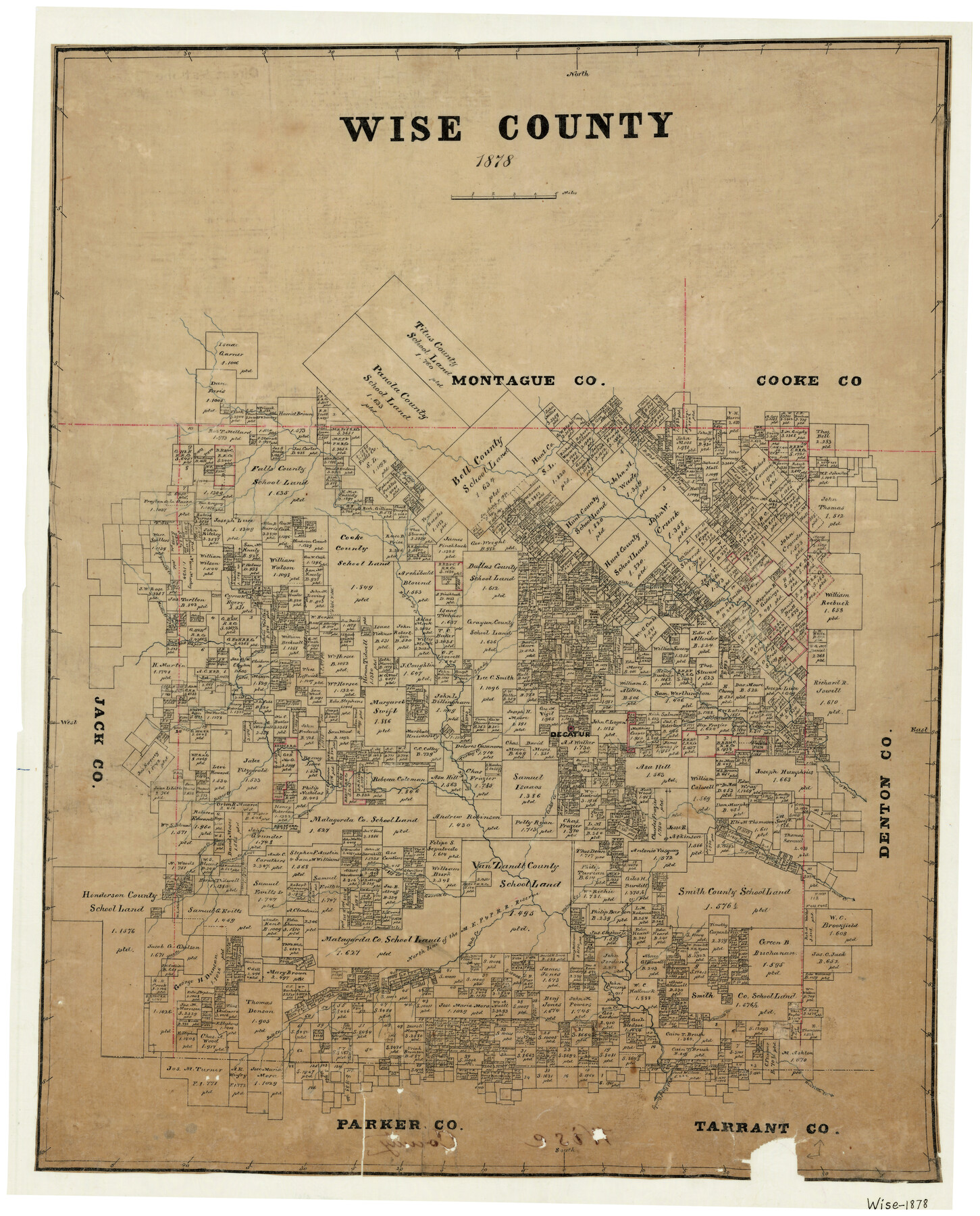
Wise County
-
Map/Doc
4161
-
Collection
General Map Collection
-
Object Dates
1878 (Creation Date)
-
Counties
Wise
-
Subjects
County
-
Height x Width
27.2 x 21.6 inches
69.1 x 54.9 cm
-
Features
Salt Creek
Thompson Creek
Willow Creek
Bean Creek
Garrett Creek
Vale Creek
Walnut Creek
Deep Creek
Oliver Creek
Boggy Creek
Rock Creek
Durrett Creek
Henriette Creek
West Fork of Trinity River
Trinity River
Caddles Creek
Salt Ford [of Vale Creek]
Blake Creek
Bennett Creek
Center Creek
Gentry Creek
Jasper Creek
Barns Creek
Turkey Creek
Decatur
Denton Fork of Trinity River
Long Branch [of Catlett Creek]
West Fork of Martin Creek
Mountain Creek
Martin Creek
McCoy Creek
Big Sandy Creek
Sandy Creek
Part of: General Map Collection
McLennan County Working Sketch 6

Print $20.00
- Digital $50.00
McLennan County Working Sketch 6
1957
Size 26.7 x 24.8 inches
Map/Doc 70699
Texas Gulf Coast, from the Sabine River to the Rio Grande as Subdivided for Mineral Development; Galveston, Brazoria and Matagorda Counties

Print $40.00
- Digital $50.00
Texas Gulf Coast, from the Sabine River to the Rio Grande as Subdivided for Mineral Development; Galveston, Brazoria and Matagorda Counties
1976
Size 43.8 x 69.3 inches
Map/Doc 1938
Medina County Rolled Sketch 17

Print $20.00
- Digital $50.00
Medina County Rolled Sketch 17
1979
Size 32.3 x 18.9 inches
Map/Doc 6750
Shelby County

Print $20.00
- Digital $50.00
Shelby County
1945
Size 42.7 x 46.9 inches
Map/Doc 95639
Red River County Rolled Sketch 3

Print $20.00
- Digital $50.00
Red River County Rolled Sketch 3
Size 36.9 x 31.0 inches
Map/Doc 9840
Cameron County Rolled Sketch 19

Print $20.00
- Digital $50.00
Cameron County Rolled Sketch 19
1960
Size 27.0 x 20.5 inches
Map/Doc 5469
Maps of Gulf Intracoastal Waterway, Texas - Sabine River to the Rio Grande and connecting waterways including ship channels

Print $20.00
- Digital $50.00
Maps of Gulf Intracoastal Waterway, Texas - Sabine River to the Rio Grande and connecting waterways including ship channels
1966
Size 14.6 x 22.4 inches
Map/Doc 61953
Flight Mission No. CGI-3N, Frame 47, Cameron County

Print $20.00
- Digital $50.00
Flight Mission No. CGI-3N, Frame 47, Cameron County
1954
Size 18.7 x 22.3 inches
Map/Doc 84553
Travis County Rolled Sketch 46

Print $20.00
- Digital $50.00
Travis County Rolled Sketch 46
1966
Size 25.4 x 37.6 inches
Map/Doc 8043
Val Verde County Working Sketch 72

Print $20.00
- Digital $50.00
Val Verde County Working Sketch 72
1967
Size 19.6 x 23.0 inches
Map/Doc 72207
Bastrop County Sketch File 7

Print $40.00
- Digital $50.00
Bastrop County Sketch File 7
Size 13.2 x 12.4 inches
Map/Doc 14052

You may also like
Freestone County Sketch File 6

Print $4.00
- Digital $50.00
Freestone County Sketch File 6
1858
Size 10.3 x 8.8 inches
Map/Doc 23050
Outer Continental Shelf Leasing Maps (Texas Offshore Operations)

Print $20.00
- Digital $50.00
Outer Continental Shelf Leasing Maps (Texas Offshore Operations)
Size 24.0 x 18.4 inches
Map/Doc 75853
Texas State Boundary Line 9

Print $174.00
Texas State Boundary Line 9
2000
Size 11.3 x 8.8 inches
Map/Doc 75076
Pecos County Working Sketch 133

Print $20.00
- Digital $50.00
Pecos County Working Sketch 133
1979
Size 44.0 x 37.2 inches
Map/Doc 71607
Gonzales County Rolled Sketch 1

Print $20.00
- Digital $50.00
Gonzales County Rolled Sketch 1
1917
Size 21.9 x 23.9 inches
Map/Doc 6027

Nueces County Rolled Sketch 38

Print $458.00
- Digital $50.00
Nueces County Rolled Sketch 38
Size 10.1 x 16.4 inches
Map/Doc 47717
Travis County Appraisal District Plat Map 2_2105

Print $20.00
- Digital $50.00
Travis County Appraisal District Plat Map 2_2105
Size 21.6 x 26.5 inches
Map/Doc 94200
Flight Mission No. DIX-5P, Frame 114, Aransas County

Print $20.00
- Digital $50.00
Flight Mission No. DIX-5P, Frame 114, Aransas County
1956
Size 17.4 x 17.6 inches
Map/Doc 83793
[Surveys along Bray's Bayou]
![157, [Surveys along Bray's Bayou], General Map Collection](https://historictexasmaps.com/wmedia_w700/maps/157.tif.jpg)
Print $2.00
- Digital $50.00
[Surveys along Bray's Bayou]
Size 7.6 x 4.9 inches
Map/Doc 157
Bastrop County Rolled Sketch 2

Print $20.00
- Digital $50.00
Bastrop County Rolled Sketch 2
1979
Size 26.3 x 18.4 inches
Map/Doc 5123
Flight Mission No. CRC-4R, Frame 79, Chambers County

Print $20.00
- Digital $50.00
Flight Mission No. CRC-4R, Frame 79, Chambers County
1956
Size 18.9 x 22.6 inches
Map/Doc 84883