Bastrop County Sketch File 7
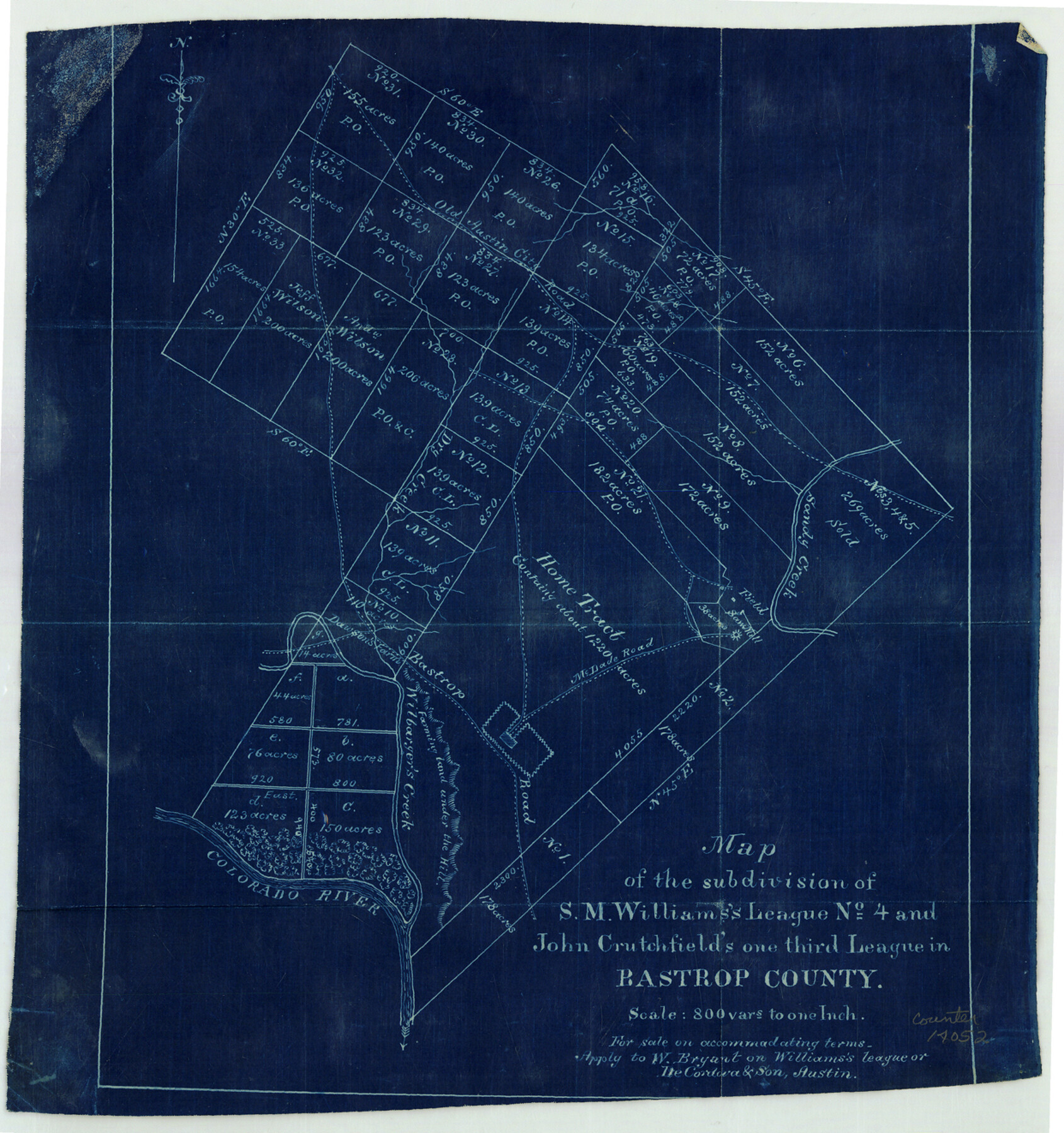
Map of the subdivision of S.M. Williams's League no. 4 and John Crutchfield's one third League in Bastrop County
-
Map/Doc
14052
-
Collection
General Map Collection
-
Counties
Bastrop
-
Subjects
Surveying Sketch File
-
Height x Width
13.2 x 12.4 inches
33.5 x 31.5 cm
-
Medium
blueprint/diazo
-
Features
Old Austin City Road
Bastrop
McDade Road
Saw Mill
Bastrop Road
Wilbarger's Creek
Dawson's Farm
Colorado River
Part of: General Map Collection
Port of Galveston, Galveston Channel

Print $40.00
- Digital $50.00
Port of Galveston, Galveston Channel
1979
Size 38.0 x 66.2 inches
Map/Doc 83333
Stonewall County Sketch File 22

Print $20.00
- Digital $50.00
Stonewall County Sketch File 22
1937
Size 18.8 x 23.1 inches
Map/Doc 12368
Map of Oregon, Kansas, California, and the Territories

Print $20.00
- Digital $50.00
Map of Oregon, Kansas, California, and the Territories
1885
Size 9.0 x 12.2 inches
Map/Doc 93522
Trinity County Sketch File 34

Print $20.00
- Digital $50.00
Trinity County Sketch File 34
Size 15.9 x 20.3 inches
Map/Doc 12491
Galveston County Rolled Sketch 27

Print $20.00
- Digital $50.00
Galveston County Rolled Sketch 27
1978
Size 29.6 x 33.3 inches
Map/Doc 10301
Red River County Working Sketch 74

Print $20.00
- Digital $50.00
Red River County Working Sketch 74
1980
Size 24.2 x 22.8 inches
Map/Doc 72057
Lee County Working Sketch 19

Print $20.00
- Digital $50.00
Lee County Working Sketch 19
1991
Size 33.1 x 20.1 inches
Map/Doc 70398
Shelby County Rolled Sketch 7

Print $40.00
- Digital $50.00
Shelby County Rolled Sketch 7
1945
Size 61.1 x 44.4 inches
Map/Doc 9922
Clarkson's City Map of Port Aransas

Print $20.00
- Digital $50.00
Clarkson's City Map of Port Aransas
Size 18.5 x 26.5 inches
Map/Doc 3040
Terrell County Rolled Sketch 12

Print $20.00
- Digital $50.00
Terrell County Rolled Sketch 12
Size 37.1 x 31.5 inches
Map/Doc 7926
Webb County Sketch File 11-1

Print $8.00
- Digital $50.00
Webb County Sketch File 11-1
1884
Size 11.3 x 8.5 inches
Map/Doc 39781
Panola County Working Sketch 28

Print $20.00
- Digital $50.00
Panola County Working Sketch 28
1977
Map/Doc 71437
You may also like
El Paso County Working Sketch 47

Print $20.00
- Digital $50.00
El Paso County Working Sketch 47
Size 28.3 x 30.5 inches
Map/Doc 69069
Fayette County Working Sketch 9

Print $20.00
- Digital $50.00
Fayette County Working Sketch 9
1981
Size 34.4 x 32.3 inches
Map/Doc 69173
General Highway Map, Hood County, Somervell County, Texas

Print $20.00
General Highway Map, Hood County, Somervell County, Texas
1940
Size 18.3 x 24.8 inches
Map/Doc 79131
Collingsworth County Working Sketch 5

Print $20.00
- Digital $50.00
Collingsworth County Working Sketch 5
1973
Size 22.5 x 38.2 inches
Map/Doc 68093
Crockett County Working Sketch 74

Print $20.00
- Digital $50.00
Crockett County Working Sketch 74
1964
Size 29.4 x 22.1 inches
Map/Doc 68407
Young County Working Sketch 28

Print $20.00
- Digital $50.00
Young County Working Sketch 28
1985
Size 29.9 x 26.0 inches
Map/Doc 62051
Harris County Boundary File 39 (16)

Print $6.00
- Digital $50.00
Harris County Boundary File 39 (16)
Size 10.0 x 8.0 inches
Map/Doc 54354
Bexar County Working Sketch 13

Print $20.00
- Digital $50.00
Bexar County Working Sketch 13
1968
Size 43.5 x 43.7 inches
Map/Doc 67329
Map of Hill County

Print $40.00
- Digital $50.00
Map of Hill County
1884
Size 48.4 x 37.7 inches
Map/Doc 4979
Menard County Rolled Sketch 2A

Print $20.00
- Digital $50.00
Menard County Rolled Sketch 2A
1905
Size 23.3 x 18.5 inches
Map/Doc 6753
Montague County Working Sketch 8

Print $20.00
- Digital $50.00
Montague County Working Sketch 8
1928
Size 20.9 x 18.9 inches
Map/Doc 71074
Chambers County Sketch File 39

Print $52.00
- Digital $50.00
Chambers County Sketch File 39
Size 11.0 x 6.6 inches
Map/Doc 17652