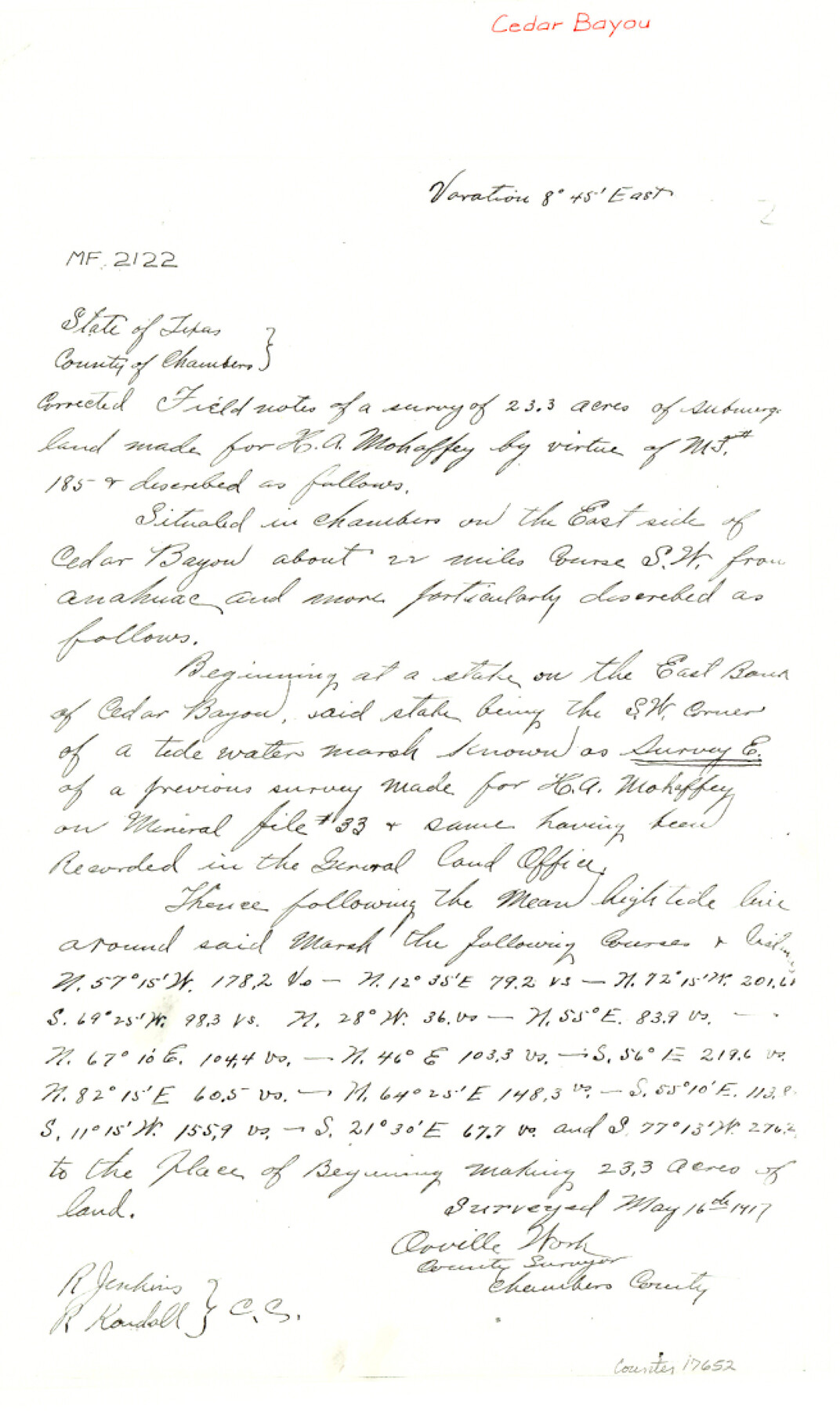
Chambers County Sketch File 39
[Copy of field notes and sketch for MF-2122, MF-2020, and MF-1931 all in Cedar Bayou]
-
Map/Doc
17652
-
Collection
General Map Collection
-
Object Dates
1917 (Survey Date)
1983/6/22 (File Date)
-
People and Organizations
Orville Work (Surveyor/Engineer)
-
Counties
Chambers
-
Subjects
Surveying Sketch File
-
Height x Width
11.0 x 6.6 inches
27.9 x 16.8 cm
-
Medium
paper, photocopy
-
Features
Cedar Bayou
Anahuac
Trinity Bay
Ashe's Lake
Ivan's Lake
Part of: General Map Collection
Clay County Working Sketch Graphic Index

Print $40.00
- Digital $50.00
Clay County Working Sketch Graphic Index
1971
Size 58.4 x 34.3 inches
Map/Doc 76494
Red River County Working Sketch 54

Print $20.00
- Digital $50.00
Red River County Working Sketch 54
1971
Size 19.3 x 31.1 inches
Map/Doc 72037
Jefferson County Rolled Sketch 64

Print $20.00
- Digital $50.00
Jefferson County Rolled Sketch 64
1982
Size 26.7 x 37.4 inches
Map/Doc 9319
Collingsworth County Sketch File 2

Print $20.00
- Digital $50.00
Collingsworth County Sketch File 2
1888
Size 24.3 x 31.3 inches
Map/Doc 11129
Motley County Working Sketch 8

Print $20.00
- Digital $50.00
Motley County Working Sketch 8
1983
Size 32.1 x 30.6 inches
Map/Doc 71213
Township No. 4 South Range No. 14 West of the Indian Meridian

Print $4.00
- Digital $50.00
Township No. 4 South Range No. 14 West of the Indian Meridian
1875
Size 18.0 x 22.4 inches
Map/Doc 75144
San Patricio County Sketch File 42

Print $89.00
- Digital $50.00
San Patricio County Sketch File 42
1979
Size 11.3 x 8.8 inches
Map/Doc 36240
Brewster County Working Sketch 54

Print $20.00
- Digital $50.00
Brewster County Working Sketch 54
1952
Size 23.7 x 37.0 inches
Map/Doc 67655
Gray County Boundary File 5

Print $6.00
- Digital $50.00
Gray County Boundary File 5
Size 11.9 x 9.4 inches
Map/Doc 53893
Hall County Working Sketch 4

Print $20.00
- Digital $50.00
Hall County Working Sketch 4
1923
Size 29.0 x 19.7 inches
Map/Doc 63332
Webb County Rolled Sketch 32

Print $20.00
- Digital $50.00
Webb County Rolled Sketch 32
1937
Size 24.9 x 21.8 inches
Map/Doc 8188
Flight Mission No. CUG-1P, Frame 55, Kleberg County

Print $20.00
- Digital $50.00
Flight Mission No. CUG-1P, Frame 55, Kleberg County
1956
Size 18.5 x 22.3 inches
Map/Doc 86133
You may also like
General Highway Map. Detail of Cities and Towns in Tarrant County, Texas [Fort Worth and vicinity]
![79252, General Highway Map. Detail of Cities and Towns in Tarrant County, Texas [Fort Worth and vicinity], Texas State Library and Archives](https://historictexasmaps.com/wmedia_w700/maps/79252-GC.tif.jpg)
Print $20.00
General Highway Map. Detail of Cities and Towns in Tarrant County, Texas [Fort Worth and vicinity]
1940
Size 24.9 x 18.2 inches
Map/Doc 79252
Coast Chart No. 211 - Padre I. and Laguna Madre Lat. 27° 12' to Lat. 26° 33' Texas

Print $20.00
- Digital $50.00
Coast Chart No. 211 - Padre I. and Laguna Madre Lat. 27° 12' to Lat. 26° 33' Texas
1890
Size 27.5 x 18.2 inches
Map/Doc 72822
![91447, [Block K5], Twichell Survey Records](https://historictexasmaps.com/wmedia_w700/maps/91447-1.tif.jpg)
Gray's New Map of Texas and the Indian Territory

Print $20.00
- Digital $50.00
Gray's New Map of Texas and the Indian Territory
1876
Size 17.6 x 28.6 inches
Map/Doc 97282
Hutchinson County Working Sketch 49

Print $20.00
- Digital $50.00
Hutchinson County Working Sketch 49
1988
Size 35.2 x 37.3 inches
Map/Doc 66409
Hockley County Map

Print $20.00
- Digital $50.00
Hockley County Map
Size 20.4 x 21.4 inches
Map/Doc 91195
Robertson County Sketch File 7

Print $20.00
Robertson County Sketch File 7
1873
Size 16.3 x 24.0 inches
Map/Doc 12250
Coast Chart No. 209 - Aransas Pass, Aransas and Copano Bays, Texas

Print $20.00
- Digital $50.00
Coast Chart No. 209 - Aransas Pass, Aransas and Copano Bays, Texas
1889
Size 31.2 x 24.9 inches
Map/Doc 73429
Morris County Rolled Sketch 2A

Print $20.00
- Digital $50.00
Morris County Rolled Sketch 2A
Size 24.3 x 19.2 inches
Map/Doc 10264
Flight Mission No. CRC-4R, Frame 100, Chambers County

Print $20.00
- Digital $50.00
Flight Mission No. CRC-4R, Frame 100, Chambers County
1956
Size 18.5 x 22.2 inches
Map/Doc 84897
Map of The Surveyed Part of Peters Colony Texas

Print $40.00
- Digital $50.00
Map of The Surveyed Part of Peters Colony Texas
1854
Size 53.1 x 33.9 inches
Map/Doc 83008
Reeves County Working Sketch 31

Print $20.00
- Digital $50.00
Reeves County Working Sketch 31
1969
Size 27.6 x 36.5 inches
Map/Doc 63474