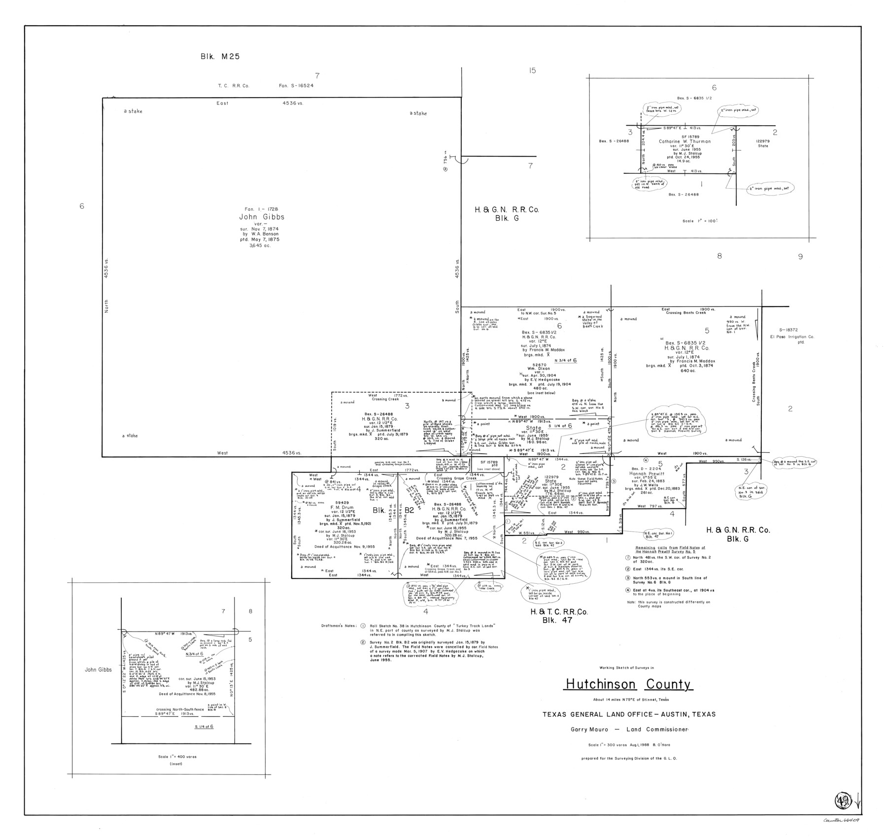
Hutchinson County Working Sketch 49
-
Map/Doc
66409
-
Collection
General Map Collection
-
Object Dates
8/1/1988 (Creation Date)
-
People and Organizations
Bill O'Hara (Draftsman)
-
Counties
Hutchinson
-
Subjects
Surveying Working Sketch
-
Height x Width
35.2 x 37.3 inches
89.4 x 94.7 cm
-
Scale
1" = 300 varas
Part of: General Map Collection
Trinity River, Bazzette Sheet

Print $20.00
- Digital $50.00
Trinity River, Bazzette Sheet
1925
Size 27.4 x 23.6 inches
Map/Doc 69692
United States - Gulf Coast - Galveston to Rio Grande

Print $20.00
- Digital $50.00
United States - Gulf Coast - Galveston to Rio Grande
1919
Size 26.7 x 18.3 inches
Map/Doc 72746
Llano County Boundary File 1

Print $10.00
- Digital $50.00
Llano County Boundary File 1
Size 8.7 x 4.0 inches
Map/Doc 56425
Erath County Sketch File 32

Print $8.00
- Digital $50.00
Erath County Sketch File 32
1936
Size 11.5 x 8.8 inches
Map/Doc 22311
Wharton County Working Sketch 17

Print $20.00
- Digital $50.00
Wharton County Working Sketch 17
1951
Size 36.1 x 24.2 inches
Map/Doc 72481
Calhoun County Rolled Sketch 14

Print $20.00
- Digital $50.00
Calhoun County Rolled Sketch 14
Size 21.8 x 40.2 inches
Map/Doc 5458
Runnels County Working Sketch 14

Print $20.00
- Digital $50.00
Runnels County Working Sketch 14
1950
Size 28.4 x 26.8 inches
Map/Doc 63610
Brewster County Rolled Sketch 114

Print $20.00
- Digital $50.00
Brewster County Rolled Sketch 114
1964
Size 11.5 x 17.5 inches
Map/Doc 5287
Hamilton County

Print $20.00
- Digital $50.00
Hamilton County
1916
Size 42.3 x 43.2 inches
Map/Doc 66850
Montague County Sketch File 28

Print $4.00
- Digital $50.00
Montague County Sketch File 28
1963
Size 18.7 x 22.6 inches
Map/Doc 12110

Flight Mission No. DIX-6P, Frame 187, Aransas County

Print $20.00
- Digital $50.00
Flight Mission No. DIX-6P, Frame 187, Aransas County
1956
Size 19.1 x 22.7 inches
Map/Doc 83849
You may also like
Roberts County Working Sketch 9

Print $20.00
- Digital $50.00
Roberts County Working Sketch 9
1964
Size 24.3 x 36.5 inches
Map/Doc 63535
Andrews County Rolled Sketch 34

Print $20.00
- Digital $50.00
Andrews County Rolled Sketch 34
1955
Size 34.9 x 40.0 inches
Map/Doc 8913
Stephens County Sketch File 23

Print $12.00
- Digital $50.00
Stephens County Sketch File 23
1919
Size 11.1 x 8.8 inches
Map/Doc 37084
[1680 Bed of Rock 20 Feet in Diameter on East Bank of Concho Drain]
![91361, [1680 Bed of Rock 20 Feet in Diameter on East Bank of Concho Drain], Twichell Survey Records](https://historictexasmaps.com/wmedia_w700/maps/91361-1.tif.jpg)
Print $20.00
- Digital $50.00
[1680 Bed of Rock 20 Feet in Diameter on East Bank of Concho Drain]
Size 25.4 x 15.1 inches
Map/Doc 91361
Kinney County Working Sketch 42

Print $20.00
- Digital $50.00
Kinney County Working Sketch 42
1973
Size 20.4 x 33.7 inches
Map/Doc 70224
Colorado County Rolled Sketch 1

Print $20.00
- Digital $50.00
Colorado County Rolled Sketch 1
1940
Size 37.6 x 35.5 inches
Map/Doc 8640
Travis County Sketch File 75B

Print $20.00
- Digital $50.00
Travis County Sketch File 75B
1992
Size 37.4 x 26.7 inches
Map/Doc 12479
Coryell County Sketch File 11

Print $4.00
- Digital $50.00
Coryell County Sketch File 11
Size 8.7 x 11.7 inches
Map/Doc 19364
Aransas County Rolled Sketch 5

Print $53.00
- Digital $50.00
Aransas County Rolled Sketch 5
1953
Size 10.5 x 15.4 inches
Map/Doc 42075
Travis County Working Sketch 43

Print $20.00
- Digital $50.00
Travis County Working Sketch 43
1974
Size 24.1 x 24.6 inches
Map/Doc 69427
Orange County Working Sketch 47

Print $20.00
- Digital $50.00
Orange County Working Sketch 47
1987
Size 27.5 x 26.5 inches
Map/Doc 71379
La Salle County Sketch File 28a

Print $6.00
- Digital $50.00
La Salle County Sketch File 28a
1898
Size 4.5 x 5.2 inches
Map/Doc 29558