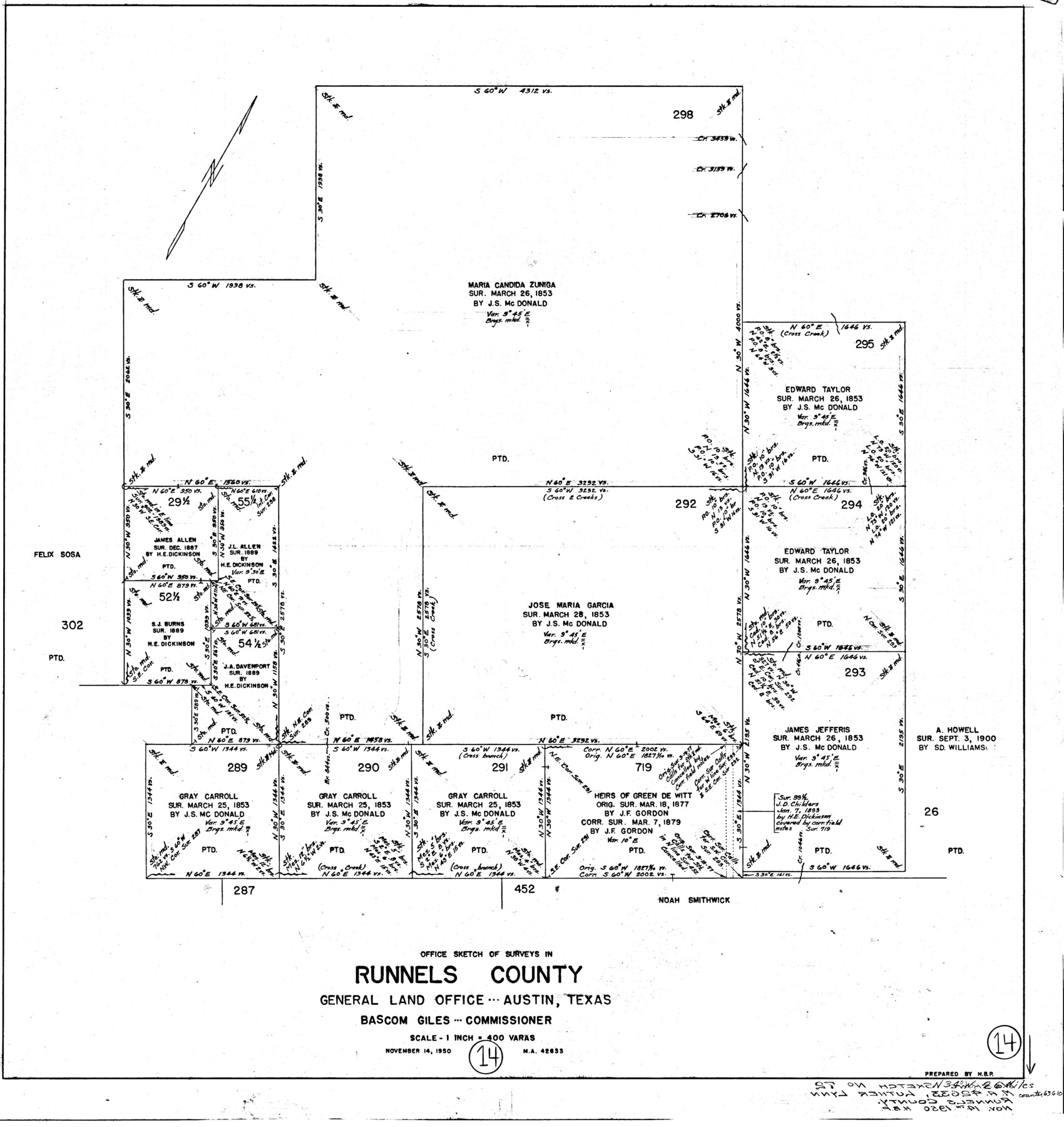
Runnels County Working Sketch 14
-
Map/Doc
63610
-
Collection
General Map Collection
-
Object Dates
11/14/1950 (Creation Date)
-
Counties
Runnels
-
Subjects
Surveying Working Sketch
-
Height x Width
28.4 x 26.8 inches
72.1 x 68.1 cm
-
Scale
1" = 400 varas
Part of: General Map Collection
Pecos County Sketch File 39

Print $20.00
- Digital $50.00
Pecos County Sketch File 39
1898
Size 17.5 x 16.5 inches
Map/Doc 12177
Rusk County Sketch File 35

Print $6.00
Rusk County Sketch File 35
1950
Size 11.3 x 8.8 inches
Map/Doc 35573
Morris County Rolled Sketch 2A

Print $20.00
- Digital $50.00
Morris County Rolled Sketch 2A
Size 24.0 x 18.7 inches
Map/Doc 10272
Coke County Working Sketch 19

Print $20.00
- Digital $50.00
Coke County Working Sketch 19
1948
Size 22.2 x 29.0 inches
Map/Doc 68056
El Paso County Working Sketch 35

Print $20.00
- Digital $50.00
El Paso County Working Sketch 35
1977
Size 19.8 x 30.3 inches
Map/Doc 69057
Dimmit County Working Sketch 42

Print $20.00
- Digital $50.00
Dimmit County Working Sketch 42
1977
Size 33.5 x 39.6 inches
Map/Doc 68703
Right of Way and Track Map, the Missouri, Kansas and Texas Ry. of Texas operated by the Missouri, Kansas and Texas Ry. of Texas, San Antonio Division

Print $40.00
- Digital $50.00
Right of Way and Track Map, the Missouri, Kansas and Texas Ry. of Texas operated by the Missouri, Kansas and Texas Ry. of Texas, San Antonio Division
1918
Size 25.6 x 57.8 inches
Map/Doc 64582
Brooks County Sketch File 3

Print $40.00
- Digital $50.00
Brooks County Sketch File 3
Size 21.5 x 19.0 inches
Map/Doc 11016
Dawson County Sketch File 9

Print $4.00
- Digital $50.00
Dawson County Sketch File 9
1925
Size 11.3 x 8.7 inches
Map/Doc 20542
Hartley County

Print $20.00
- Digital $50.00
Hartley County
1925
Size 34.2 x 41.5 inches
Map/Doc 77306
Flight Mission No. DCL-7C, Frame 26, Kenedy County

Print $20.00
- Digital $50.00
Flight Mission No. DCL-7C, Frame 26, Kenedy County
1943
Size 15.3 x 15.5 inches
Map/Doc 86018
Kendall County Rolled Sketch 9

Print $20.00
- Digital $50.00
Kendall County Rolled Sketch 9
1990
Size 32.8 x 24.3 inches
Map/Doc 95298
You may also like
Randall County Rolled Sketch 10

Print $20.00
- Digital $50.00
Randall County Rolled Sketch 10
Size 26.9 x 22.6 inches
Map/Doc 7431
Pecos County Rolled Sketch 179

Print $20.00
- Digital $50.00
Pecos County Rolled Sketch 179
1980
Size 28.0 x 28.2 inches
Map/Doc 7299
General Highway Map, Falls County, Texas

Print $20.00
General Highway Map, Falls County, Texas
1940
Size 18.5 x 24.7 inches
Map/Doc 79088
Cottle County Sketch File 6

Print $20.00
- Digital $50.00
Cottle County Sketch File 6
1883
Size 20.3 x 29.8 inches
Map/Doc 11190
Map of a part of Laguna Madre showing subdivision for mineral development

Print $20.00
- Digital $50.00
Map of a part of Laguna Madre showing subdivision for mineral development
1950
Size 40.7 x 26.9 inches
Map/Doc 2917
Dimmit County Sketch File 62

Print $8.00
- Digital $50.00
Dimmit County Sketch File 62
2012
Size 11.0 x 8.5 inches
Map/Doc 93631
Travis County Working Sketch 43

Print $20.00
- Digital $50.00
Travis County Working Sketch 43
1974
Size 24.1 x 24.6 inches
Map/Doc 69427
General Highway Map. Detail of Cities and Towns in Travis County, Texas. City Map, Austin and vicinity, Travis County, Texas

Print $20.00
General Highway Map. Detail of Cities and Towns in Travis County, Texas. City Map, Austin and vicinity, Travis County, Texas
1961
Size 18.2 x 25.0 inches
Map/Doc 79685
Grayson County Working Sketch 20

Print $20.00
- Digital $50.00
Grayson County Working Sketch 20
1956
Size 25.4 x 31.3 inches
Map/Doc 63259
Taylor County Sketch File 18

Print $6.00
- Digital $50.00
Taylor County Sketch File 18
Size 11.6 x 7.3 inches
Map/Doc 37813
Nueces County Sketch File 30

Print $3.00
- Digital $50.00
Nueces County Sketch File 30
1907
Size 11.4 x 11.9 inches
Map/Doc 32600
General Highway Map, Lampasas County, Texas

Print $20.00
General Highway Map, Lampasas County, Texas
1961
Size 18.2 x 24.7 inches
Map/Doc 79563