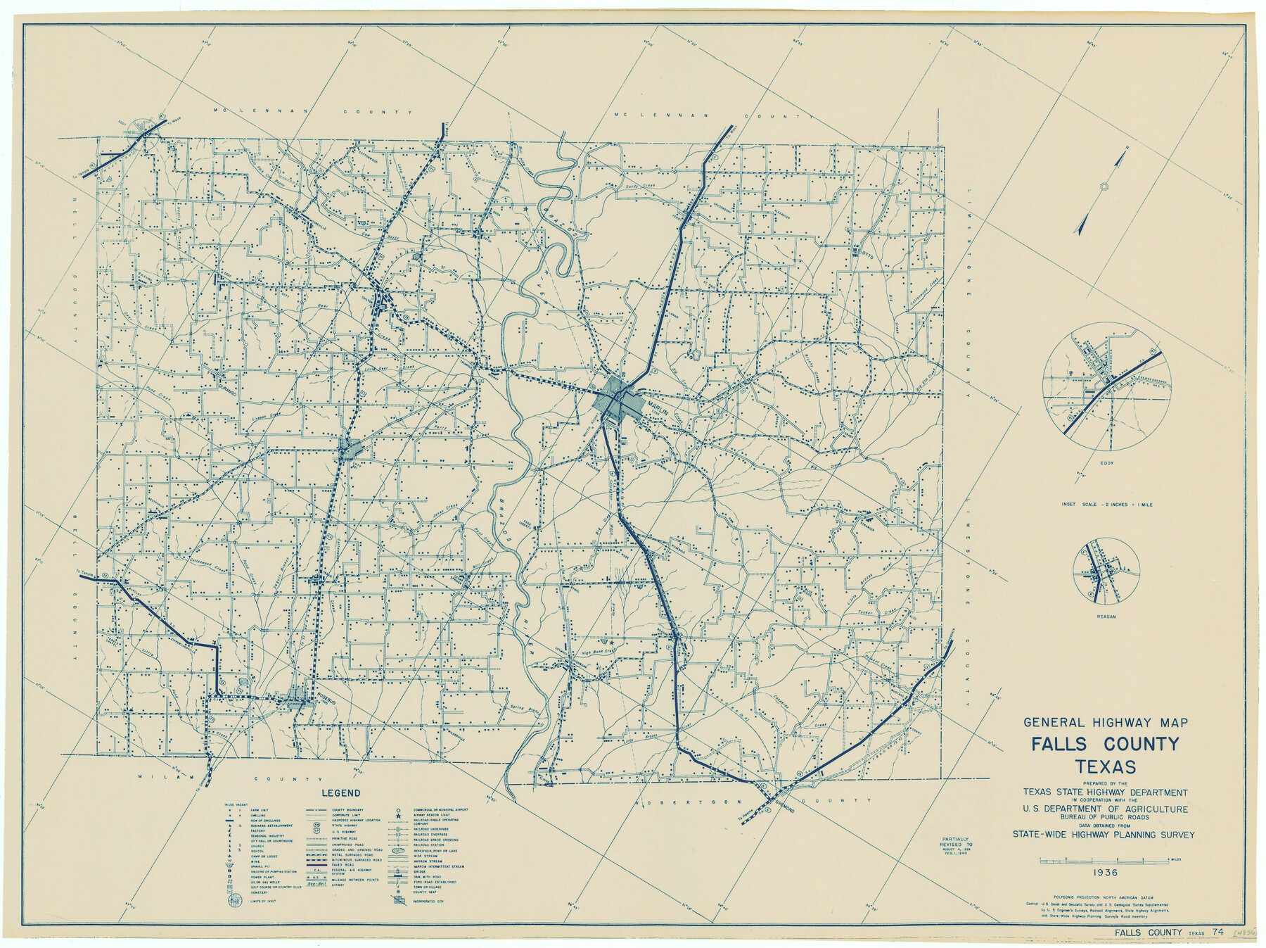
General Highway Map, Falls County, Texas
-
Map/Doc
79088
-
Collection
Texas State Library and Archives
-
Object Dates
1940 (Creation Date)
-
People and Organizations
Texas State Highway Department (Publisher)
-
Counties
Falls
-
Subjects
County
-
Height x Width
18.5 x 24.7 inches
47.0 x 62.7 cm
-
Comments
Prints available courtesy of the Texas State Library and Archives.
More info can be found here: TSLAC Map 04857
Part of: Texas State Library and Archives
Karte des Staates, Texas

Print $20.00
Karte des Staates, Texas
1851
Size 27.2 x 30.1 inches
Map/Doc 76262
General Highway Map, Refugio County, Texas

Print $20.00
General Highway Map, Refugio County, Texas
1961
Size 18.1 x 24.7 inches
Map/Doc 79639
Rand McNally Standard Map of Texas

Print $20.00
Rand McNally Standard Map of Texas
1923
Size 27.6 x 40.3 inches
Map/Doc 76261
Map of Texas, compiled from surveys on record in the General Land Office of the Republic

Print $20.00
Map of Texas, compiled from surveys on record in the General Land Office of the Republic
1847
Size 32.2 x 25.0 inches
Map/Doc 79325
General Highway Map, Dallas County, Rockwall County, Texas

Print $20.00
General Highway Map, Dallas County, Rockwall County, Texas
1961
Size 18.4 x 24.5 inches
Map/Doc 79430
General Highway Map, Sabine County, Texas

Print $20.00
General Highway Map, Sabine County, Texas
1961
Size 24.6 x 18.1 inches
Map/Doc 79644
General Highway Map, Ward County, Texas

Print $20.00
General Highway Map, Ward County, Texas
1940
Size 18.5 x 25.1 inches
Map/Doc 79271
General Highway Map, San Saba County, Texas

Print $20.00
General Highway Map, San Saba County, Texas
1940
Size 18.3 x 24.8 inches
Map/Doc 79238
Reconnaissance of Aransas Pass, Texas

Print $20.00
Reconnaissance of Aransas Pass, Texas
1853
Size 14.9 x 12.4 inches
Map/Doc 76250
General Highway Map, Floyd County, Texas

Print $20.00
General Highway Map, Floyd County, Texas
1940
Size 25.1 x 18.7 inches
Map/Doc 79091
[General Highway Map of] Bexar County, Sheet 1 of 2
![76288, [General Highway Map of] Bexar County, Sheet 1 of 2, Texas State Library and Archives](https://historictexasmaps.com/wmedia_w700/maps/76288.tif.jpg)
Print $20.00
[General Highway Map of] Bexar County, Sheet 1 of 2
1940
Size 18.5 x 25.1 inches
Map/Doc 76288
General Highway Map. Detail of Cities and Towns in Potter County, Texas [Amarillo and vicinity]
![79221, General Highway Map. Detail of Cities and Towns in Potter County, Texas [Amarillo and vicinity], Texas State Library and Archives](https://historictexasmaps.com/wmedia_w700/maps/79221.tif.jpg)
Print $20.00
General Highway Map. Detail of Cities and Towns in Potter County, Texas [Amarillo and vicinity]
1940
Size 24.6 x 18.2 inches
Map/Doc 79221
You may also like
Ector County Working Sketch 25

Print $20.00
- Digital $50.00
Ector County Working Sketch 25
1961
Size 29.6 x 34.2 inches
Map/Doc 68868
Northern Part of Laguna Madre

Print $20.00
- Digital $50.00
Northern Part of Laguna Madre
1959
Size 44.5 x 35.1 inches
Map/Doc 73525
Flight Mission No. CLL-1N, Frame 110, Willacy County

Print $20.00
- Digital $50.00
Flight Mission No. CLL-1N, Frame 110, Willacy County
1954
Size 18.5 x 22.1 inches
Map/Doc 87044
Railroad Track Map, H&TCRRCo., Falls County, Texas

Print $4.00
- Digital $50.00
Railroad Track Map, H&TCRRCo., Falls County, Texas
1918
Size 11.8 x 18.6 inches
Map/Doc 62836
Tarrant County Working Sketch 10

Print $40.00
- Digital $50.00
Tarrant County Working Sketch 10
1986
Size 29.4 x 58.0 inches
Map/Doc 62427
Flight Mission No. DIX-10P, Frame 149, Aransas County

Print $20.00
- Digital $50.00
Flight Mission No. DIX-10P, Frame 149, Aransas County
1956
Size 18.6 x 22.3 inches
Map/Doc 83951
Laneer vs. Bivins, Potter County, Texas

Print $20.00
- Digital $50.00
Laneer vs. Bivins, Potter County, Texas
Size 21.4 x 18.8 inches
Map/Doc 93102
Presidio County Rolled Sketch 106

Print $20.00
- Digital $50.00
Presidio County Rolled Sketch 106
1955
Size 23.0 x 36.4 inches
Map/Doc 7387
Map of Bexar County

Print $40.00
- Digital $50.00
Map of Bexar County
1887
Size 46.1 x 48.6 inches
Map/Doc 16942
Flight Mission No. BQR-9K, Frame 42, Brazoria County

Print $20.00
- Digital $50.00
Flight Mission No. BQR-9K, Frame 42, Brazoria County
1952
Size 18.6 x 22.2 inches
Map/Doc 84046
Randall County Boundary File 3

Print $8.00
- Digital $50.00
Randall County Boundary File 3
Size 14.3 x 8.8 inches
Map/Doc 58125
L'Amerique Meridionale, et Septentrionale Dressee selon les derniers Relations et suivant les Nouvelles Decouvertes

Print $20.00
- Digital $50.00
L'Amerique Meridionale, et Septentrionale Dressee selon les derniers Relations et suivant les Nouvelles Decouvertes
1726
Size 18.9 x 24.1 inches
Map/Doc 95134