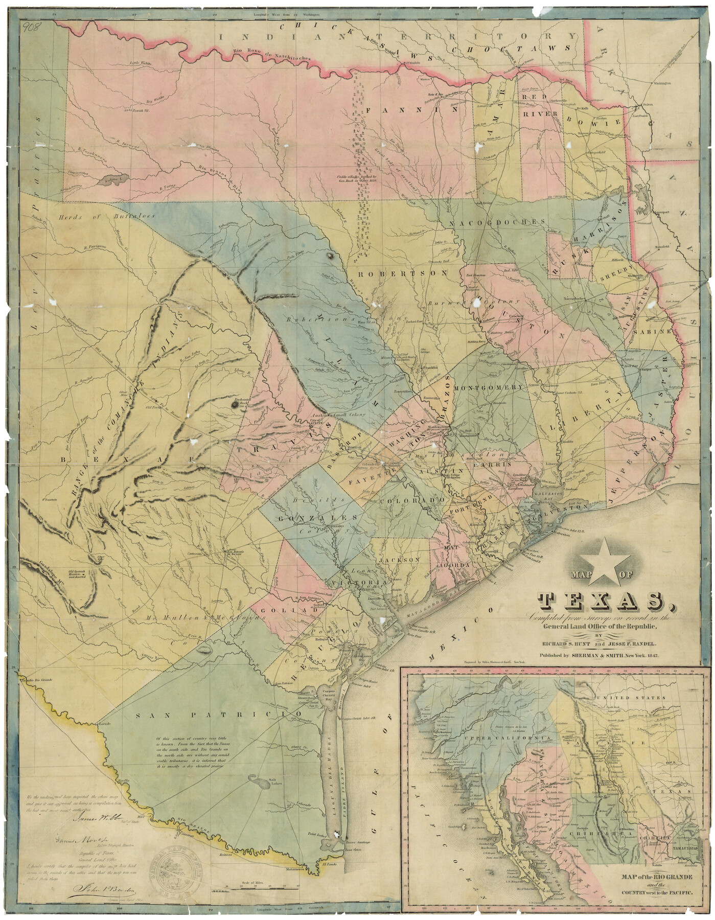
Map of Texas, compiled from surveys on record in the General Land Office of the Republic
-
Map/Doc
79325
-
Collection
Texas State Library and Archives
-
Object Dates
1847 (Creation Date)
-
People and Organizations
Sherman and Smith (Publisher)
Stiles, Sherman and Smith (Printer)
Jesse F. Randel (Compiler)
Richard S. Hunt (Draftsman)
Richard S. Hunt (Compiler)
Jesse F. Randel (Draftsman)
-
Subjects
State of Texas
-
Height x Width
32.2 x 25.0 inches
81.8 x 63.5 cm
-
Comments
Prints available courtesy of the Texas State Library and Archives.
More info can be found here: TSLAC Map 00908
Part of: Texas State Library and Archives
General Highway Map, Wichita County, Texas

Print $20.00
General Highway Map, Wichita County, Texas
1940
Size 18.1 x 24.8 inches
Map/Doc 79277
General Highway Map, Victoria County, Texas

Print $20.00
General Highway Map, Victoria County, Texas
1961
Size 25.0 x 18.3 inches
Map/Doc 79697
General Highway Map, Crane County, Texas

Print $20.00
General Highway Map, Crane County, Texas
1961
Size 24.8 x 18.2 inches
Map/Doc 79424
General Highway Map, Crane County, Texas

Print $20.00
General Highway Map, Crane County, Texas
1940
Size 25.2 x 18.3 inches
Map/Doc 79061
General Highway Map, Garza County, Texas

Print $20.00
General Highway Map, Garza County, Texas
1961
Size 18.2 x 24.6 inches
Map/Doc 79478
General Highway Map, Reeves County, Texas

Print $20.00
General Highway Map, Reeves County, Texas
1961
Size 24.6 x 18.2 inches
Map/Doc 79638
General Highway Map, Winkler County, Texas

Print $20.00
General Highway Map, Winkler County, Texas
1940
Size 18.4 x 24.7 inches
Map/Doc 79283
General Highway Map, Nolan County, Texas

Print $20.00
General Highway Map, Nolan County, Texas
1961
Size 19.3 x 25.0 inches
Map/Doc 79614
Map of the City of Galveston, situated on the East End of Galveston Island, Texas

Print $20.00
Map of the City of Galveston, situated on the East End of Galveston Island, Texas
1869
Size 33.3 x 46.6 inches
Map/Doc 76186
General Highway Map, Tom Green County, Texas

Print $20.00
General Highway Map, Tom Green County, Texas
1961
Size 18.4 x 25.0 inches
Map/Doc 79678
General Highway Map. Detail of Cities and Towns in Lubbock County, Texas [Lubbock and vicinity]
![79579, General Highway Map. Detail of Cities and Towns in Lubbock County, Texas [Lubbock and vicinity], Texas State Library and Archives](https://historictexasmaps.com/wmedia_w700/maps/79579.tif.jpg)
Print $20.00
General Highway Map. Detail of Cities and Towns in Lubbock County, Texas [Lubbock and vicinity]
1961
Size 18.2 x 24.7 inches
Map/Doc 79579
General Highway Map, Grayson County, Texas

Print $20.00
General Highway Map, Grayson County, Texas
1961
Size 24.6 x 18.1 inches
Map/Doc 79485
You may also like
Flight Mission No. BRA-16M, Frame 51, Jefferson County

Print $20.00
- Digital $50.00
Flight Mission No. BRA-16M, Frame 51, Jefferson County
1953
Size 18.6 x 22.6 inches
Map/Doc 85668
Colorado County Rolled Sketch 3

Print $20.00
- Digital $50.00
Colorado County Rolled Sketch 3
1943
Size 42.4 x 38.7 inches
Map/Doc 8641
Flight Mission No. CRC-2R, Frame 64, Chambers County

Print $20.00
- Digital $50.00
Flight Mission No. CRC-2R, Frame 64, Chambers County
1956
Size 18.7 x 22.5 inches
Map/Doc 84735

Alexander's Subdivision Tract 2, League 64 Midland County School Land, Cochran County, Texas

Print $20.00
- Digital $50.00
Alexander's Subdivision Tract 2, League 64 Midland County School Land, Cochran County, Texas
1937
Size 19.1 x 22.7 inches
Map/Doc 92518
Kendall County Sketch File 13

Print $4.00
- Digital $50.00
Kendall County Sketch File 13
1860
Size 10.1 x 8.0 inches
Map/Doc 28699
Flight Mission No. DQN-5K, Frame 50, Calhoun County

Print $20.00
- Digital $50.00
Flight Mission No. DQN-5K, Frame 50, Calhoun County
1953
Size 18.5 x 22.3 inches
Map/Doc 84395
Travis County State Real Property Sketch 4

Print $20.00
- Digital $50.00
Travis County State Real Property Sketch 4
1987
Size 25.7 x 30.7 inches
Map/Doc 61695
Stephens County Working Sketch 5

Print $20.00
- Digital $50.00
Stephens County Working Sketch 5
1919
Size 24.8 x 25.3 inches
Map/Doc 63948
Morris County Rolled Sketch 2A

Print $20.00
- Digital $50.00
Morris County Rolled Sketch 2A
Size 24.0 x 18.7 inches
Map/Doc 10234
[Cotton Belt, St. Louis Southwestern Railway of Texas, Alignment through Smith County]
![64381, [Cotton Belt, St. Louis Southwestern Railway of Texas, Alignment through Smith County], General Map Collection](https://historictexasmaps.com/wmedia_w700/maps/64381.tif.jpg)
Print $20.00
- Digital $50.00
[Cotton Belt, St. Louis Southwestern Railway of Texas, Alignment through Smith County]
1903
Size 21.3 x 29.4 inches
Map/Doc 64381
South Part Presidio County

Print $20.00
- Digital $50.00
South Part Presidio County
1975
Size 35.0 x 40.3 inches
Map/Doc 95617