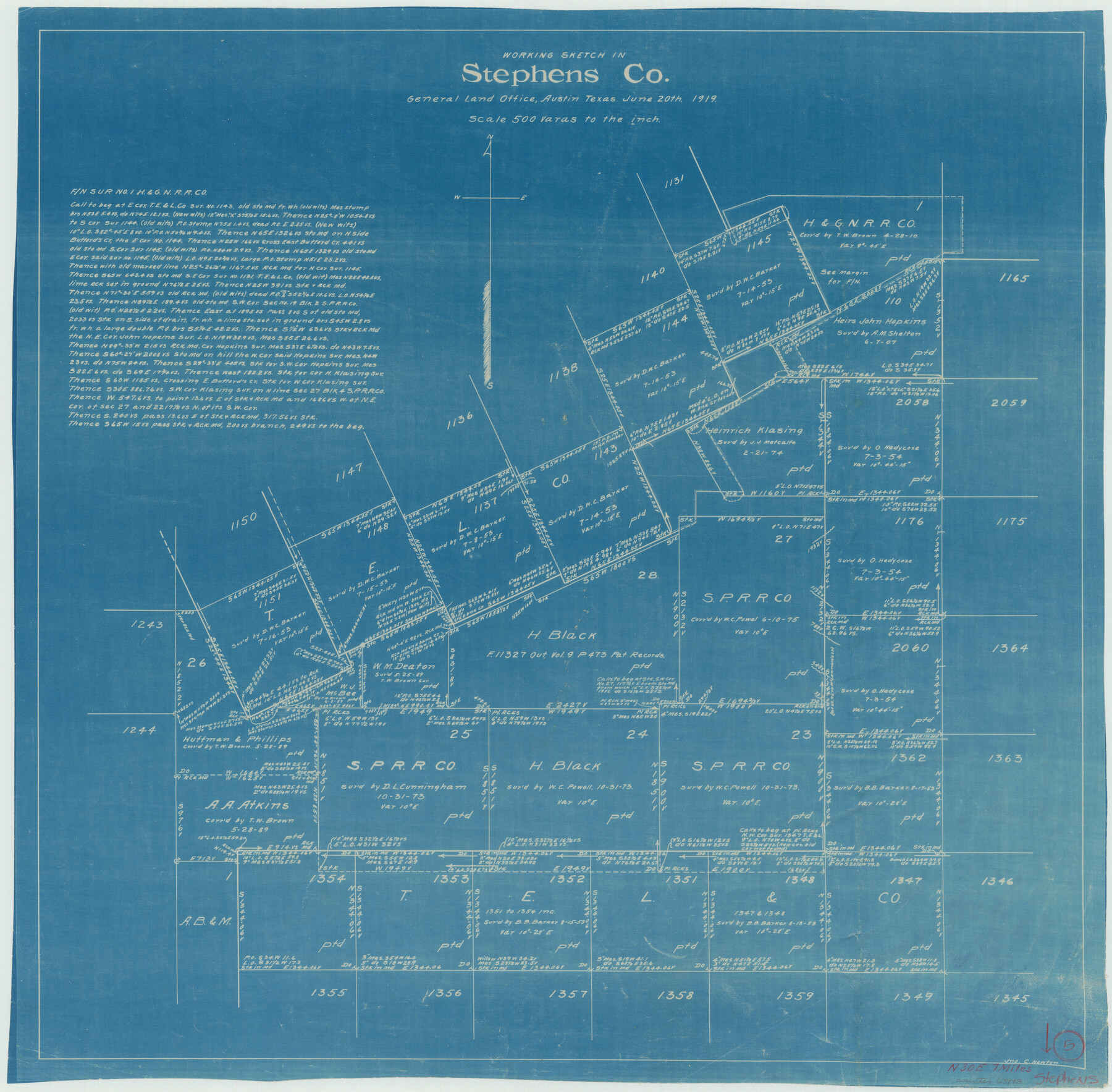
Stephens County Working Sketch 5
-
Map/Doc
63948
-
Collection
General Map Collection
-
Object Dates
6/20/1919 (Creation Date)
-
People and Organizations
John C. Newton (Draftsman)
-
Counties
Stephens
-
Subjects
Surveying Working Sketch
-
Height x Width
24.8 x 25.3 inches
63.0 x 64.3 cm
-
Scale
1" = 500 varas
Part of: General Map Collection
[Jack District]
![1992, [Jack District], General Map Collection](https://historictexasmaps.com/wmedia_w700/maps/1992.tif.jpg)
Print $40.00
- Digital $50.00
[Jack District]
1880
Size 52.7 x 43.4 inches
Map/Doc 1992
Willacy County Boundary File 1

Print $23.00
- Digital $50.00
Willacy County Boundary File 1
Size 11.3 x 8.8 inches
Map/Doc 59956
Ward County Rolled Sketch 24F

Print $40.00
- Digital $50.00
Ward County Rolled Sketch 24F
1967
Size 43.0 x 72.4 inches
Map/Doc 10117
Limestone County Sketch File 14

Print $4.00
- Digital $50.00
Limestone County Sketch File 14
1883
Size 10.7 x 8.2 inches
Map/Doc 30179
Mason County Boundary File 63

Print $10.00
- Digital $50.00
Mason County Boundary File 63
Size 9.4 x 5.9 inches
Map/Doc 56879
[Maps of surveys in Reeves & Culberson Cos]
![61140, [Maps of surveys in Reeves & Culberson Cos], General Map Collection](https://historictexasmaps.com/wmedia_w700/maps/61140.tif.jpg)
Print $20.00
- Digital $50.00
[Maps of surveys in Reeves & Culberson Cos]
1937
Size 30.6 x 24.9 inches
Map/Doc 61140
Baffin Bay, Texas from Penescal Triangulation Station to Bovido Triangulation Station

Print $40.00
- Digital $50.00
Baffin Bay, Texas from Penescal Triangulation Station to Bovido Triangulation Station
1881
Size 32.6 x 54.2 inches
Map/Doc 73484

General Homes Free Houston Area Map

General Homes Free Houston Area Map
Size 27.1 x 42.5 inches
Map/Doc 94393
Aransas County Rolled Sketch 2

Print $40.00
- Digital $50.00
Aransas County Rolled Sketch 2
1950
Size 27.9 x 51.4 inches
Map/Doc 73613
Flight Mission No. DIX-8P, Frame 64, Aransas County

Print $20.00
- Digital $50.00
Flight Mission No. DIX-8P, Frame 64, Aransas County
1956
Size 18.7 x 22.4 inches
Map/Doc 83895
Cass County Sketch File 24

Print $16.00
- Digital $50.00
Cass County Sketch File 24
1936
Size 13.9 x 8.7 inches
Map/Doc 17436
You may also like
McLennan County Boundary File 4

Print $12.00
- Digital $50.00
McLennan County Boundary File 4
Size 8.8 x 7.5 inches
Map/Doc 56973
![92632, [League 280], Twichell Survey Records](https://historictexasmaps.com/wmedia_w700/maps/92632-1.tif.jpg)
Map of Williamson County

Print $20.00
- Digital $50.00
Map of Williamson County
1863
Size 22.7 x 29.7 inches
Map/Doc 4150
Webb County Sketch File 13-2

Print $20.00
- Digital $50.00
Webb County Sketch File 13-2
1936
Size 16.4 x 20.3 inches
Map/Doc 12632
Rains County Boundary File 2

Print $4.00
- Digital $50.00
Rains County Boundary File 2
Size 8.2 x 5.8 inches
Map/Doc 58092
Topographic Map, Reynard Sheet, Trinity River; Houston and Leon Counties

Print $20.00
- Digital $50.00
Topographic Map, Reynard Sheet, Trinity River; Houston and Leon Counties
1925
Size 45.6 x 41.4 inches
Map/Doc 2469
A Correct Map of the Seat of War in Mexico Being a Copy of Genl Arista's Map, taken at Resaca de la Palma, with additions and Corrections

Print $20.00
- Digital $50.00
A Correct Map of the Seat of War in Mexico Being a Copy of Genl Arista's Map, taken at Resaca de la Palma, with additions and Corrections
1847
Size 30.7 x 22.5 inches
Map/Doc 93962
Map of Texas in 1830 Showing Spanish Colonies

Print $20.00
- Digital $50.00
Map of Texas in 1830 Showing Spanish Colonies
Size 41.1 x 42.0 inches
Map/Doc 73588
Menard County Sketch File 12

Print $12.00
- Digital $50.00
Menard County Sketch File 12
1892
Size 11.1 x 8.2 inches
Map/Doc 31500
Nolan County Sketch File 18

Print $8.00
- Digital $50.00
Nolan County Sketch File 18
Size 14.3 x 8.9 inches
Map/Doc 32489
San Patricio County Rolled Sketch 45

Print $20.00
- Digital $50.00
San Patricio County Rolled Sketch 45
1979
Size 24.0 x 33.5 inches
Map/Doc 7729
General Highway Map, Sabine County, Texas

Print $20.00
General Highway Map, Sabine County, Texas
1940
Size 24.9 x 18.4 inches
Map/Doc 79234