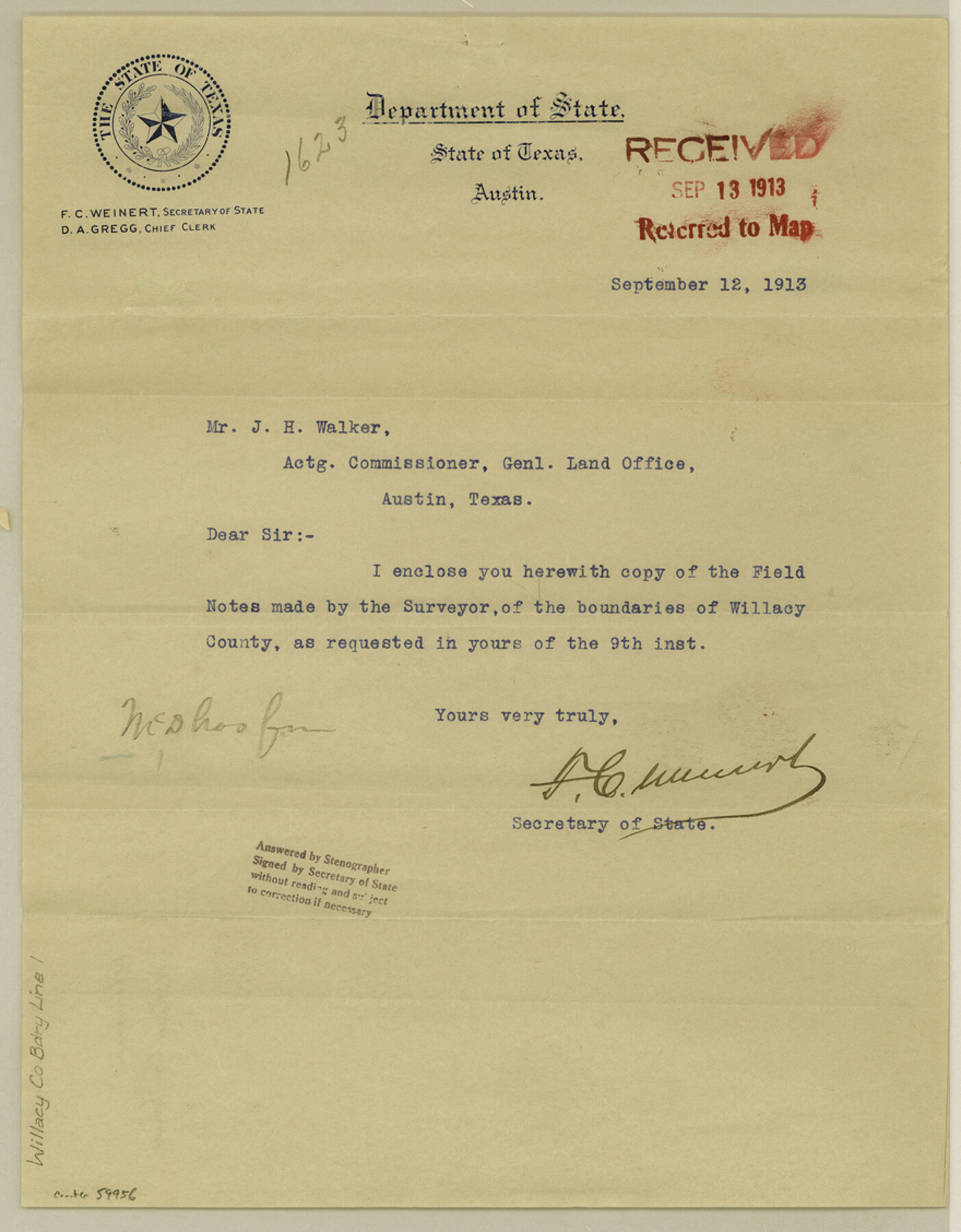
Willacy County Boundary File 1
County Boundary of Willacy County
-
Map/Doc
59956
-
Collection
General Map Collection
-
Counties
Willacy
-
Subjects
County Boundaries
-
Height x Width
11.3 x 8.8 inches
28.7 x 22.4 cm
Part of: General Map Collection
Kendall County Sketch File 17

Print $4.00
- Digital $50.00
Kendall County Sketch File 17
1878
Size 9.1 x 7.6 inches
Map/Doc 28709
Walker County Working Sketch 11

Print $20.00
- Digital $50.00
Walker County Working Sketch 11
1935
Size 28.2 x 38.8 inches
Map/Doc 72291
Travis County Rolled Sketch 58

Print $20.00
- Digital $50.00
Travis County Rolled Sketch 58
Size 37.4 x 25.5 inches
Map/Doc 8049
Duval County Rolled Sketch 37

Print $20.00
- Digital $50.00
Duval County Rolled Sketch 37
1952
Size 29.2 x 24.6 inches
Map/Doc 5753
Land of the Maya, a Traveler's Map

Land of the Maya, a Traveler's Map
Size 27.2 x 20.5 inches
Map/Doc 95933
Aransas County Boundary File 1

Print $14.00
- Digital $50.00
Aransas County Boundary File 1
Size 14.2 x 8.6 inches
Map/Doc 49774
La Salle County Sketch File 34

Print $6.00
- Digital $50.00
La Salle County Sketch File 34
Size 15.8 x 9.5 inches
Map/Doc 29585
Grayson County Working Sketch 14

Print $20.00
- Digital $50.00
Grayson County Working Sketch 14
1952
Size 23.9 x 23.3 inches
Map/Doc 63253
Trinity River, Levee Improvement Districts Widths of Floodways

Print $6.00
- Digital $50.00
Trinity River, Levee Improvement Districts Widths of Floodways
1920
Size 33.9 x 23.0 inches
Map/Doc 65249

Flight Mission No. DAH-9M, Frame 205, Orange County

Print $20.00
- Digital $50.00
Flight Mission No. DAH-9M, Frame 205, Orange County
1953
Size 18.7 x 22.6 inches
Map/Doc 86873
[Right of Way & Track Map, The Texas & Pacific Ry. Co. Main Line]
![64684, [Right of Way & Track Map, The Texas & Pacific Ry. Co. Main Line], General Map Collection](https://historictexasmaps.com/wmedia_w700/maps/64684.tif.jpg)
Print $20.00
- Digital $50.00
[Right of Way & Track Map, The Texas & Pacific Ry. Co. Main Line]
Size 11.0 x 19.0 inches
Map/Doc 64684
You may also like
Sketch B Showing the progress of Section No. 2

Print $20.00
- Digital $50.00
Sketch B Showing the progress of Section No. 2
1844
Size 25.3 x 27.7 inches
Map/Doc 97204
Trinity River, Levee Improvements, District Widths of Floodways

Print $20.00
- Digital $50.00
Trinity River, Levee Improvements, District Widths of Floodways
1920
Size 25.0 x 18.6 inches
Map/Doc 65252
Flight Mission No. BQY-4M, Frame 120, Harris County

Print $20.00
- Digital $50.00
Flight Mission No. BQY-4M, Frame 120, Harris County
1953
Size 18.5 x 22.3 inches
Map/Doc 85288
Brewster County Working Sketch 84

Print $20.00
- Digital $50.00
Brewster County Working Sketch 84
1973
Size 44.9 x 39.4 inches
Map/Doc 67684
Map of the chief part of the Southern States and part of the Western engraved to illustrate Mitchell's school and family geography

Print $20.00
- Digital $50.00
Map of the chief part of the Southern States and part of the Western engraved to illustrate Mitchell's school and family geography
1839
Size 11.8 x 17.5 inches
Map/Doc 93497
[PSL Blks. A55, A56, 77, B1, B2, B6 and and B10]
![89821, [PSL Blks. A55, A56, 77, B1, B2, B6 and and B10], Twichell Survey Records](https://historictexasmaps.com/wmedia_w700/maps/89821-1.tif.jpg)
Print $40.00
- Digital $50.00
[PSL Blks. A55, A56, 77, B1, B2, B6 and and B10]
Size 24.0 x 69.3 inches
Map/Doc 89821
Plat of Proposed County

Print $20.00
- Digital $50.00
Plat of Proposed County
1909
Size 23.9 x 30.8 inches
Map/Doc 1712
Dimmit County Working Sketch 35

Print $20.00
- Digital $50.00
Dimmit County Working Sketch 35
1961
Size 22.4 x 24.4 inches
Map/Doc 68696
The Chief Justice County of Bexar. Lands in Conflict with Milam County

Print $20.00
The Chief Justice County of Bexar. Lands in Conflict with Milam County
2020
Size 14.6 x 21.6 inches
Map/Doc 96039
Grayson County Working Sketch 15

Print $20.00
- Digital $50.00
Grayson County Working Sketch 15
1953
Size 24.8 x 20.6 inches
Map/Doc 63254
[Leagues 152 and 153]
![90287, [Leagues 152 and 153], Twichell Survey Records](https://historictexasmaps.com/wmedia_w700/maps/90287-1.tif.jpg)
Print $20.00
- Digital $50.00
[Leagues 152 and 153]
Size 16.4 x 22.4 inches
Map/Doc 90287
General Highway Map, Mason County, Texas

Print $20.00
General Highway Map, Mason County, Texas
1961
Size 18.3 x 24.8 inches
Map/Doc 79584