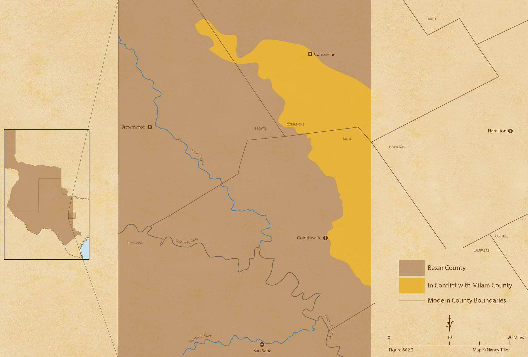
The Chief Justice County of Bexar. Lands in Conflict with Milam County
Figure No. 602.2 from 'A Boundary Atlas of Texas, 1821-1845' by Jim Tiller
-
Map/Doc
96039
-
Collection
Nancy and Jim Tiller Digital Collection
-
Object Dates
2020/1/1 (Creation Date)
-
People and Organizations
Jim Tiller (Author)
Nancy Tiller (Cartographer)
Gang Gong (GIS Professional)
-
Subjects
Atlas Republic of Texas Texas Boundaries
-
Height x Width
14.6 x 21.6 inches
37.1 x 54.9 cm
-
Medium
digital image
-
Comments
To purchase a digital PDF copy of "A Boundary Atlas of Texas, 1821-1845" see 96437.
Part of: Nancy and Jim Tiller Digital Collection
The Republic County of Sabine. Boundaries Defined, December14, 1837

Print $20.00
The Republic County of Sabine. Boundaries Defined, December14, 1837
2020
Size 17.6 x 21.7 inches
Map/Doc 96269
From Citizens of Washington County to Establish a New Eastern Boundary, November 30, 1837

Print $20.00
From Citizens of Washington County to Establish a New Eastern Boundary, November 30, 1837
2020
Size 14.2 x 21.7 inches
Map/Doc 96375
The Republic County of Shelby. December 29, 1845

Print $20.00
The Republic County of Shelby. December 29, 1845
2020
Size 20.0 x 21.7 inches
Map/Doc 96288
The Republic County of Victoria. Spring 1842

Print $20.00
The Republic County of Victoria. Spring 1842
2020
Size 24.3 x 21.7 inches
Map/Doc 96300
The Mexican Department of Bexar. March 18, 1834

Print $20.00
The Mexican Department of Bexar. March 18, 1834
2020
Size 16.0 x 21.7 inches
Map/Doc 95970
The Chief Justice County of Goliad. Proposed, No Date

Print $20.00
The Chief Justice County of Goliad. Proposed, No Date
2020
Size 14.7 x 21.7 inches
Map/Doc 96046
The Judicial District/County of Menard. Created, January 22, 1841

Print $20.00
The Judicial District/County of Menard. Created, January 22, 1841
2020
Size 22.4 x 21.7 inches
Map/Doc 96335
From Citizens of Liberty County for the Creation of a New County (Unnamed), September 7, 1840

Print $20.00
From Citizens of Liberty County for the Creation of a New County (Unnamed), September 7, 1840
2020
Size 25.0 x 21.7 inches
Map/Doc 96390
The Republic County of Shelby. January 28, 1839

Print $20.00
The Republic County of Shelby. January 28, 1839
2020
Size 21.1 x 21.7 inches
Map/Doc 96281
The Chief Justice County of Gonzales. Lands in Conflict with Victoria County

Print $20.00
The Chief Justice County of Gonzales. Lands in Conflict with Victoria County
2020
Size 22.3 x 21.7 inches
Map/Doc 96048
From Citizens of Red River County for the Creation of a New County to be Called Aurora, December 3, 1840

Print $20.00
From Citizens of Red River County for the Creation of a New County to be Called Aurora, December 3, 1840
2020
Size 19.8 x 21.7 inches
Map/Doc 96391
From Citizens of Bastrop County for the Creation of a New County (Unnamed), October 1838

Print $20.00
From Citizens of Bastrop County for the Creation of a New County (Unnamed), October 1838
2020
Size 21.6 x 21.7 inches
Map/Doc 96384
You may also like
Presidio County Working Sketch 102

Print $20.00
- Digital $50.00
Presidio County Working Sketch 102
1980
Size 30.9 x 28.9 inches
Map/Doc 71779
Young County Working Sketch 8

Print $20.00
- Digital $50.00
Young County Working Sketch 8
1920
Size 17.3 x 12.6 inches
Map/Doc 62031
Duval County Working Sketch 16

Print $20.00
- Digital $50.00
Duval County Working Sketch 16
1939
Size 14.6 x 25.3 inches
Map/Doc 68729
Yellow Fever Deaths in the United States

Yellow Fever Deaths in the United States
2022
Size 8.5 x 11.0 inches
Map/Doc 97093
Loving County Working Sketch 2

Print $20.00
- Digital $50.00
Loving County Working Sketch 2
1937
Size 33.9 x 42.5 inches
Map/Doc 70634
Llano County Working Sketch 4

Print $40.00
- Digital $50.00
Llano County Working Sketch 4
1954
Size 33.4 x 54.0 inches
Map/Doc 70622

Kinney County

Print $40.00
- Digital $50.00
Kinney County
1909
Size 49.8 x 44.2 inches
Map/Doc 66893

Flight Mission No. CUG-2P, Frame 24, Kleberg County

Print $20.00
- Digital $50.00
Flight Mission No. CUG-2P, Frame 24, Kleberg County
1956
Size 18.4 x 22.3 inches
Map/Doc 86188
Old Miscellaneous File 21

Print $16.00
- Digital $50.00
Old Miscellaneous File 21
Size 14.3 x 8.7 inches
Map/Doc 75583
Morris County Rolled Sketch 2A

Print $20.00
- Digital $50.00
Morris County Rolled Sketch 2A
Size 36.7 x 25.1 inches
Map/Doc 10259