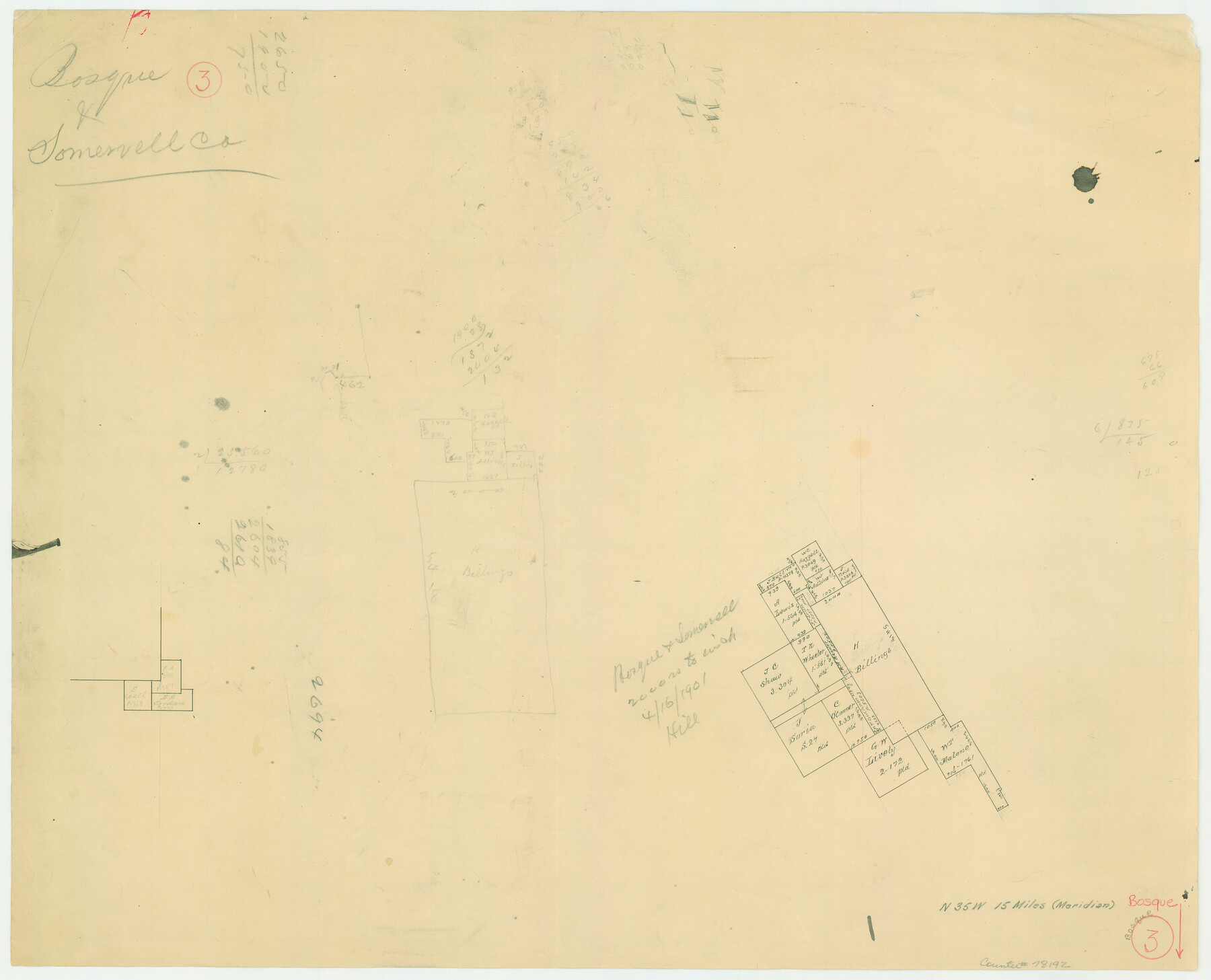
Bosque County Working Sketch 3
-
Map/Doc
78192
-
Collection
General Map Collection
-
Object Dates
4/16/1901 (Creation Date)
-
Counties
Bosque Somervell
-
Subjects
Surveying Working Sketch
-
Height x Width
16.5 x 20.4 inches
41.9 x 51.8 cm
-
Scale
1" = 2000 varas
-
Comments
Surveys located about 15 miles North 35 degrees West of Meridian, Texas.
Part of: General Map Collection
Presidio County Rolled Sketch 36

Print $20.00
- Digital $50.00
Presidio County Rolled Sketch 36
Size 20.7 x 21.8 inches
Map/Doc 7334
Terry County Sketch File 2

Print $8.00
- Digital $50.00
Terry County Sketch File 2
Size 8.9 x 11.4 inches
Map/Doc 38012

Archer County Working Sketch 1

Print $20.00
- Digital $50.00
Archer County Working Sketch 1
Size 42.4 x 42.0 inches
Map/Doc 67141
Map of Red River Division of the International & Great Northern Railroad

Print $40.00
- Digital $50.00
Map of Red River Division of the International & Great Northern Railroad
Size 24.1 x 107.0 inches
Map/Doc 64476
Bowie County Working Sketch 16

Print $20.00
- Digital $50.00
Bowie County Working Sketch 16
1961
Size 17.8 x 17.2 inches
Map/Doc 67420
Bastrop County Working Sketch Graphic Index

Print $40.00
- Digital $50.00
Bastrop County Working Sketch Graphic Index
1955
Size 49.6 x 40.9 inches
Map/Doc 76462
[Sketch for Mineral Application 13436 - Cut-off Bayou]
![65676, [Sketch for Mineral Application 13436 - Cut-off Bayou], General Map Collection](https://historictexasmaps.com/wmedia_w700/maps/65676-1.tif.jpg)
Print $20.00
- Digital $50.00
[Sketch for Mineral Application 13436 - Cut-off Bayou]
1928
Size 44.1 x 21.6 inches
Map/Doc 65676
Crockett County Sketch File 83

Print $12.00
- Digital $50.00
Crockett County Sketch File 83
1941
Size 14.2 x 8.5 inches
Map/Doc 19899
T. & G. Ry. Main Line, Texas, Right of Way Map, Center to Gary

Print $40.00
- Digital $50.00
T. & G. Ry. Main Line, Texas, Right of Way Map, Center to Gary
1917
Size 32.4 x 122.8 inches
Map/Doc 64570
Denton County Sketch File 7

Print $8.00
- Digital $50.00
Denton County Sketch File 7
Size 13.7 x 7.9 inches
Map/Doc 20698
Flight Mission No. CRK-5P, Frame 163, Refugio County

Print $20.00
- Digital $50.00
Flight Mission No. CRK-5P, Frame 163, Refugio County
1956
Size 18.4 x 22.2 inches
Map/Doc 86944
You may also like
Les costes aux environs de la Riviere de Misisipi decouvertes par M. de la Salle en 1683 et reconnues par M. le Chevallier d'Iberville en 1698 et 1699

Print $20.00
- Digital $50.00
Les costes aux environs de la Riviere de Misisipi decouvertes par M. de la Salle en 1683 et reconnues par M. le Chevallier d'Iberville en 1698 et 1699
1701
Size 10.4 x 14.9 inches
Map/Doc 93756
Walker County Miscellaneous Sketch 1

Print $20.00
- Digital $50.00
Walker County Miscellaneous Sketch 1
2003
Size 36.0 x 31.3 inches
Map/Doc 88868
The Santa Fe Route and connections

Print $20.00
The Santa Fe Route and connections
1888
Size 15.4 x 24.8 inches
Map/Doc 96972
Coryell County

Print $20.00
- Digital $50.00
Coryell County
1936
Size 46.8 x 43.4 inches
Map/Doc 1810
Ochiltree County Working Sketch 3

Print $40.00
- Digital $50.00
Ochiltree County Working Sketch 3
1961
Size 111.8 x 37.5 inches
Map/Doc 71316
Brewster County Rolled Sketch 88

Print $20.00
- Digital $50.00
Brewster County Rolled Sketch 88
1948
Size 23.7 x 19.7 inches
Map/Doc 5248
Winkler County Sketch File 1 and 2

Print $64.00
- Digital $50.00
Winkler County Sketch File 1 and 2
1900
Size 8.4 x 9.2 inches
Map/Doc 40431
Taylor County Sketch File 6

Print $40.00
- Digital $50.00
Taylor County Sketch File 6
Size 40.1 x 55.0 inches
Map/Doc 10382

Waco Village, County Seat of McLennan County

Print $20.00
Waco Village, County Seat of McLennan County
1850
Size 15.8 x 12.4 inches
Map/Doc 76268
Texas and Mexico showing Houston and Texas Central System of Railways

Print $20.00
- Digital $50.00
Texas and Mexico showing Houston and Texas Central System of Railways
1885
Size 29.0 x 21.6 inches
Map/Doc 94274
Qvivirae Regnv, cum alijs verfus Borea

Print $20.00
- Digital $50.00
Qvivirae Regnv, cum alijs verfus Borea
1593
Size 16.7 x 11.7 inches
Map/Doc 93833