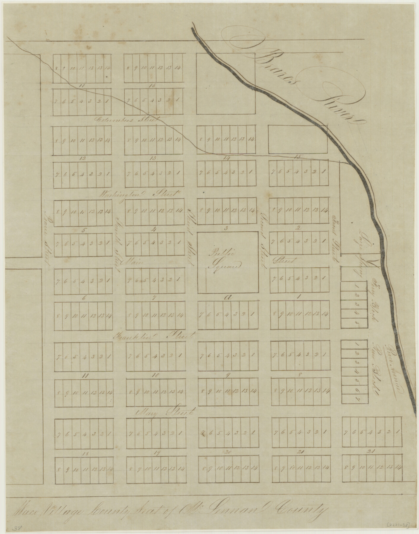
Waco Village, County Seat of McLennan County
-
Map/Doc
76268
-
Collection
Texas State Library and Archives
-
Object Dates
1850 (Creation Date)
-
Counties
McLennan
-
Subjects
City
-
Height x Width
15.8 x 12.4 inches
40.1 x 31.5 cm
-
Comments
Prints available courtesy of the Texas State Library and Archives.
More info can be found here: TSLAC Map 02221-38
Part of: Texas State Library and Archives
Map of Texas and the Countries Adjacent compiled in the Bureau of the Corps of Topographical Engineers from the Best Authorities

Print $20.00
Map of Texas and the Countries Adjacent compiled in the Bureau of the Corps of Topographical Engineers from the Best Authorities
1844
Size 24.5 x 35.8 inches
Map/Doc 76197
General Highway Map, Dawson County, Texas

Print $20.00
General Highway Map, Dawson County, Texas
1961
Size 18.0 x 24.5 inches
Map/Doc 79436
General Highway Map. Detail of Cities and Towns in Tarrant County, Texas. City Map, Fort Worth and vicinity, Tarrant County, Texas

Print $20.00
General Highway Map. Detail of Cities and Towns in Tarrant County, Texas. City Map, Fort Worth and vicinity, Tarrant County, Texas
1961
Size 18.1 x 24.9 inches
Map/Doc 79668
General Highway Map, Waller County, Texas

Print $20.00
General Highway Map, Waller County, Texas
1939
Size 25.1 x 18.5 inches
Map/Doc 79270
General Highway Map Supplementary Sheet Showing Detail of Cities and Towns in Bexar County Texas

Print $20.00
General Highway Map Supplementary Sheet Showing Detail of Cities and Towns in Bexar County Texas
1936
Size 18.5 x 25.0 inches
Map/Doc 76290
General Highway Map, Bastrop County, Texas

Print $20.00
General Highway Map, Bastrop County, Texas
1961
Size 18.3 x 24.8 inches
Map/Doc 79361
General Highway Map, Aransas County, Texas

Print $20.00
General Highway Map, Aransas County, Texas
1940
Size 18.4 x 25.0 inches
Map/Doc 79004
General Highway Map. Detail of Cities and Towns in Wharton County, Texas

Print $20.00
General Highway Map. Detail of Cities and Towns in Wharton County, Texas
1961
Size 18.3 x 24.8 inches
Map/Doc 79707
General Highway Map, Mills County, Texas

Print $20.00
General Highway Map, Mills County, Texas
1940
Size 18.4 x 24.8 inches
Map/Doc 79199
General Highway Map, Loving County, Texas

Print $20.00
General Highway Map, Loving County, Texas
1961
Size 18.1 x 24.6 inches
Map/Doc 79577
General Highway Map, Brooks County, Texas

Print $20.00
General Highway Map, Brooks County, Texas
1961
Size 18.2 x 24.8 inches
Map/Doc 79388
Map of the State of Coahuila and Texas

Print $20.00
Map of the State of Coahuila and Texas
1833
Size 16.1 x 20.2 inches
Map/Doc 76246
You may also like
A New Map of the United States of America

Print $20.00
A New Map of the United States of America
1856
Size 17.8 x 28.0 inches
Map/Doc 79320
Flight Mission No. CRK-5P, Frame 158, Refugio County

Print $20.00
- Digital $50.00
Flight Mission No. CRK-5P, Frame 158, Refugio County
1956
Size 18.6 x 22.5 inches
Map/Doc 86939
Crockett County Sketch File 65

Print $20.00
- Digital $50.00
Crockett County Sketch File 65
1927
Size 23.2 x 36.6 inches
Map/Doc 11230
Webb County Rolled Sketch 21

Print $20.00
- Digital $50.00
Webb County Rolled Sketch 21
1930
Size 32.9 x 23.0 inches
Map/Doc 8183
The Buffalo Bayou, Brazos and Colorado Railroad (BBB&C)

The Buffalo Bayou, Brazos and Colorado Railroad (BBB&C)
2022
Size 8.5 x 11.0 inches
Map/Doc 97088
[Block K, Public School Land]
![92907, [Block K, Public School Land], Twichell Survey Records](https://historictexasmaps.com/wmedia_w700/maps/92907-1.tif.jpg)
Print $20.00
- Digital $50.00
[Block K, Public School Land]
1902
Size 17.9 x 32.8 inches
Map/Doc 92907
Edwards County Sketch File 32

Print $40.00
- Digital $50.00
Edwards County Sketch File 32
1926
Size 13.1 x 14.4 inches
Map/Doc 21765
Plano del Presidio de Bahia dl Espiritus to dep te d' la Governacion de los Tejas

Plano del Presidio de Bahia dl Espiritus to dep te d' la Governacion de los Tejas
1766
Size 10.2 x 13.0 inches
Map/Doc 96516

Dickens County Working Sketch 15

Print $20.00
- Digital $50.00
Dickens County Working Sketch 15
2011
Size 28.8 x 28.6 inches
Map/Doc 90067
Limestone County Working Sketch 8

Print $20.00
- Digital $50.00
Limestone County Working Sketch 8
1922
Size 30.6 x 18.4 inches
Map/Doc 70558
Kimble County Sketch File 18

Print $22.00
- Digital $50.00
Kimble County Sketch File 18
1890
Size 8.8 x 14.2 inches
Map/Doc 28953