Falls County Sketch File 3

Print $3.00
- Digital $50.00
Falls County Sketch File 3
1847
Size: 10.8 x 16.5 inches
11465
Falls County Sketch File 16a

Print $20.00
- Digital $50.00
Falls County Sketch File 16a
1871
Size: 30.6 x 21.0 inches
11466
Set of new maps of Austin's Colony by G. Borden, Jr.

Print $20.00
- Digital $50.00
Set of new maps of Austin's Colony by G. Borden, Jr.
1833
Size: 25.0 x 17.0 inches
131
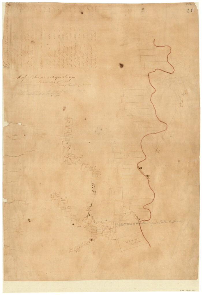
Map of Brassos [sic] & Bosque Surveys
Print $20.00
- Digital $50.00
Map of Brassos [sic] & Bosque Surveys
1841
Size: 27.7 x 18.9 inches
146
Bosque County Sketch File 3

Print $40.00
- Digital $50.00
Bosque County Sketch File 3
1848
Size: 16.1 x 12.4 inches
14742
Bosque County Sketch File 21

Print $12.00
- Digital $50.00
Bosque County Sketch File 21
1863
Size: 10.9 x 8.7 inches
14798
University and College Lands

Print $20.00
- Digital $50.00
University and College Lands
1841
Size: 21.3 x 27.0 inches
169
Coryell County Sketch File 2

Print $4.00
- Digital $50.00
Coryell County Sketch File 2
Size: 13.0 x 8.0 inches
19338
Coryell County Sketch File 6

Print $4.00
- Digital $50.00
Coryell County Sketch File 6
1858
Size: 8.2 x 9.8 inches
19347
Erath County Sketch File 4

Print $8.00
- Digital $50.00
Erath County Sketch File 4
1853
Size: 13.1 x 8.3 inches
22259
Falls County Sketch File 6

Print $4.00
- Digital $50.00
Falls County Sketch File 6
1848
Size: 12.8 x 8.3 inches
22341
Falls County Sketch File 10

Print $14.00
- Digital $50.00
Falls County Sketch File 10
Size: 12.9 x 8.4 inches
22345
Falls County Sketch File 14

Print $40.00
- Digital $50.00
Falls County Sketch File 14
Size: 15.9 x 12.9 inches
22370
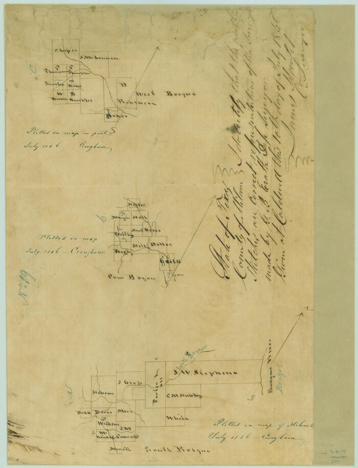
[Surveys in the Milam District along the Brazos River, North Bosque River, West Bosque River and Cow Bayou]
Print $2.00
- Digital $50.00
[Surveys in the Milam District along the Brazos River, North Bosque River, West Bosque River and Cow Bayou]
1846
Size: 11.7 x 8.9 inches
231
[Surveys along Bosque and Hog Creek]
Print $20.00
- Digital $50.00
[Surveys along Bosque and Hog Creek]
1845
Size: 23.9 x 17.0 inches
238
Map of University Land in McLennan County

Print $20.00
- Digital $50.00
Map of University Land in McLennan County
1905
Size: 35.1 x 32.9 inches
2432
Jeff Davis County Sketch File 2a

Print $4.00
- Digital $50.00
Jeff Davis County Sketch File 2a
Size: 8.3 x 3.3 inches
27890
Limestone County Sketch File 7

Print $4.00
- Digital $50.00
Limestone County Sketch File 7
1862
Size: 13.3 x 7.9 inches
30169
Limestone County Sketch File 10a

Print $22.00
- Digital $50.00
Limestone County Sketch File 10a
Size: 12.5 x 15.8 inches
30173
Limestone County Sketch File 10b

Print $22.00
- Digital $50.00
Limestone County Sketch File 10b
1875
Size: 15.0 x 14.1 inches
30175
Sketch of surveys made by Erath and Green in August 1846 on the waters of the Bosque River

Print $2.00
- Digital $50.00
Sketch of surveys made by Erath and Green in August 1846 on the waters of the Bosque River
1846
Size: 10.6 x 7.8 inches
303
[Surveys along Cow and Deer Creeks]

Print $2.00
- Digital $50.00
[Surveys along Cow and Deer Creeks]
1845
Size: 15.8 x 8.6 inches
306
McLennan County Sketch File 1

Print $4.00
- Digital $50.00
McLennan County Sketch File 1
Size: 11.5 x 8.4 inches
31224
McLennan County Sketch File 1a

Print $4.00
- Digital $50.00
McLennan County Sketch File 1a
1872
Size: 8.0 x 12.2 inches
31226
McLennan County Sketch File 1b

Print $4.00
- Digital $50.00
McLennan County Sketch File 1b
Size: 8.3 x 8.1 inches
31228
McLennan County Sketch File 2

Print $6.00
- Digital $50.00
McLennan County Sketch File 2
1856
Size: 11.5 x 7.7 inches
31230
McLennan County Sketch File 3

Print $4.00
- Digital $50.00
McLennan County Sketch File 3
1857
Size: 11.1 x 8.1 inches
31233
McLennan County Sketch File 4

Print $4.00
- Digital $50.00
McLennan County Sketch File 4
1852
Size: 12.7 x 8.2 inches
31235
McLennan County Sketch File 4a

Print $6.00
- Digital $50.00
McLennan County Sketch File 4a
Size: 9.2 x 7.9 inches
31237
Falls County Sketch File 3
Print $3.00
- Digital $50.00
Falls County Sketch File 3
1847
-
Size
10.8 x 16.5 inches
-
Map/Doc
11465
-
Creation Date
1847
Falls County Sketch File 16a
Print $20.00
- Digital $50.00
Falls County Sketch File 16a
1871
-
Size
30.6 x 21.0 inches
-
Map/Doc
11466
-
Creation Date
1871
Set of new maps of Austin's Colony by G. Borden, Jr.
Print $20.00
- Digital $50.00
Set of new maps of Austin's Colony by G. Borden, Jr.
1833
-
Size
25.0 x 17.0 inches
-
Map/Doc
131
-
Creation Date
1833
Map of Brassos [sic] & Bosque Surveys
Print $20.00
- Digital $50.00
Map of Brassos [sic] & Bosque Surveys
1841
-
Size
27.7 x 18.9 inches
-
Map/Doc
146
-
Creation Date
1841
Bosque County Sketch File 3
Print $40.00
- Digital $50.00
Bosque County Sketch File 3
1848
-
Size
16.1 x 12.4 inches
-
Map/Doc
14742
-
Creation Date
1848
Bosque County Sketch File 21
Print $12.00
- Digital $50.00
Bosque County Sketch File 21
1863
-
Size
10.9 x 8.7 inches
-
Map/Doc
14798
-
Creation Date
1863
University and College Lands
Print $20.00
- Digital $50.00
University and College Lands
1841
-
Size
21.3 x 27.0 inches
-
Map/Doc
169
-
Creation Date
1841
McLennan County

Print $20.00
- Digital $50.00
McLennan County
1946
-
Size
43.9 x 46.8 inches
-
Map/Doc
1887
-
Creation Date
1946
Coryell County Sketch File 2
Print $4.00
- Digital $50.00
Coryell County Sketch File 2
-
Size
13.0 x 8.0 inches
-
Map/Doc
19338
Coryell County Sketch File 6
Print $4.00
- Digital $50.00
Coryell County Sketch File 6
1858
-
Size
8.2 x 9.8 inches
-
Map/Doc
19347
-
Creation Date
1858
Erath County Sketch File 4
Print $8.00
- Digital $50.00
Erath County Sketch File 4
1853
-
Size
13.1 x 8.3 inches
-
Map/Doc
22259
-
Creation Date
1853
Falls County Sketch File 6
Print $4.00
- Digital $50.00
Falls County Sketch File 6
1848
-
Size
12.8 x 8.3 inches
-
Map/Doc
22341
-
Creation Date
1848
Falls County Sketch File 10
Print $14.00
- Digital $50.00
Falls County Sketch File 10
-
Size
12.9 x 8.4 inches
-
Map/Doc
22345
Falls County Sketch File 14
Print $40.00
- Digital $50.00
Falls County Sketch File 14
-
Size
15.9 x 12.9 inches
-
Map/Doc
22370
[Surveys in the Milam District along the Brazos River, North Bosque River, West Bosque River and Cow Bayou]
Print $2.00
- Digital $50.00
[Surveys in the Milam District along the Brazos River, North Bosque River, West Bosque River and Cow Bayou]
1846
-
Size
11.7 x 8.9 inches
-
Map/Doc
231
-
Creation Date
1846
[Surveys along Bosque and Hog Creek]
Print $20.00
- Digital $50.00
[Surveys along Bosque and Hog Creek]
1845
-
Size
23.9 x 17.0 inches
-
Map/Doc
238
-
Creation Date
1845
Map of University Land in McLennan County
Print $20.00
- Digital $50.00
Map of University Land in McLennan County
1905
-
Size
35.1 x 32.9 inches
-
Map/Doc
2432
-
Creation Date
1905
Jeff Davis County Sketch File 2a
Print $4.00
- Digital $50.00
Jeff Davis County Sketch File 2a
-
Size
8.3 x 3.3 inches
-
Map/Doc
27890
Limestone County Sketch File 7
Print $4.00
- Digital $50.00
Limestone County Sketch File 7
1862
-
Size
13.3 x 7.9 inches
-
Map/Doc
30169
-
Creation Date
1862
Limestone County Sketch File 10a
Print $22.00
- Digital $50.00
Limestone County Sketch File 10a
-
Size
12.5 x 15.8 inches
-
Map/Doc
30173
Limestone County Sketch File 10b
Print $22.00
- Digital $50.00
Limestone County Sketch File 10b
1875
-
Size
15.0 x 14.1 inches
-
Map/Doc
30175
-
Creation Date
1875
Sketch of surveys made by Erath and Green in August 1846 on the waters of the Bosque River
Print $2.00
- Digital $50.00
Sketch of surveys made by Erath and Green in August 1846 on the waters of the Bosque River
1846
-
Size
10.6 x 7.8 inches
-
Map/Doc
303
-
Creation Date
1846
[Surveys along Cow and Deer Creeks]
Print $2.00
- Digital $50.00
[Surveys along Cow and Deer Creeks]
1845
-
Size
15.8 x 8.6 inches
-
Map/Doc
306
-
Creation Date
1845
McLennan County Sketch File 1
Print $4.00
- Digital $50.00
McLennan County Sketch File 1
-
Size
11.5 x 8.4 inches
-
Map/Doc
31224
McLennan County Sketch File 1a
Print $4.00
- Digital $50.00
McLennan County Sketch File 1a
1872
-
Size
8.0 x 12.2 inches
-
Map/Doc
31226
-
Creation Date
1872
McLennan County Sketch File 1b
Print $4.00
- Digital $50.00
McLennan County Sketch File 1b
-
Size
8.3 x 8.1 inches
-
Map/Doc
31228
McLennan County Sketch File 2
Print $6.00
- Digital $50.00
McLennan County Sketch File 2
1856
-
Size
11.5 x 7.7 inches
-
Map/Doc
31230
-
Creation Date
1856
McLennan County Sketch File 3
Print $4.00
- Digital $50.00
McLennan County Sketch File 3
1857
-
Size
11.1 x 8.1 inches
-
Map/Doc
31233
-
Creation Date
1857
McLennan County Sketch File 4
Print $4.00
- Digital $50.00
McLennan County Sketch File 4
1852
-
Size
12.7 x 8.2 inches
-
Map/Doc
31235
-
Creation Date
1852
McLennan County Sketch File 4a
Print $6.00
- Digital $50.00
McLennan County Sketch File 4a
-
Size
9.2 x 7.9 inches
-
Map/Doc
31237