Belton and Stillhouse Hollow Reservoirs (Recto)

Belton and Stillhouse Hollow Reservoirs (Recto)
1972
Size: 29.1 x 22.6 inches
94172
Belton and Stillhouse Hollow Reservoirs (Verso)

Belton and Stillhouse Hollow Reservoirs (Verso)
1972
Size: 29.3 x 22.7 inches
94173
Bird's Eye View of the City of Waco

Print $20.00
Bird's Eye View of the City of Waco
1873
Size: 19.6 x 24.0 inches
89211
Bosque County Sketch File 21

Print $12.00
- Digital $50.00
Bosque County Sketch File 21
1863
Size: 10.9 x 8.7 inches
14798
Bosque County Sketch File 3

Print $40.00
- Digital $50.00
Bosque County Sketch File 3
1848
Size: 16.1 x 12.4 inches
14742
Bosque County Working Sketch 24

Print $20.00
- Digital $50.00
Bosque County Working Sketch 24
1994
Size: 34.4 x 47.4 inches
67457
Bosque County Working Sketch 24

Print $20.00
- Digital $50.00
Bosque County Working Sketch 24
1994
Size: 34.6 x 47.3 inches
67458
Brazos River, East Waco Sheet

Print $6.00
- Digital $50.00
Brazos River, East Waco Sheet
1928
Size: 31.6 x 25.9 inches
65283
Brazos River, Gurley Sheet

Print $6.00
- Digital $50.00
Brazos River, Gurley Sheet
1929
Size: 33.1 x 30.2 inches
65282
Coryell County Sketch File 2

Print $4.00
- Digital $50.00
Coryell County Sketch File 2
Size: 13.0 x 8.0 inches
19338
Coryell County Sketch File 6

Print $4.00
- Digital $50.00
Coryell County Sketch File 6
1858
Size: 8.2 x 9.8 inches
19347
English Field Notes of the Spanish Archives - Book A-B

English Field Notes of the Spanish Archives - Book A-B
1835
96540
English Field Notes of the Spanish Archives - Book C

English Field Notes of the Spanish Archives - Book C
1835
96541
English Field Notes of the Spanish Archives - Books BTB, GA, BT, and X

English Field Notes of the Spanish Archives - Books BTB, GA, BT, and X
1835
96554
Erath County Sketch File 4

Print $8.00
- Digital $50.00
Erath County Sketch File 4
1853
Size: 13.1 x 8.3 inches
22259
Falls County Sketch File 10

Print $14.00
- Digital $50.00
Falls County Sketch File 10
Size: 12.9 x 8.4 inches
22345
Falls County Sketch File 14

Print $40.00
- Digital $50.00
Falls County Sketch File 14
Size: 15.9 x 12.9 inches
22370
Falls County Sketch File 16a

Print $20.00
- Digital $50.00
Falls County Sketch File 16a
1871
Size: 30.6 x 21.0 inches
11466
Falls County Sketch File 29

Print $40.00
- Digital $50.00
Falls County Sketch File 29
Size: 19.9 x 23.5 inches
75994
Falls County Sketch File 3

Print $3.00
- Digital $50.00
Falls County Sketch File 3
1847
Size: 10.8 x 16.5 inches
11465
Falls County Sketch File 6

Print $4.00
- Digital $50.00
Falls County Sketch File 6
1848
Size: 12.8 x 8.3 inches
22341
Field notes for subdivisions of University Leagues/Surveys in Fannin, Grayson, McLennan, Hunt, Lamar, Collin, and Cooke Counties

Field notes for subdivisions of University Leagues/Surveys in Fannin, Grayson, McLennan, Hunt, Lamar, Collin, and Cooke Counties
81727
General Highway Map, McLennan County, Texas

Print $20.00
General Highway Map, McLennan County, Texas
1940
Size: 18.3 x 24.6 inches
79191
General Highway Map, McLennan County, Texas

Print $20.00
General Highway Map, McLennan County, Texas
1961
Size: 18.2 x 24.6 inches
79589
General Highway Map. Detail of Cities and Towns in McLennan County, Texas

Print $20.00
General Highway Map. Detail of Cities and Towns in McLennan County, Texas
1961
Size: 18.2 x 24.6 inches
79591
General Highway Map. Detail of Cities and Towns in McLennan County, Texas [Waco and vicinity]
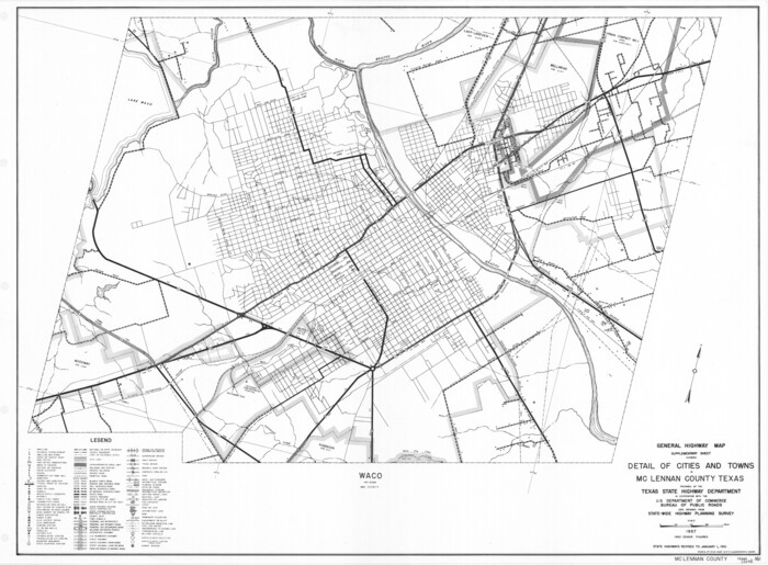
Print $20.00
General Highway Map. Detail of Cities and Towns in McLennan County, Texas [Waco and vicinity]
1961
Size: 18.1 x 24.6 inches
79590
General Highway Map. Detail of Cities and Towns in McLennan County, Texas [Waco and vicinity]
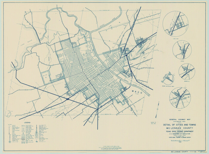
Print $20.00
General Highway Map. Detail of Cities and Towns in McLennan County, Texas [Waco and vicinity]
1940
Size: 18.2 x 24.7 inches
79192
Jeff Davis County Sketch File 2a

Print $4.00
- Digital $50.00
Jeff Davis County Sketch File 2a
Size: 8.3 x 3.3 inches
27890
Limestone County Sketch File 10a

Print $22.00
- Digital $50.00
Limestone County Sketch File 10a
Size: 12.5 x 15.8 inches
30173
Limestone County Sketch File 10b

Print $22.00
- Digital $50.00
Limestone County Sketch File 10b
1875
Size: 15.0 x 14.1 inches
30175
Belton and Stillhouse Hollow Reservoirs (Recto)
Belton and Stillhouse Hollow Reservoirs (Recto)
1972
-
Size
29.1 x 22.6 inches
-
Map/Doc
94172
-
Creation Date
1972
Belton and Stillhouse Hollow Reservoirs (Verso)
Belton and Stillhouse Hollow Reservoirs (Verso)
1972
-
Size
29.3 x 22.7 inches
-
Map/Doc
94173
-
Creation Date
1972
Bird's Eye View of the City of Waco
Print $20.00
Bird's Eye View of the City of Waco
1873
-
Size
19.6 x 24.0 inches
-
Map/Doc
89211
-
Creation Date
1873
Bosque County Sketch File 21
Print $12.00
- Digital $50.00
Bosque County Sketch File 21
1863
-
Size
10.9 x 8.7 inches
-
Map/Doc
14798
-
Creation Date
1863
Bosque County Sketch File 3
Print $40.00
- Digital $50.00
Bosque County Sketch File 3
1848
-
Size
16.1 x 12.4 inches
-
Map/Doc
14742
-
Creation Date
1848
Bosque County Working Sketch 24
Print $20.00
- Digital $50.00
Bosque County Working Sketch 24
1994
-
Size
34.4 x 47.4 inches
-
Map/Doc
67457
-
Creation Date
1994
Bosque County Working Sketch 24
Print $20.00
- Digital $50.00
Bosque County Working Sketch 24
1994
-
Size
34.6 x 47.3 inches
-
Map/Doc
67458
-
Creation Date
1994
Brazos River, East Waco Sheet
Print $6.00
- Digital $50.00
Brazos River, East Waco Sheet
1928
-
Size
31.6 x 25.9 inches
-
Map/Doc
65283
-
Creation Date
1928
Brazos River, Gurley Sheet
Print $6.00
- Digital $50.00
Brazos River, Gurley Sheet
1929
-
Size
33.1 x 30.2 inches
-
Map/Doc
65282
-
Creation Date
1929
Coryell County Sketch File 2
Print $4.00
- Digital $50.00
Coryell County Sketch File 2
-
Size
13.0 x 8.0 inches
-
Map/Doc
19338
Coryell County Sketch File 6
Print $4.00
- Digital $50.00
Coryell County Sketch File 6
1858
-
Size
8.2 x 9.8 inches
-
Map/Doc
19347
-
Creation Date
1858
English Field Notes of the Spanish Archives - Book A-B
English Field Notes of the Spanish Archives - Book A-B
1835
-
Map/Doc
96540
-
Creation Date
1835
English Field Notes of the Spanish Archives - Book C
English Field Notes of the Spanish Archives - Book C
1835
-
Map/Doc
96541
-
Creation Date
1835
English Field Notes of the Spanish Archives - Books BTB, GA, BT, and X
English Field Notes of the Spanish Archives - Books BTB, GA, BT, and X
1835
-
Map/Doc
96554
-
Creation Date
1835
Erath County Sketch File 4
Print $8.00
- Digital $50.00
Erath County Sketch File 4
1853
-
Size
13.1 x 8.3 inches
-
Map/Doc
22259
-
Creation Date
1853
Falls County Sketch File 10
Print $14.00
- Digital $50.00
Falls County Sketch File 10
-
Size
12.9 x 8.4 inches
-
Map/Doc
22345
Falls County Sketch File 14
Print $40.00
- Digital $50.00
Falls County Sketch File 14
-
Size
15.9 x 12.9 inches
-
Map/Doc
22370
Falls County Sketch File 16a
Print $20.00
- Digital $50.00
Falls County Sketch File 16a
1871
-
Size
30.6 x 21.0 inches
-
Map/Doc
11466
-
Creation Date
1871
Falls County Sketch File 29
Print $40.00
- Digital $50.00
Falls County Sketch File 29
-
Size
19.9 x 23.5 inches
-
Map/Doc
75994
Falls County Sketch File 3
Print $3.00
- Digital $50.00
Falls County Sketch File 3
1847
-
Size
10.8 x 16.5 inches
-
Map/Doc
11465
-
Creation Date
1847
Falls County Sketch File 6
Print $4.00
- Digital $50.00
Falls County Sketch File 6
1848
-
Size
12.8 x 8.3 inches
-
Map/Doc
22341
-
Creation Date
1848
Field notes for subdivisions of University Leagues/Surveys in Fannin, Grayson, McLennan, Hunt, Lamar, Collin, and Cooke Counties
Field notes for subdivisions of University Leagues/Surveys in Fannin, Grayson, McLennan, Hunt, Lamar, Collin, and Cooke Counties
-
Map/Doc
81727
General Highway Map, McLennan County, Texas
Print $20.00
General Highway Map, McLennan County, Texas
1940
-
Size
18.3 x 24.6 inches
-
Map/Doc
79191
-
Creation Date
1940
General Highway Map, McLennan County, Texas
Print $20.00
General Highway Map, McLennan County, Texas
1961
-
Size
18.2 x 24.6 inches
-
Map/Doc
79589
-
Creation Date
1961
General Highway Map. Detail of Cities and Towns in McLennan County, Texas
Print $20.00
General Highway Map. Detail of Cities and Towns in McLennan County, Texas
1961
-
Size
18.2 x 24.6 inches
-
Map/Doc
79591
-
Creation Date
1961
General Highway Map. Detail of Cities and Towns in McLennan County, Texas [Waco and vicinity]
Print $20.00
General Highway Map. Detail of Cities and Towns in McLennan County, Texas [Waco and vicinity]
1961
-
Size
18.1 x 24.6 inches
-
Map/Doc
79590
-
Creation Date
1961
General Highway Map. Detail of Cities and Towns in McLennan County, Texas [Waco and vicinity]
Print $20.00
General Highway Map. Detail of Cities and Towns in McLennan County, Texas [Waco and vicinity]
1940
-
Size
18.2 x 24.7 inches
-
Map/Doc
79192
-
Creation Date
1940
Jeff Davis County Sketch File 2a
Print $4.00
- Digital $50.00
Jeff Davis County Sketch File 2a
-
Size
8.3 x 3.3 inches
-
Map/Doc
27890
Limestone County Sketch File 10a
Print $22.00
- Digital $50.00
Limestone County Sketch File 10a
-
Size
12.5 x 15.8 inches
-
Map/Doc
30173
Limestone County Sketch File 10b
Print $22.00
- Digital $50.00
Limestone County Sketch File 10b
1875
-
Size
15.0 x 14.1 inches
-
Map/Doc
30175
-
Creation Date
1875