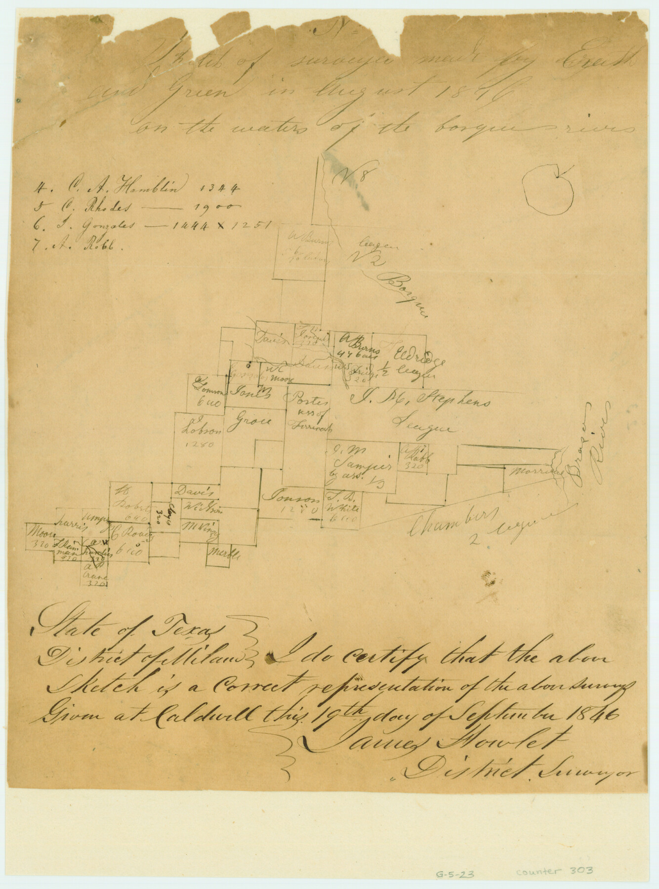
Sketch of surveys made by Erath and Green in August 1846 on the waters of the Bosque River
Atlas G, Page 5, Sketch 23 (G-5-23)
G-5-23
-
Map/Doc
303
-
Collection
General Map Collection
-
Object Dates
1846 (Creation Date)
-
People and Organizations
Erath & Green (Surveyor/Engineer)
-
Counties
McLennan
-
Subjects
Atlas
-
Height x Width
10.6 x 7.8 inches
26.9 x 19.8 cm
-
Medium
paper, manuscript
-
Comments
Conserved in 2004.
-
Features
Bosque River
Brazos River
Part of: General Map Collection
Gregg County Sketch File 12

Print $20.00
- Digital $50.00
Gregg County Sketch File 12
Size 17.3 x 24.1 inches
Map/Doc 11589
Plan de la Villa de Austin

Print $20.00
- Digital $50.00
Plan de la Villa de Austin
1828
Size 18.5 x 12.5 inches
Map/Doc 94116
Howard County

Print $20.00
- Digital $50.00
Howard County
1922
Size 44.0 x 37.5 inches
Map/Doc 66872
Crockett County

Print $40.00
- Digital $50.00
Crockett County
1882
Size 57.2 x 38.3 inches
Map/Doc 88864
Brewster County Rolled Sketch 68

Print $20.00
- Digital $50.00
Brewster County Rolled Sketch 68
1940
Size 20.2 x 29.9 inches
Map/Doc 5234
Edwards County Working Sketch 10

Print $20.00
- Digital $50.00
Edwards County Working Sketch 10
1920
Size 21.9 x 18.3 inches
Map/Doc 68886
Goliad County Working Sketch 6

Print $20.00
- Digital $50.00
Goliad County Working Sketch 6
1930
Size 20.9 x 22.2 inches
Map/Doc 63196
[Beaumont, Sour Lake and Western Ry. Right of Way and Alignment - Frisco]
![64121, [Beaumont, Sour Lake and Western Ry. Right of Way and Alignment - Frisco], General Map Collection](https://historictexasmaps.com/wmedia_w700/maps/64121.tif.jpg)
Print $20.00
- Digital $50.00
[Beaumont, Sour Lake and Western Ry. Right of Way and Alignment - Frisco]
1910
Size 20.0 x 45.8 inches
Map/Doc 64121
Falls County Sketch File 4

Print $4.00
- Digital $50.00
Falls County Sketch File 4
1856
Size 10.3 x 8.3 inches
Map/Doc 22335
Oldham County Sketch File 9

Print $20.00
- Digital $50.00
Oldham County Sketch File 9
1886
Size 18.4 x 26.1 inches
Map/Doc 12112
Jim Hogg County Working Sketch 3

Print $20.00
- Digital $50.00
Jim Hogg County Working Sketch 3
1939
Size 15.2 x 20.3 inches
Map/Doc 66589
Baylor County Rolled Sketch 12

Print $20.00
- Digital $50.00
Baylor County Rolled Sketch 12
1986
Size 22.4 x 36.0 inches
Map/Doc 5129
You may also like
[Original Muleshoe and vicinity]
![92504, [Original Muleshoe and vicinity], Twichell Survey Records](https://historictexasmaps.com/wmedia_w700/maps/92504-1.tif.jpg)
Print $20.00
- Digital $50.00
[Original Muleshoe and vicinity]
Size 36.0 x 23.6 inches
Map/Doc 92504
Flight Mission No. BRA-16M, Frame 76, Jefferson County

Print $20.00
- Digital $50.00
Flight Mission No. BRA-16M, Frame 76, Jefferson County
1953
Size 18.6 x 22.3 inches
Map/Doc 85693
The Republic County of Jefferson. December 29, 1845

Print $20.00
The Republic County of Jefferson. December 29, 1845
2020
Size 22.6 x 21.7 inches
Map/Doc 96201
Hutchinson County Sketch File 26

Print $20.00
- Digital $50.00
Hutchinson County Sketch File 26
1920
Size 18.6 x 17.4 inches
Map/Doc 11816
Duval County Working Sketch 17

Print $20.00
- Digital $50.00
Duval County Working Sketch 17
1939
Size 14.6 x 25.1 inches
Map/Doc 68730
Harris County Sketch File 84

Print $20.00
- Digital $50.00
Harris County Sketch File 84
1950
Size 23.1 x 35.7 inches
Map/Doc 11672
Uvalde County Working Sketch 67

Print $20.00
- Digital $50.00
Uvalde County Working Sketch 67
1956
Size 22.8 x 20.9 inches
Map/Doc 75973
Flight Mission No. DIX-5P, Frame 108, Aransas County

Print $20.00
- Digital $50.00
Flight Mission No. DIX-5P, Frame 108, Aransas County
1956
Size 17.2 x 18.1 inches
Map/Doc 83787
San Augustine County Working Sketch 22

Print $20.00
- Digital $50.00
San Augustine County Working Sketch 22
1974
Size 16.1 x 29.0 inches
Map/Doc 63710
General Highway Map, Brazos County, Texas

Print $20.00
General Highway Map, Brazos County, Texas
1961
Size 24.9 x 18.3 inches
Map/Doc 79384
Concho County

Print $20.00
- Digital $50.00
Concho County
1947
Size 46.8 x 36.9 inches
Map/Doc 73115
Mills County Working Sketch 1

Print $20.00
- Digital $50.00
Mills County Working Sketch 1
Size 18.2 x 23.4 inches
Map/Doc 71031