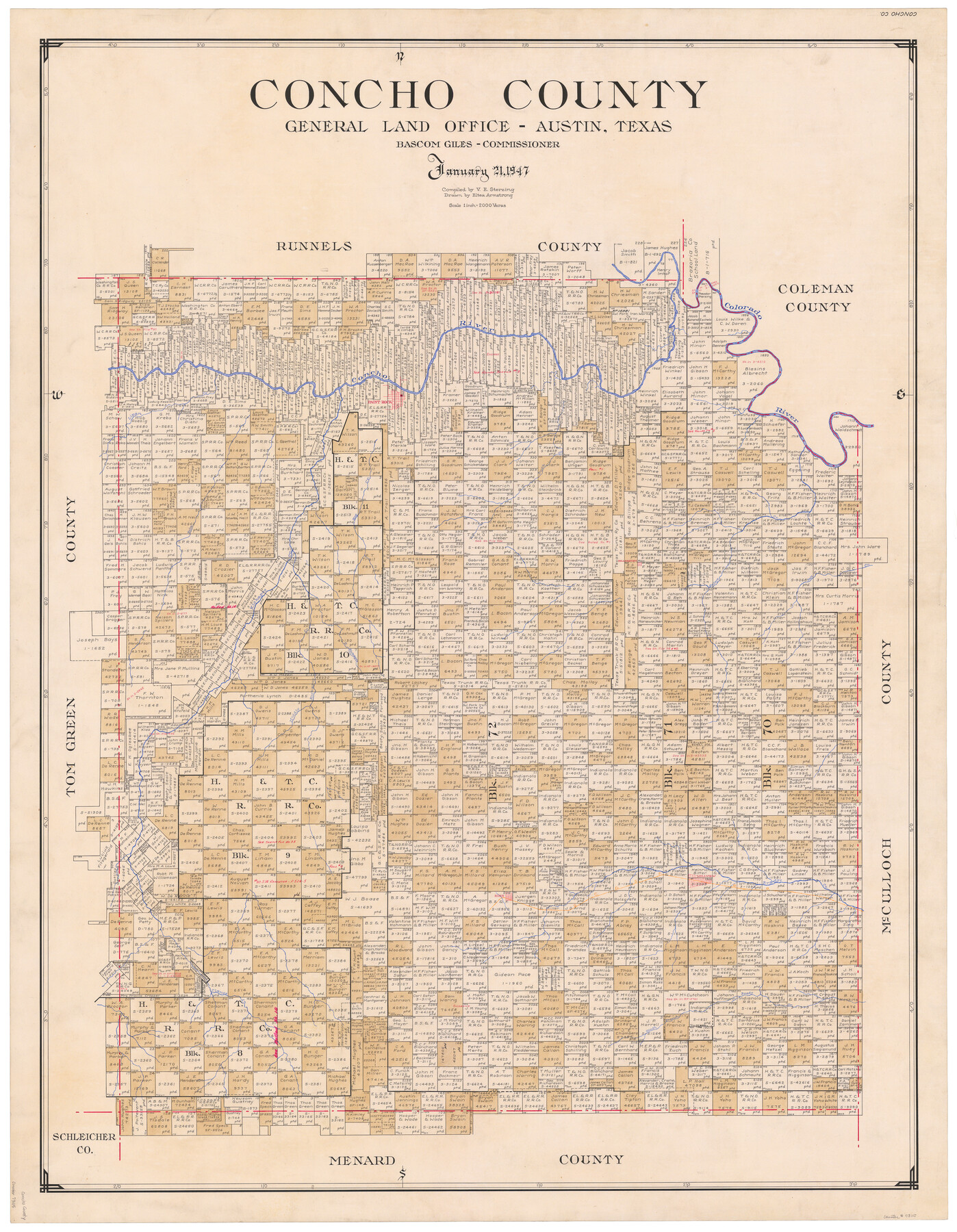
Concho County
-
Map/Doc
73115
-
Collection
General Map Collection
-
Object Dates
1/21/1947 (Creation Date)
-
People and Organizations
Texas General Land Office (Publisher)
Eltea Armstrong (Draftsman)
Bascom Giles (GLO Commissioner)
Victor E. Sterzing (Compiler)
-
Counties
Concho
-
Subjects
County
-
Height x Width
46.8 x 36.9 inches
118.9 x 93.7 cm
-
Comments
Hand lettered.
Note on reverse side: "Compilation completed January 21, 1947. Inking completed May 20, 1947. Tracing completed September 25, 1947. Placed in official use September 25, 1947. Replaced [on sticks] by copy October 3, 1947." -
Features
East Kickapoo Creek
Eola Creek
Clauss Creek
South Branch of Bradys Creek
Bradys Creek
Wellview
GC&SF
Eden
Lipan Creek
Concho River
Middle Kickapoo Creek
Hog Creek
Duck Creek
Kelleys Creek
Salt Creek
Colorado River
Paint Rock
Part of: General Map Collection
[Beaumont, Sour Lake and Western Ry. Right of Way and Alignment - Frisco]
![64115, [Beaumont, Sour Lake and Western Ry. Right of Way and Alignment - Frisco], General Map Collection](https://historictexasmaps.com/wmedia_w700/maps/64115.tif.jpg)
Print $20.00
- Digital $50.00
[Beaumont, Sour Lake and Western Ry. Right of Way and Alignment - Frisco]
1910
Size 20.1 x 45.9 inches
Map/Doc 64115
Map of Cherokee County

Print $20.00
- Digital $50.00
Map of Cherokee County
1848
Size 27.1 x 20.6 inches
Map/Doc 3390
Reclamation & Navigation Map of Trinity River Flood Plain

Print $40.00
- Digital $50.00
Reclamation & Navigation Map of Trinity River Flood Plain
1930
Size 24.3 x 75.8 inches
Map/Doc 65178
Trinity County Sketch File 38

Print $8.00
- Digital $50.00
Trinity County Sketch File 38
1948
Size 14.5 x 8.9 inches
Map/Doc 38593
Presidio County Working Sketch 63

Print $40.00
- Digital $50.00
Presidio County Working Sketch 63
1958
Size 64.8 x 38.9 inches
Map/Doc 71740
Bandera County Working Sketch 11

Print $20.00
- Digital $50.00
Bandera County Working Sketch 11
1928
Size 17.8 x 27.4 inches
Map/Doc 67604
State of Texas

Print $40.00
- Digital $50.00
State of Texas
1948
Size 44.6 x 56.8 inches
Map/Doc 78634
Calcasieu Pass to Sabine Pass

Print $20.00
- Digital $50.00
Calcasieu Pass to Sabine Pass
1992
Size 44.5 x 35.8 inches
Map/Doc 69815
Panola County Working Sketch 23

Print $20.00
- Digital $50.00
Panola County Working Sketch 23
1951
Map/Doc 71432
Rusk County Sketch File 9

Print $4.00
Rusk County Sketch File 9
1849
Size 8.4 x 8.2 inches
Map/Doc 35505
Mason County Boundary File 5a

Print $40.00
- Digital $50.00
Mason County Boundary File 5a
Size 18.0 x 32.6 inches
Map/Doc 56872
Baylor County Rolled Sketch BHK

Print $20.00
- Digital $50.00
Baylor County Rolled Sketch BHK
1892
Size 18.8 x 43.5 inches
Map/Doc 5130
You may also like
Map of San Patricio County

Print $40.00
- Digital $50.00
Map of San Patricio County
1840
Size 48.7 x 57.2 inches
Map/Doc 77095
Coryell County Working Sketch 13

Print $20.00
- Digital $50.00
Coryell County Working Sketch 13
1950
Size 20.9 x 22.7 inches
Map/Doc 68220
General Highway Map, Harris County, Texas

Print $20.00
General Highway Map, Harris County, Texas
1939
Size 24.7 x 18.4 inches
Map/Doc 79115

Webb County Sketch File 6

Print $5.00
- Digital $50.00
Webb County Sketch File 6
1875
Size 7.3 x 13.7 inches
Map/Doc 39735
[Sketch for Mineral Application 33721 - 33725 Incl. - Padre and Mustang Island]
![2877, [Sketch for Mineral Application 33721 - 33725 Incl. - Padre and Mustang Island], General Map Collection](https://historictexasmaps.com/wmedia_w700/maps/2877.tif.jpg)
Print $20.00
- Digital $50.00
[Sketch for Mineral Application 33721 - 33725 Incl. - Padre and Mustang Island]
1942
Size 29.8 x 22.6 inches
Map/Doc 2877
Ward County Working Sketch 9

Print $20.00
- Digital $50.00
Ward County Working Sketch 9
1946
Size 32.9 x 19.2 inches
Map/Doc 72315
Red River County Rolled Sketch 6

Print $40.00
- Digital $50.00
Red River County Rolled Sketch 6
1966
Size 58.1 x 45.2 inches
Map/Doc 9843
Wharton County Working Sketch 8

Print $20.00
- Digital $50.00
Wharton County Working Sketch 8
1983
Size 37.2 x 32.3 inches
Map/Doc 72472
Red River County Rolled Sketch 8

Print $20.00
- Digital $50.00
Red River County Rolled Sketch 8
Size 32.5 x 17.3 inches
Map/Doc 7474
Brewster County Rolled Sketch 98

Print $20.00
- Digital $50.00
Brewster County Rolled Sketch 98
1952
Size 29.3 x 38.0 inches
Map/Doc 8508
[Sketch showing H. & G. N. Block A on the north side of the Canadian River and H. & T. C. Block 46 on the south side of the Canadian River]
![91763, [Sketch showing H. & G. N. Block A on the north side of the Canadian River and H. & T. C. Block 46 on the south side of the Canadian River], Twichell Survey Records](https://historictexasmaps.com/wmedia_w700/maps/91763-1.tif.jpg)
Print $20.00
- Digital $50.00
[Sketch showing H. & G. N. Block A on the north side of the Canadian River and H. & T. C. Block 46 on the south side of the Canadian River]
1927
Size 25.1 x 11.2 inches
Map/Doc 91763