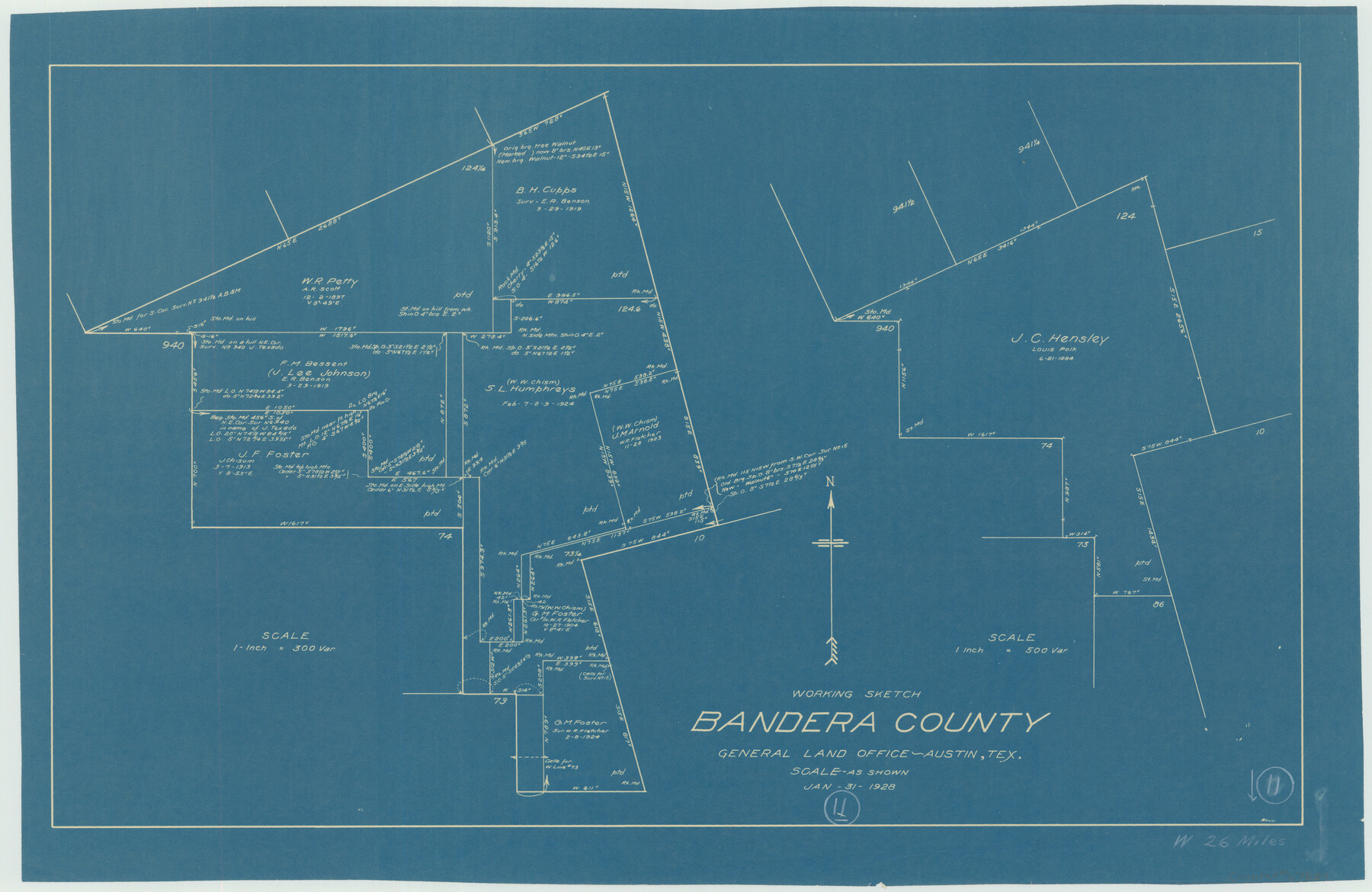
Bandera County Working Sketch 11
-
Map/Doc
67604
-
Collection
General Map Collection
-
Object Dates
1/31/1928 (Creation Date)
-
People and Organizations
W.K. Boggs (Draftsman)
-
Counties
Bandera
-
Subjects
Surveying Working Sketch
-
Height x Width
17.8 x 27.4 inches
45.2 x 69.6 cm
-
Scale
1" = 500 varas
-
Comments
Surveys located about 26 miles West of Bandera, Texas.
Part of: General Map Collection
Armstrong County Sketch File C

Print $46.00
- Digital $50.00
Armstrong County Sketch File C
1904
Size 16.4 x 15.7 inches
Map/Doc 10856
Sutton County Rolled Sketch H

Print $40.00
- Digital $50.00
Sutton County Rolled Sketch H
Size 24.9 x 50.0 inches
Map/Doc 9973
Loving County Rolled Sketch 15

Print $20.00
- Digital $50.00
Loving County Rolled Sketch 15
2015
Size 36.2 x 24.4 inches
Map/Doc 93793
Archer County Sketch File 11

Print $4.00
- Digital $50.00
Archer County Sketch File 11
Size 10.4 x 8.5 inches
Map/Doc 13644
Brewster County Working Sketch 12

Print $20.00
- Digital $50.00
Brewster County Working Sketch 12
1924
Size 36.9 x 21.4 inches
Map/Doc 67545
Bowie County Sketch File 7b

Print $10.00
- Digital $50.00
Bowie County Sketch File 7b
1927
Size 10.7 x 8.6 inches
Map/Doc 14859
Calhoun County Rolled Sketch 27

Print $127.00
- Digital $50.00
Calhoun County Rolled Sketch 27
1976
Size 10.1 x 16.0 inches
Map/Doc 43621
Gaines County

Print $40.00
- Digital $50.00
Gaines County
1956
Size 45.1 x 56.6 inches
Map/Doc 95504
El Paso County Sketch File 26

Print $20.00
- Digital $50.00
El Paso County Sketch File 26
Size 24.8 x 21.9 inches
Map/Doc 11457
Map showing S. A. & A. P. Ry. from San Antonio to Kendall County line

Print $40.00
- Digital $50.00
Map showing S. A. & A. P. Ry. from San Antonio to Kendall County line
1895
Size 25.1 x 76.7 inches
Map/Doc 64254
Hill County Working Sketch 4

Print $20.00
- Digital $50.00
Hill County Working Sketch 4
1982
Size 25.3 x 23.3 inches
Map/Doc 66190
Orange County Working Sketch 17

Print $20.00
- Digital $50.00
Orange County Working Sketch 17
1930
Size 35.6 x 26.1 inches
Map/Doc 71349
You may also like
Polk County Sketch File 12

Print $4.00
- Digital $50.00
Polk County Sketch File 12
Size 9.0 x 5.8 inches
Map/Doc 34146

Map Exhibit B, R. B. Violette, M. A. 34719, Gaines County, Texas

Print $20.00
- Digital $50.00
Map Exhibit B, R. B. Violette, M. A. 34719, Gaines County, Texas
Size 30.3 x 23.3 inches
Map/Doc 92654
Roberts County Working Sketch 40

Print $20.00
- Digital $50.00
Roberts County Working Sketch 40
1978
Size 26.6 x 22.6 inches
Map/Doc 63566
Garza County Sketch File 15

Print $20.00
- Digital $50.00
Garza County Sketch File 15
1902
Size 16.8 x 14.7 inches
Map/Doc 11545
Flight Mission No. DQN-2K, Frame 48, Calhoun County

Print $20.00
- Digital $50.00
Flight Mission No. DQN-2K, Frame 48, Calhoun County
1953
Size 17.1 x 22.2 inches
Map/Doc 84253
[Blocks W, A4, A2, T, D10, B, JD, O, JK4]
![92251, [Blocks W, A4, A2, T, D10, B, JD, O, JK4], Twichell Survey Records](https://historictexasmaps.com/wmedia_w700/maps/92251-1.tif.jpg)
Print $20.00
- Digital $50.00
[Blocks W, A4, A2, T, D10, B, JD, O, JK4]
Size 36.9 x 30.1 inches
Map/Doc 92251
Val Verde County Working Sketch 111

Print $20.00
- Digital $50.00
Val Verde County Working Sketch 111
1990
Size 40.1 x 24.8 inches
Map/Doc 72246
Field Notes of Mercer's Colony, Robertson, Nac[a]gdoches, Fannin, & Lamar Counties.
![1953, Field Notes of Mercer's Colony, Robertson, Nac[a]gdoches, Fannin, & Lamar Counties., General Map Collection](https://historictexasmaps.com/wmedia_w700/pdf_converted_jpg/qi_pdf_thumbnail_897.jpg)
Print $30.00
- Digital $50.00
Field Notes of Mercer's Colony, Robertson, Nac[a]gdoches, Fannin, & Lamar Counties.
1845
Size 9.5 x 14.8 inches
Map/Doc 1953
Upshur County Working Sketch 17

Print $40.00
- Digital $50.00
Upshur County Working Sketch 17
1997
Size 48.4 x 37.1 inches
Map/Doc 69575
Starr County Rolled Sketch 22

Print $20.00
- Digital $50.00
Starr County Rolled Sketch 22
1919
Size 37.3 x 22.3 inches
Map/Doc 7806
Liberty County Rolled Sketch L

Print $20.00
- Digital $50.00
Liberty County Rolled Sketch L
1950
Size 34.4 x 23.9 inches
Map/Doc 6624