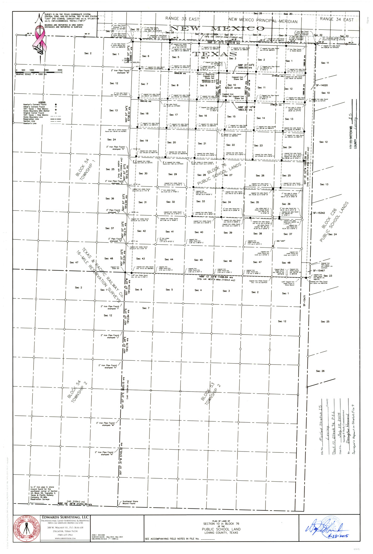
Loving County Rolled Sketch 15
Plan of land of section 10 in Block 76 of the Public School Land, Loving County, Texas
-
Map/Doc
93793
-
Collection
General Map Collection
-
Object Dates
2015/4/28 (Creation Date)
2015/7/10 (File Date)
2015 (Survey Date)
-
People and Organizations
Wm. Davey Edwards, PhD (Surveyor/Engineer)
-
Counties
Loving
-
Subjects
Surveying Rolled Sketch
-
Height x Width
36.2 x 24.4 inches
92.0 x 62.0 cm
-
Medium
mylar, print
-
Scale
1" = 1000 varas
-
Comments
See surveyor's report in Loving County Sketch File 9 (93794).
Related maps
Loving County Sketch File 9

Print $36.00
- Digital $50.00
Loving County Sketch File 9
2015
Size 14.0 x 8.5 inches
Map/Doc 93794
Loving County Rolled Sketch 17

Print $40.00
- Digital $50.00
Loving County Rolled Sketch 17
2022
Size 38.2 x 49.3 inches
Map/Doc 97292
Part of: General Map Collection
Flight Mission No. DAG-17K, Frame 60, Matagorda County

Print $20.00
- Digital $50.00
Flight Mission No. DAG-17K, Frame 60, Matagorda County
1952
Size 18.5 x 22.3 inches
Map/Doc 86322
Edwards County Working Sketch 38

Print $20.00
- Digital $50.00
Edwards County Working Sketch 38
1948
Size 28.4 x 43.9 inches
Map/Doc 68914
Harbor of Brazos Santiago, Texas

Print $20.00
- Digital $50.00
Harbor of Brazos Santiago, Texas
1887
Size 27.1 x 18.3 inches
Map/Doc 72997
Presidio County Rolled Sketch 70

Print $20.00
- Digital $50.00
Presidio County Rolled Sketch 70
1927
Size 37.1 x 13.9 inches
Map/Doc 7360
Comal County State Real Property Sketch 1

Print $134.00
- Digital $50.00
Comal County State Real Property Sketch 1
2006
Size 23.8 x 35.4 inches
Map/Doc 88635
Fort Bend County Working Sketch 13

Print $20.00
- Digital $50.00
Fort Bend County Working Sketch 13
1946
Size 29.0 x 29.3 inches
Map/Doc 69218
Cochran County Sketch File 3

Print $4.00
- Digital $50.00
Cochran County Sketch File 3
Size 8.8 x 11.3 inches
Map/Doc 18540
Flight Mission No. BRA-6M, Frame 142, Jefferson County

Print $20.00
- Digital $50.00
Flight Mission No. BRA-6M, Frame 142, Jefferson County
1953
Size 18.6 x 22.3 inches
Map/Doc 85443
Map of Kimble County

Print $40.00
- Digital $50.00
Map of Kimble County
1890
Size 36.1 x 54.4 inches
Map/Doc 78436
Flight Mission No. CRK-3P, Frame 62, Refugio County

Print $20.00
- Digital $50.00
Flight Mission No. CRK-3P, Frame 62, Refugio County
1956
Size 18.6 x 22.6 inches
Map/Doc 86904
Wise County Working Sketch 3

Print $20.00
- Digital $50.00
Wise County Working Sketch 3
1946
Size 28.4 x 36.9 inches
Map/Doc 72617
Nacogdoches County Working Sketch 5

Print $20.00
- Digital $50.00
Nacogdoches County Working Sketch 5
1949
Size 22.9 x 22.1 inches
Map/Doc 71221
You may also like
Map of Callahan County

Print $20.00
- Digital $50.00
Map of Callahan County
1878
Size 23.0 x 18.8 inches
Map/Doc 3361
General Highway Map Lamb County, Texas

Print $20.00
- Digital $50.00
General Highway Map Lamb County, Texas
1949
Size 19.0 x 26.0 inches
Map/Doc 92172
County Map of the Pan-Handle of Texas, and the line of the Denver, Texas and Ft. Worth R'y

Print $20.00
County Map of the Pan-Handle of Texas, and the line of the Denver, Texas and Ft. Worth R'y
1888
Size 7.5 x 10.9 inches
Map/Doc 76296
Zavala County Sketch File 43

Print $20.00
- Digital $50.00
Zavala County Sketch File 43
1915
Size 26.8 x 32.4 inches
Map/Doc 12733
Val Verde County Working Sketch 81

Print $20.00
- Digital $50.00
Val Verde County Working Sketch 81
1973
Size 24.6 x 41.7 inches
Map/Doc 72216
Jefferson County Working Sketch 32

Print $40.00
- Digital $50.00
Jefferson County Working Sketch 32
1981
Size 68.9 x 36.0 inches
Map/Doc 66576
The Republic County of Bastrop. January 25, 1840

Print $20.00
The Republic County of Bastrop. January 25, 1840
2020
Size 14.7 x 21.6 inches
Map/Doc 96091
Baylor County Sketch File 32

Print $10.00
- Digital $50.00
Baylor County Sketch File 32
Size 10.2 x 8.2 inches
Map/Doc 14238

Crosby County Working Sketch 7

Print $20.00
- Digital $50.00
Crosby County Working Sketch 7
1938
Size 33.8 x 21.6 inches
Map/Doc 68441
St. L. S-W. Ry. of Texas Map of Lufkin Branch in Cherokee County Texas

Print $40.00
- Digital $50.00
St. L. S-W. Ry. of Texas Map of Lufkin Branch in Cherokee County Texas
1912
Size 22.7 x 64.3 inches
Map/Doc 64019
Cooke County Sketch File 44

Print $20.00
- Digital $50.00
Cooke County Sketch File 44
1928
Size 20.4 x 20.6 inches
Map/Doc 11178