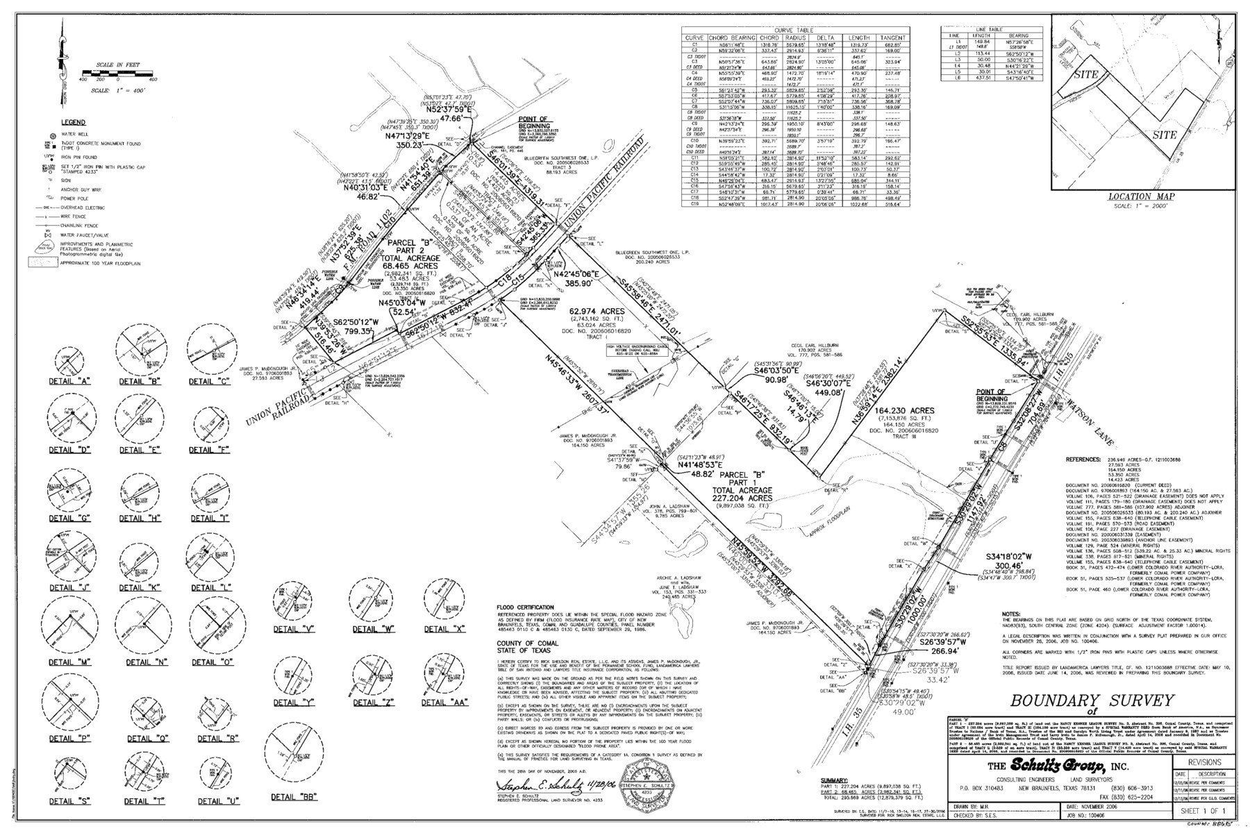
Comal County State Real Property Sketch 1
Field Notes and Survey of 635.060 Acres of Land Out of the Nancy Kenner League, Survey No. 3, A - 306
-
Map/Doc
88635
-
Collection
General Map Collection
-
Object Dates
2006 (Creation Date)
-
People and Organizations
The Schultz Group, Inc. (Publisher)
The Schultz Group, Inc. (Printer)
Stephen E. Schultz (Surveyor/Engineer)
M.H. (Draftsman)
-
Counties
Comal
-
Subjects
State Real Property
-
Height x Width
23.8 x 35.4 inches
60.5 x 89.9 cm
-
Comments
Surveys located about six miles North 38 degrees East of New Braunfels, Texas.
Part of: General Map Collection
Hartley County Working Sketch 4

Print $20.00
- Digital $50.00
Hartley County Working Sketch 4
1934
Size 23.9 x 30.6 inches
Map/Doc 66054
Childress County Sketch File 24

Print $4.00
- Digital $50.00
Childress County Sketch File 24
1917
Size 12.9 x 8.6 inches
Map/Doc 18384
Titus County Sketch File 14

Print $4.00
- Digital $50.00
Titus County Sketch File 14
Size 9.7 x 8.3 inches
Map/Doc 38157
Hardin County Sketch File 26

Print $7.00
- Digital $50.00
Hardin County Sketch File 26
Size 10.3 x 8.0 inches
Map/Doc 25148
Crockett County Rolled Sketch 88O

Print $126.00
- Digital $50.00
Crockett County Rolled Sketch 88O
1973
Size 9.8 x 15.1 inches
Map/Doc 44158
Jeff Davis County Working Sketch 43

Print $20.00
- Digital $50.00
Jeff Davis County Working Sketch 43
1983
Size 37.2 x 47.0 inches
Map/Doc 66538
Henderson County Rolled Sketch 11

Print $20.00
- Digital $50.00
Henderson County Rolled Sketch 11
1915
Size 27.2 x 40.3 inches
Map/Doc 75954
Henderson County Sketch File 25

Print $2.00
- Digital $50.00
Henderson County Sketch File 25
1854
Size 8.1 x 3.8 inches
Map/Doc 26391
Hutchinson County Working Sketch 43

Print $20.00
- Digital $50.00
Hutchinson County Working Sketch 43
1978
Size 26.6 x 22.3 inches
Map/Doc 66403
Flight Mission No. DAH-17M, Frame 23, Orange County

Print $20.00
- Digital $50.00
Flight Mission No. DAH-17M, Frame 23, Orange County
1953
Size 18.7 x 22.5 inches
Map/Doc 86886
Flight Mission No. DQN-3K, Frame 9, Calhoun County

Print $20.00
- Digital $50.00
Flight Mission No. DQN-3K, Frame 9, Calhoun County
1953
Size 18.6 x 22.2 inches
Map/Doc 84341

You may also like
A Pocket Guide to Austin, Texas - Area Map and Downtown Map

A Pocket Guide to Austin, Texas - Area Map and Downtown Map
Size 17.2 x 20.2 inches
Map/Doc 94386
Bravo Deed, Instrument 24, Tract A and Tract B

Print $3.00
- Digital $50.00
Bravo Deed, Instrument 24, Tract A and Tract B
Size 11.4 x 14.2 inches
Map/Doc 91479
Slaton-Tex Water System

Print $20.00
- Digital $50.00
Slaton-Tex Water System
1922
Size 47.7 x 37.6 inches
Map/Doc 92818
Wilbarger County Sketch File 7

Print $4.00
- Digital $50.00
Wilbarger County Sketch File 7
1883
Size 12.7 x 8.3 inches
Map/Doc 40175
Jack County Sketch File 15a

Print $6.00
- Digital $50.00
Jack County Sketch File 15a
1875
Size 14.7 x 10.2 inches
Map/Doc 27547
Crockett County Working Sketch 16

Print $20.00
- Digital $50.00
Crockett County Working Sketch 16
1917
Size 24.0 x 29.0 inches
Map/Doc 68349
Part of the boundary between the United States and Texas; north of Sabine River from the 36th to the 72nd mile mound

Print $3.00
- Digital $50.00
Part of the boundary between the United States and Texas; north of Sabine River from the 36th to the 72nd mile mound
1842
Size 12.0 x 8.8 inches
Map/Doc 93770

Flight Mission No. BRA-16M, Frame 170, Jefferson County

Print $20.00
- Digital $50.00
Flight Mission No. BRA-16M, Frame 170, Jefferson County
1953
Size 18.6 x 22.4 inches
Map/Doc 85768
The Republic County of Victoria. Proposed, Late Fall 1837-September 18, 1838

Print $20.00
The Republic County of Victoria. Proposed, Late Fall 1837-September 18, 1838
2020
Size 22.5 x 21.7 inches
Map/Doc 96295
Uvalde County Working Sketch 61

Print $20.00
- Digital $50.00
Uvalde County Working Sketch 61
1978
Size 40.4 x 37.4 inches
Map/Doc 72131
Presidio County Working Sketch 37
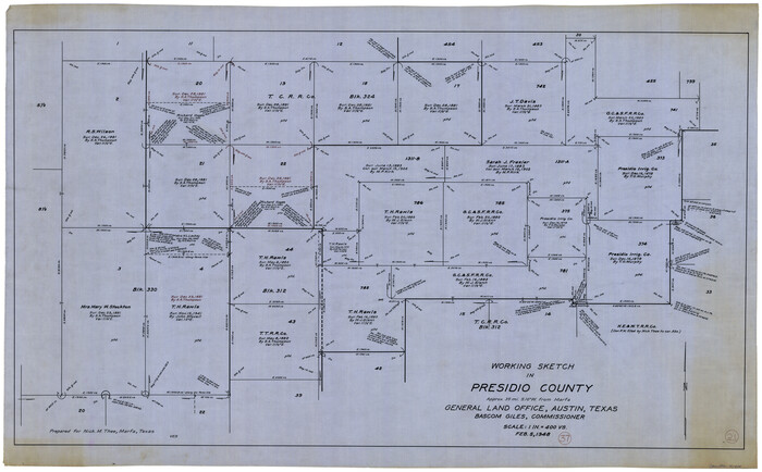
Print $20.00
- Digital $50.00
Presidio County Working Sketch 37
1948
Size 26.9 x 43.3 inches
Map/Doc 71714