Wilbarger County Sketch File 7
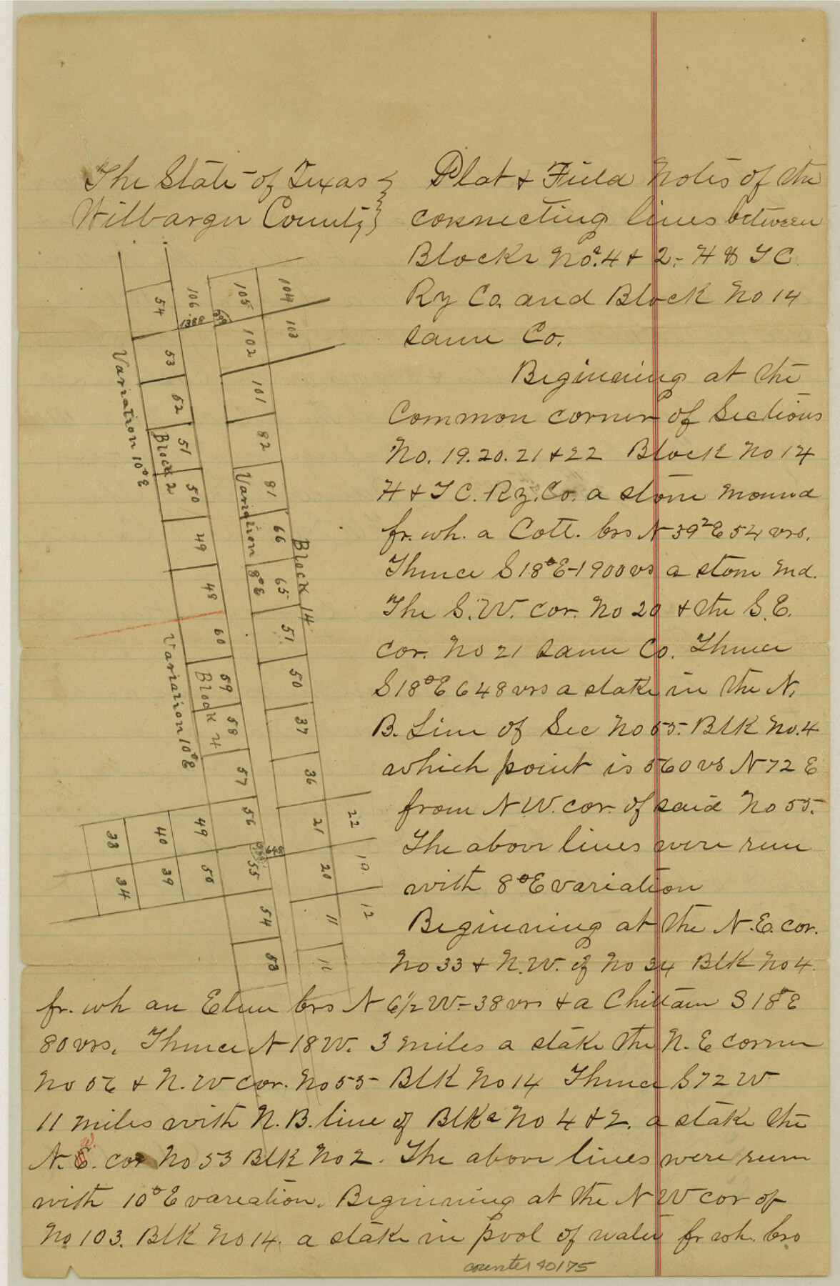
[Plat and field notes of the connecting lines between Blocks 2, 4, and 14, H. & T. C. R.R. Co.]
-
Map/Doc
40175
-
Collection
General Map Collection
-
Object Dates
5/1883 (Creation Date)
8/4/1883 (File Date)
-
People and Organizations
James Warren (Chainman/Field Personnel)
F.W. Jenkins (Chainman/Field Personnel)
W.J. Westmoreland (Surveyor/Engineer)
-
Counties
Wilbarger
-
Subjects
Surveying Sketch File
-
Height x Width
12.7 x 8.3 inches
32.3 x 21.1 cm
-
Medium
paper, manuscript
Part of: General Map Collection
Kleberg County Rolled Sketch 5A

Print $20.00
- Digital $50.00
Kleberg County Rolled Sketch 5A
Size 31.0 x 25.1 inches
Map/Doc 6549
Hutchinson County Working Sketch 21

Print $20.00
- Digital $50.00
Hutchinson County Working Sketch 21
1965
Size 35.0 x 40.8 inches
Map/Doc 66381

San Patricio County Rolled Sketch 51

Print $40.00
- Digital $50.00
San Patricio County Rolled Sketch 51
1988
Size 41.8 x 54.6 inches
Map/Doc 10635
Milam County Sketch File 7

Print $6.00
- Digital $50.00
Milam County Sketch File 7
1838
Size 13.0 x 8.0 inches
Map/Doc 31636

Zavala County Working Sketch 31

Print $20.00
- Digital $50.00
Zavala County Working Sketch 31
2019
Size 36.0 x 24.2 inches
Map/Doc 95407
Bailey County Sketch File 7

Print $8.00
- Digital $50.00
Bailey County Sketch File 7
1913
Size 14.0 x 8.7 inches
Map/Doc 13958
McMullen County Working Sketch 32

Print $20.00
- Digital $50.00
McMullen County Working Sketch 32
1958
Size 28.2 x 32.5 inches
Map/Doc 70733
Nueces County Rolled Sketch 71

Print $247.00
Nueces County Rolled Sketch 71
1980
Size 37.9 x 24.7 inches
Map/Doc 6924
Duval County Rolled Sketch 35

Print $20.00
- Digital $50.00
Duval County Rolled Sketch 35
1951
Size 23.5 x 17.0 inches
Map/Doc 5750
Randall County Rolled Sketch 2

Print $20.00
- Digital $50.00
Randall County Rolled Sketch 2
1941
Size 31.9 x 23.9 inches
Map/Doc 7422
You may also like
Cooke County Working Sketch 10

Print $20.00
- Digital $50.00
Cooke County Working Sketch 10
1940
Size 40.5 x 27.8 inches
Map/Doc 68247
[Adams Beaty & Moulton Block 2] / Map of Heller's Addition to Canyon City
![92121, [Adams Beaty & Moulton Block 2] / Map of Heller's Addition to Canyon City, Twichell Survey Records](https://historictexasmaps.com/wmedia_w700/maps/92121-1.tif.jpg)
Print $20.00
- Digital $50.00
[Adams Beaty & Moulton Block 2] / Map of Heller's Addition to Canyon City
Size 23.1 x 25.2 inches
Map/Doc 92121
Reagan County Rolled Sketch 12

Print $20.00
- Digital $50.00
Reagan County Rolled Sketch 12
1940
Size 25.9 x 27.0 inches
Map/Doc 7440
[Blocks 3T, 1, and 6T]
![91421, [Blocks 3T, 1, and 6T], Twichell Survey Records](https://historictexasmaps.com/wmedia_w700/maps/91421-1.tif.jpg)
Print $20.00
- Digital $50.00
[Blocks 3T, 1, and 6T]
Size 26.2 x 25.7 inches
Map/Doc 91421

Controlled Mosaic by Jack Amman Photogrammetric Engineers, Inc - Sheet 42

Print $20.00
- Digital $50.00
Controlled Mosaic by Jack Amman Photogrammetric Engineers, Inc - Sheet 42
1954
Size 20.0 x 24.0 inches
Map/Doc 83499
[Right of Way & Track Map, The Texas & Pacific Ry. Co. Main Line]
![64675, [Right of Way & Track Map, The Texas & Pacific Ry. Co. Main Line], General Map Collection](https://historictexasmaps.com/wmedia_w700/maps/64675.tif.jpg)
Print $20.00
- Digital $50.00
[Right of Way & Track Map, The Texas & Pacific Ry. Co. Main Line]
Size 11.0 x 18.4 inches
Map/Doc 64675
Red River County Working Sketch 54

Print $20.00
- Digital $50.00
Red River County Working Sketch 54
1971
Size 19.3 x 31.1 inches
Map/Doc 72037
Replat of Baker 2nd Addition to Lamesa, Part of Southwest Quarter, Section 71, Block 35, Dawson County, Texas

Print $20.00
- Digital $50.00
Replat of Baker 2nd Addition to Lamesa, Part of Southwest Quarter, Section 71, Block 35, Dawson County, Texas
1958
Size 9.9 x 18.8 inches
Map/Doc 92633
Hill County Sketch File 23

Print $8.00
- Digital $50.00
Hill County Sketch File 23
1862
Size 7.9 x 8.3 inches
Map/Doc 26512
Wharton County Working Sketch 5

Print $20.00
- Digital $50.00
Wharton County Working Sketch 5
Size 20.2 x 15.6 inches
Map/Doc 72469
Travis County State Real Property Sketch 16

Print $20.00
- Digital $50.00
Travis County State Real Property Sketch 16
2009
Size 48.1 x 36.1 inches
Map/Doc 90086