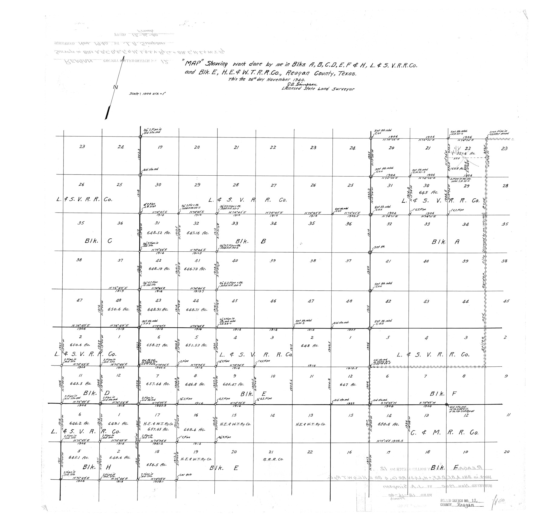
Reagan County Rolled Sketch 12
Map showing work done by [J.A. Simpson] in Blks. A, B, C, D, E, F, & H, L. & S. V. R.R. Co. and Blk. E, H. E. & W. T. R.R. Co., Reagan County, Texas
-
Map/Doc
7440
-
Collection
General Map Collection
-
Object Dates
1940/11/26 (Creation Date)
1940/12/16 (File Date)
-
People and Organizations
J.A. Simpson (Surveyor/Engineer)
-
Counties
Reagan
-
Subjects
Surveying Rolled Sketch
-
Height x Width
25.9 x 27.0 inches
65.8 x 68.6 cm
-
Scale
1" = 1000 varas
Part of: General Map Collection
Oldham County Rolled Sketch 2

Print $40.00
- Digital $50.00
Oldham County Rolled Sketch 2
1886
Size 35.7 x 55.1 inches
Map/Doc 9639
Index sheet to accompany map of survey for connecting the inland waters along margin of the Gulf of Mexico from Donaldsonville in Louisiana to the Rio Grande River in Texas

Print $20.00
- Digital $50.00
Index sheet to accompany map of survey for connecting the inland waters along margin of the Gulf of Mexico from Donaldsonville in Louisiana to the Rio Grande River in Texas
1874
Size 18.1 x 26.9 inches
Map/Doc 72694
Map of the City of Corsicana (Navarro County) Texas

Print $40.00
- Digital $50.00
Map of the City of Corsicana (Navarro County) Texas
1963
Size 43.2 x 92.3 inches
Map/Doc 93673
Polk County Working Sketch 42

Print $20.00
- Digital $50.00
Polk County Working Sketch 42
1992
Size 30.8 x 35.7 inches
Map/Doc 71659
[Surveys in Waller County]
![78367, [Surveys in Waller County], General Map Collection](https://historictexasmaps.com/wmedia_w700/maps/78367.tif.jpg)
Print $20.00
- Digital $50.00
[Surveys in Waller County]
Size 21.5 x 28.7 inches
Map/Doc 78367
Kendall County Working Sketch 18

Print $20.00
- Digital $50.00
Kendall County Working Sketch 18
1970
Size 43.2 x 33.3 inches
Map/Doc 66690
Leon County Working Sketch 9

Print $20.00
- Digital $50.00
Leon County Working Sketch 9
1949
Size 16.7 x 18.1 inches
Map/Doc 70408
[Bastrop District]
![3131, [Bastrop District], General Map Collection](https://historictexasmaps.com/wmedia_w700/maps/3131.tif.jpg)
Print $40.00
- Digital $50.00
[Bastrop District]
1895
Size 36.5 x 52.0 inches
Map/Doc 3131
Cass County Sketch File 7

Print $4.00
- Digital $50.00
Cass County Sketch File 7
1853
Size 8.0 x 12.6 inches
Map/Doc 17408
Liberty County Working Sketch 32

Print $20.00
- Digital $50.00
Liberty County Working Sketch 32
1945
Size 29.1 x 46.3 inches
Map/Doc 70491
Garza County Rolled Sketch 11

Print $20.00
- Digital $50.00
Garza County Rolled Sketch 11
1915
Size 31.6 x 20.8 inches
Map/Doc 6000
Madison County Working Sketch 6

Print $2.00
- Digital $50.00
Madison County Working Sketch 6
1982
Size 10.5 x 7.7 inches
Map/Doc 70768
You may also like
Aransas County Rolled Sketch 10

Print $58.00
- Digital $50.00
Aransas County Rolled Sketch 10
1936
Size 10.6 x 15.4 inches
Map/Doc 42208
La Salle County Working Sketch 11

Print $20.00
- Digital $50.00
La Salle County Working Sketch 11
1929
Size 29.3 x 20.7 inches
Map/Doc 70312
Presidio County Sketch File 62A

Print $20.00
- Digital $50.00
Presidio County Sketch File 62A
Size 14.6 x 20.8 inches
Map/Doc 11717
Old Miscellaneous File 10

Print $4.00
- Digital $50.00
Old Miscellaneous File 10
Size 9.6 x 8.2 inches
Map/Doc 75435
Galveston County NRC Article 33.136 Sketch 53

Print $24.00
- Digital $50.00
Galveston County NRC Article 33.136 Sketch 53
2009
Size 22.3 x 34.0 inches
Map/Doc 94609
Hopkins County Sketch File 4

Print $47.00
- Digital $50.00
Hopkins County Sketch File 4
Size 21.2 x 18.4 inches
Map/Doc 4565
Sulphur River, Terry Lake Sheet

Print $20.00
- Digital $50.00
Sulphur River, Terry Lake Sheet
1919
Size 28.6 x 30.9 inches
Map/Doc 65161
Reagan County

Print $40.00
- Digital $50.00
Reagan County
1940
Size 48.4 x 37.5 inches
Map/Doc 73270
Lloyd's New Military Map of the Border & Southern States

Print $20.00
- Digital $50.00
Lloyd's New Military Map of the Border & Southern States
1864
Size 32.4 x 44.0 inches
Map/Doc 97517
Harris County Sketch File A

Print $4.00
- Digital $50.00
Harris County Sketch File A
1898
Size 12.8 x 8.5 inches
Map/Doc 25306
[Galveston, Harrisburg & San Antonio Railroad from Cuero to Stockdale]
![64199, [Galveston, Harrisburg & San Antonio Railroad from Cuero to Stockdale], General Map Collection](https://historictexasmaps.com/wmedia_w700/maps/64199.tif.jpg)
Print $20.00
- Digital $50.00
[Galveston, Harrisburg & San Antonio Railroad from Cuero to Stockdale]
1907
Size 12.9 x 33.2 inches
Map/Doc 64199
Fayette County

Print $40.00
- Digital $50.00
Fayette County
1978
Size 43.6 x 56.1 inches
Map/Doc 95496