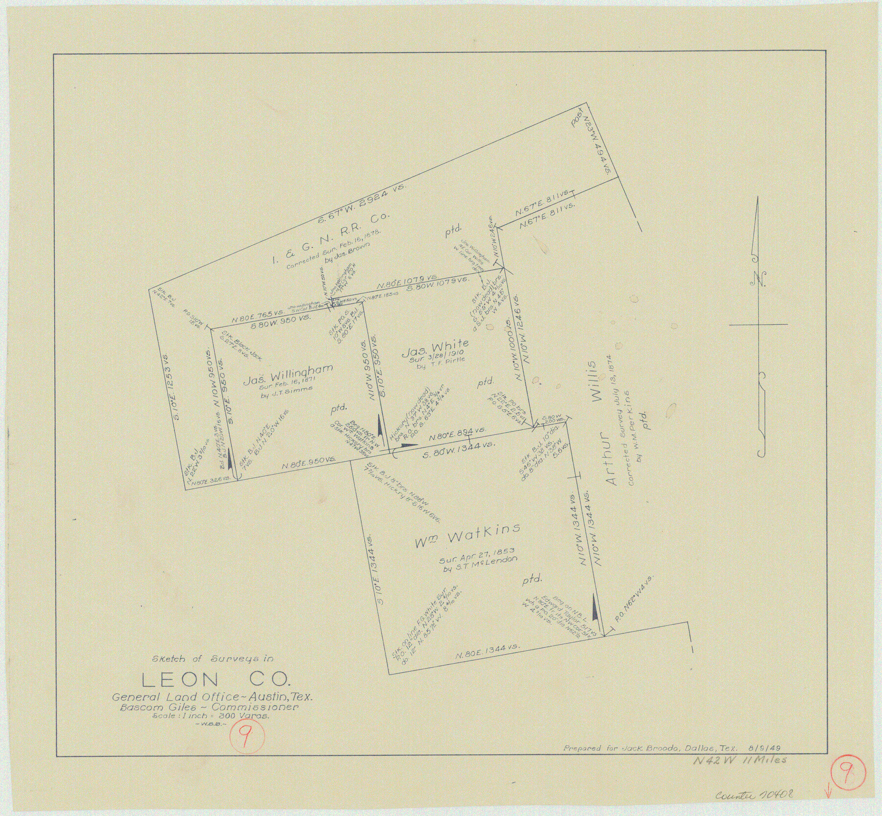
Leon County Working Sketch 9
-
Map/Doc
70408
-
Collection
General Map Collection
-
Object Dates
8/9/1949 (Creation Date)
-
People and Organizations
W. S. Brewington (Draftsman)
-
Counties
Leon
-
Subjects
Surveying Working Sketch
-
Height x Width
16.7 x 18.1 inches
42.4 x 46.0 cm
-
Scale
1" = 300 varas
Part of: General Map Collection
Map of Young County

Print $20.00
- Digital $50.00
Map of Young County
1897
Size 44.1 x 37.9 inches
Map/Doc 63140
Flight Mission No. DQN-2K, Frame 78, Calhoun County

Print $20.00
- Digital $50.00
Flight Mission No. DQN-2K, Frame 78, Calhoun County
1953
Size 18.6 x 22.3 inches
Map/Doc 84270
Crockett County Rolled Sketch LO

Print $20.00
- Digital $50.00
Crockett County Rolled Sketch LO
Size 38.7 x 21.1 inches
Map/Doc 5638
Map of the Republic of Texas Shewing [sic] its division into Counties and Latest Improvements to 1837
![476, Map of the Republic of Texas Shewing [sic] its division into Counties and Latest Improvements to 1837, General Map Collection](https://historictexasmaps.com/wmedia_w700/maps/476-1.tif.jpg)
Print $20.00
- Digital $50.00
Map of the Republic of Texas Shewing [sic] its division into Counties and Latest Improvements to 1837
1837
Size 28.2 x 23.0 inches
Map/Doc 476
Flight Mission No. CRC-1R, Frame 154, Chambers County

Print $20.00
- Digital $50.00
Flight Mission No. CRC-1R, Frame 154, Chambers County
1956
Size 18.9 x 22.5 inches
Map/Doc 84716
Guadalupe County Working Sketch 5

Print $3.00
- Digital $50.00
Guadalupe County Working Sketch 5
1940
Size 15.2 x 10.9 inches
Map/Doc 63314
PSL Field Notes for Blocks G, L, P, and Q in Cochran and Yoakum Counties and Blocks U, V, W, Y, and Z in Cochran County

PSL Field Notes for Blocks G, L, P, and Q in Cochran and Yoakum Counties and Blocks U, V, W, Y, and Z in Cochran County
Map/Doc 81645
Platt [sic] of Late Surveys on Carancahua, Jackson County
![78360, Platt [sic] of Late Surveys on Carancahua, Jackson County, General Map Collection](https://historictexasmaps.com/wmedia_w700/maps/78360.tif.jpg)
Print $2.00
- Digital $50.00
Platt [sic] of Late Surveys on Carancahua, Jackson County
Size 10.9 x 8.0 inches
Map/Doc 78360
Edwards-Kinney County Line, Field Notes & Correspondence, 1933

Print $42.00
- Digital $50.00
Edwards-Kinney County Line, Field Notes & Correspondence, 1933
1931
Size 11.2 x 8.7 inches
Map/Doc 62881
Hutchinson County Rolled Sketch 44-8

Print $20.00
- Digital $50.00
Hutchinson County Rolled Sketch 44-8
2002
Size 24.0 x 36.0 inches
Map/Doc 77544
Map of Coryell Co[unty]
![16951, Map of Coryell Co[unty], General Map Collection](https://historictexasmaps.com/wmedia_w700/maps/16951-1.tif.jpg)
Print $40.00
- Digital $50.00
Map of Coryell Co[unty]
1896
Size 49.8 x 47.7 inches
Map/Doc 16951
Limestone County Sketch File 10

Print $4.00
- Digital $50.00
Limestone County Sketch File 10
Size 8.4 x 9.4 inches
Map/Doc 30171
You may also like
[Right of Way & Track Map, The Texas & Pacific Ry. Co. Main Line]
![64665, [Right of Way & Track Map, The Texas & Pacific Ry. Co. Main Line], General Map Collection](https://historictexasmaps.com/wmedia_w700/maps/64665.tif.jpg)
Print $20.00
- Digital $50.00
[Right of Way & Track Map, The Texas & Pacific Ry. Co. Main Line]
Size 11.0 x 18.4 inches
Map/Doc 64665
Culberson County Rolled Sketch 58

Print $40.00
- Digital $50.00
Culberson County Rolled Sketch 58
1979
Size 37.8 x 52.6 inches
Map/Doc 8759
Flight Mission No. CRK-8P, Frame 119, Refugio County

Print $20.00
- Digital $50.00
Flight Mission No. CRK-8P, Frame 119, Refugio County
1956
Size 18.3 x 22.0 inches
Map/Doc 86974
Flight Mission No. BRA-16M, Frame 125, Jefferson County

Print $20.00
- Digital $50.00
Flight Mission No. BRA-16M, Frame 125, Jefferson County
1953
Size 18.5 x 22.6 inches
Map/Doc 85735
Webb County Sketch File A1

Print $20.00
- Digital $50.00
Webb County Sketch File A1
1897
Size 20.3 x 20.3 inches
Map/Doc 12604
Sulphur River, Boxelder Sheet/Cuthand Creek

Print $20.00
- Digital $50.00
Sulphur River, Boxelder Sheet/Cuthand Creek
1922
Size 29.5 x 25.1 inches
Map/Doc 65156
Leon County Working Sketch 60

Print $20.00
- Digital $50.00
Leon County Working Sketch 60
2005
Size 20.7 x 31.3 inches
Map/Doc 83575
Hill County Sketch File 24

Print $40.00
- Digital $50.00
Hill County Sketch File 24
Size 15.6 x 13.8 inches
Map/Doc 26516
Comanche County Sketch File 17

Print $14.00
- Digital $50.00
Comanche County Sketch File 17
Size 8.5 x 8.2 inches
Map/Doc 19086
Brewster County Working Sketch 28

Print $20.00
- Digital $50.00
Brewster County Working Sketch 28
1940
Size 23.5 x 32.9 inches
Map/Doc 67562

Tom Green County Boundary File 2

Print $50.00
- Digital $50.00
Tom Green County Boundary File 2
Size 14.5 x 9.0 inches
Map/Doc 59335